
Maproom

Dynamic Mapping Suite

  • about
  • news
  • contact
  • 0 items
Log in

How to use the dynamic mapping tools

  • Demos
  • Locations Plotter
    • Learn the basics in 5 minutes
    • Set a radius with auto-calculating population and household figures
    • Drawing lines and shapes
    • Display options
    • Set colour keys and text category filters
    • Bulk edit locations in a table
    • Import and export spreadsheet data
  • Overview of postcode mapping tools – FAQs
  • Quick Select Postcodes
    • Quick start tutorial
    • Edit your popups
    • Import and export postcode data
    • Add your company logo and refine the view settings
    • Add point markers and radii
  • Choropleth / Heat Maps
  • General Reference
    • Access control
    • Going public
    • Make static screen prints and PDFs
    • Duplicate or delete a map

Drawing lines and shapes

1 Draw a line

Click the line icon to enter line drawing mode.

Draw by clicking the map at points along your line. You can work at any zoom level, and pan and zoom in and out as you go.

Don’t worry if you go wrong whilst drawing – you can come back later to move and delete individual points. Just keep clicking until you get to the end of the line. Then either double-click the last point or press Enter to finish drawing.

Immediately a panel will open where you can set the line colour, width and style, and also give it extra content such as a name, description, web link and image. Click Save.

Press Escape or the line icon again if you want to cancel and exit line drawing mode without saving.

Step 1 of 4

2 Reshape a line

To reshape a line, either click its name in the sidebar or the line itself. A popup will appear with buttons for Edit Style & Content, Reshape or Delete.

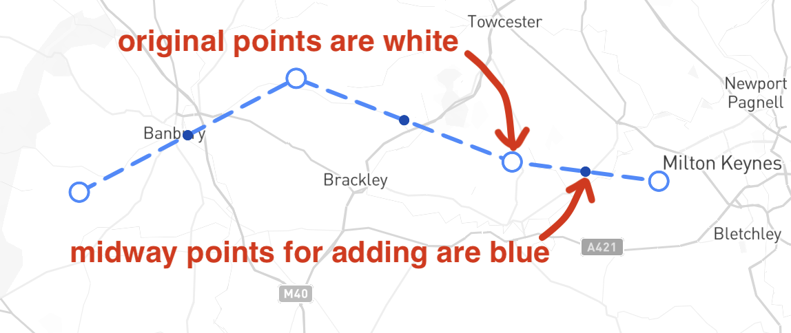
In Reshaping mode, each point that you set earlier will show up as a white circle. In between the white circles are smaller blue circles which are midway points between your white circles.

Click a white point to activate it for reshaping. Drag the point to reshape the line, or press Delete or Backspace to remove the point.

To add a new point, click on a blue midway point to activate it. It will turn white, then you can drag the new point to a new position.

When you’re done with reshaping a line, click Save New Shape to finish and exit Reshaping mode.

Step 2 of 4

3 Draw a polygon area shape

Click the polygon icon to enter area / polygon shape drawing mode.

Draw by clicking the map at points around the area perimeter. You can work at any zoom level, and pan and zoom in and out as you go.

Don’t worry if you go wrong whilst drawing – you can come back later to move and delete individual points. Notice that the first point you clicked shows up as a circle. Just keep clicking until you want to finish. Then either single-click on the first point you set, or double-click the last point, or press Enter. Any of these methods will close the shape and open up the options panel. Or press Escape or the polygon icon again to cancel drawing and exit the area drawing mode.

In the options panel you can set the fill colour and opacity, and the border colour and width. You can also put in extra content such as a name, description, web link and image. Click Save when done.

If you draw an area anywhere in the UK or Republic of Ireland, by default the system will automatically calculate population for the area. This information will show in a popup as you hover over the area. You can turn off population and households calculations in Display Settings if this feature is not useful for you.

Step 3 of 4

4 Reshape a polygon

To reshape an area, either click the area on the map or its name in the sidebar. A popup will appear with buttons for Edit Style & Content, Reshape or Delete.

In Reshaping mode, each point that you set earlier will show up as a white circle. In between the white circles are smaller blue circles which are midway points between your white circles.

Click a white point to activate it for reshaping. Drag the point to reshape the area, or press Delete or Backspace to remove the point.

To add a new point, click on a blue midway point to activate it. It will turn white and you can immediately drag it to a new position.

When you’re done with reshaping an area, either click outside the polygon or the Save New Shape button to finish and exit Reshaping mode.

The population and household figures will automatically update for your reshaped area if enabled.

Step 4 of 4 Tutorial complete!
  • Standard royalty free terms for downloadable maps
  • How to edit the downloadable maps
  • Licensing terms for dynamic online maps
  • Refund, tax and pricing policies
  • How to cancel or change a subscription
  • Privacy & cookies

All content © Maproom at Blue Island Media · Award winning media projects