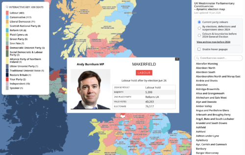
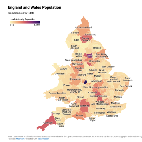
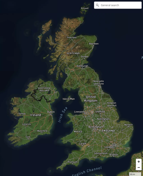
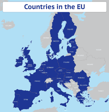
Maproom

Editable & interactive maps

  • about us
  • blog
  • contact
  • 0 items
LOGIN | DYNAMIC MAPPING SUITE
  • Britain & Ireland maps
    • Britain and Ireland
    • UK - United Kingdom
    • Ireland
    • England
    • Scotland
    • Wales
    • Northern Ireland
    • Isle of Man
    • Channel Islands
  • City maps
    • Birmingham
    • Brighton
    • Bristol
    • Cardiff
    • Edinburgh
    • Glasgow
    • Liverpool
    • London
    • Manchester
    • New York
    • Oxford
  • ONS & admin maps
    • Office for National Statistics (ONS) maps
    • Local authority maps
    • County maps
  • Postcode maps
    • Overview
    • Downloadable postcode maps
    • Dynamic online postcode maps
  • World maps
    • World maps
    • Europe maps
    • Map of EU countries after Brexit
    • Maps of France
    • Maps of Germany
    • Maps of New York and environs
  • Dynamic maps
    • Dynamic Maps Showcase
    • Dynamic Mapping Suite
  • Go bespoke
    • Bespoke mapping services
    • Examples of bespoke mapping
    • Demo of a bespoke dynamic map
    • Get quote for a bespoke dynamic map

Try our new Quick Select online editing system to colour and caption postcode maps

19 February 2021

Preview of dynamic online postcode map editor screen

If we hadn't been so busy with the pandemic and Brexit-related work in 2020, we would have launched the new Quick Select editing system months ago! Anyhow, it's finally landed – the ability to colour your postcode maps simply with point and click colouring. The system is available on demand by month-to-month subscription. Go to the live demo of the Quick Select system to try out the tools. ... Read more

Filed Under: Maproom News

New interactive online map published – Listed Buildings of Historic England

3 August 2020

Historic England listed buildings map preview

We've been busy in lockdown and built a wonderful interactive map of listed buildings in England. The first thing we did after flowing in the data was to look up listed buildings in our own neighbourhood. What will you find in your own areas of interest? The map is a demo of how we can create a wonderfully detailed online map using a large dataset. Learn more ... Read more

Filed Under: Maproom News

New map of EU issued after Brexit

1 February 2020

Map of EU countries after Brexit preview 1

Maproom has issued a new map of the EU after the United Kingdom leaves. Customers who purchased the previous EU map will find the new one in the bundle available on their original download link. This time we have issued the map in two colour stylings, one using the EU's dark blue, with the EU flag in the corner of the map; the other more restful tones. Ready to use PDFs and PNGs are in the package. Designers using Adobe Illustrator or other vector artwork software will be able to style the colours and all other elements however they please. Get the new EU map. The EU map is also included in the general Europe maps with country outlines for a modest extra cost. ... Read more

Filed Under: Maproom News

Displaying Shetland in a box on maps is now banned by law on official documents. Seriously.

4 October 2018

Today a new law brought by the Islands (Scotland) Bill has come into force to ban public bodies from using maps that display Shetland in a box rather than in its natural geographic position 150 miles north of the Scottish mainland.  The BBC article about the law, instigated by Islands Lib Dem MSP Tavish Scott and supported by many who live on the Shetland Islands, uses a version of Maproom's Outline Map of Scotland to illustrate the news item. Now, whilst we are delighted to spot one of our maps getting a lot of attention, we want to point out that this map and most of our other Scotland and UK maps have always offered designers the option on whether to show Scotland in its accurate geographical position or in an inset box. Shetland in its natural position puts a lot of sea on the map, with mainland Scotland taking up only half the available space Shetland in a box is a more efficient use of space – but this is now BANNED on official documents With a ... Read more

Filed Under: Maproom News

Our London base map used in BBC drama Bodyguard

28 August 2018

London Street Map in BBC drama Bodyguard

Maproom has signed a number of release forms for TV production companies in recent years, and we were pleased to spot our London Street Map being used to good effect in the new BBC series Bodyguard last night.  Our map appears in a scene in which actor Gina McKee, playing Commander Anne Sampson of the Metropolitan Police's Counter Terrorism Command, has a team tracking a terrorist cell online whilst police race through South London to try to stop the terrorists reaching a school. The production team used one of our base map versions then added some moving coloured dots to signify the police car and terrorists' van moving down Brixton Road. The Bodyguard series is so far displaying itself a tightly woven fiction using many real locations, real BBC newscasters, and plausible events that echo the kind of real terrorist attacks we've experienced in the UK over the past decade. The tension ratcheting up in the first 20 minutes of Episode 1 made for compelling viewing, ... Read more

Filed Under: Maproom News Tagged With: TV map graphics

Maps for travel guide to islands in the River Thames

21 August 2018

Maps for Carl Goes London Islands

Maproom recently had the pleasure of providing map bases for a delightful new travel guide in the creative and distinctive Carl Goes series. The book, called Carl Goes London Islands, tells stories of the islands and islanders of the River Thames. With Maproom's parent company being Thameside Media, the River Thames is close to our studio literally and in our hearts. Not only that, we also have a special interest in travel guides, having published many ourselves over two decades (though never specifically for the Thames). Thus we were delighted to oblige when Sascha Mengerink, the Netherlands-based publisher of the Carl Goes series, asked Maproom if we could provide detailed map bases of the Thames Valley showing all the islands set within the River Thames between the mouth of the river at Canvey Island in Essex upriver through central London to the tiny eyots and aits in the Thames in Surrey and Berkshire. We were able to oblige with map bases using Ordnance Survey open data ... Read more

Filed Under: Bespoke Mapping Samples, Maproom News, Travel Maps

China is now censoring world maps

25 May 2018

China and surrounding countries on the Maproom world map

It has been brought to our attention that Chinese authorities are now subjecting world maps to a process of verification to ensure they conform to China's sovereignty claims. For example, the depiction of disputed territories such as Taiwan and islands in the South China Sea and gas fields in the East China Sea must conform to Beijing's official view. Map projection, affecting the size of China in comparison with the rest of the world, is also under scrutiny. These restrictions affect all products sold in China, including maps on merchandise and within books, and they also affect maps printed in China on products destined for markets outside of China. The latter are now being impounded at Chinese customs whilst the authorities examine their origination and design. Consequences for products deemed to violate Chinese sovereignty may include fines and the order for companies to withdraw and destroy products. Recent cases include Gap being forced to apologise for selling T-shirts in ... Read more

Filed Under: Maproom News

Only In Edinburgh – beautiful and erudite new travel guide using Maproom maps

13 December 2016

Maproom's parent company, Thameside Media, is closely associated with illustrated travel guides, having produced dozens of travel guides for different publishers over the years, including Eyewitness Japan, Blue Guide India, Real City Barcelona and Top 10 Algarve. This is why we were especially delighted and only too pleased to oblige when Duncan J.D. Smith, knowledgeable author of the Only In travel guides, approached Maproom to build custom maps of Edinburgh and her environs for his well-researched new guide, Only In Edinburgh. This guide is organised with thematic spreads delving into the more unexpected and unusual aspects of Scotland's capital. So that, rather than a dry description of St Mary's Metropolitan Cathedral, we leap into the story of Leith-born sculptor Eduardo Paolozzi, whose giant foot sculpture is installed in the cathedral forecourt. We trace J.K. Rowling's coffee hangouts and speculate on the manifestation of the real George Heriot's Castle, Lauriston, Raeburn and ... Read more

Filed Under: Maproom News, Travel Maps

  • Dynamic Mapping Suite – PRICING – FAQs
  • Standard royalty free terms for downloadable maps
  • Licensing terms for downloadable postcode maps
  • Licensing terms for dynamic online maps
  • How to edit the downloadable maps
  • Pricing & refund policies
  • Privacy & cookies

All content © Maproom at Thameside Media · Award winning media projects