Maproom

Editable & interactive maps

  • about us
  • blog
  • contact
  • 0 items
LOGIN | DYNAMIC MAPPING SUITE
  • Britain & Ireland maps
    • Britain and Ireland
    • UK - United Kingdom
    • Ireland
    • England
    • Scotland
    • Wales
    • Northern Ireland
    • Isle of Man
    • Channel Islands
  • City maps
    • Birmingham
    • Brighton
    • Bristol
    • Cardiff
    • Edinburgh
    • Glasgow
    • Liverpool
    • London
    • Manchester
    • New York
    • Oxford
  • ONS & admin maps
    • Office for National Statistics (ONS) maps
    • Local authority maps
    • County maps
  • Postcode maps
    • Overview
    • Downloadable postcode maps
    • Dynamic online postcode maps
  • World maps
    • World maps
    • Europe maps
    • Map of EU countries after Brexit
    • Maps of France
    • Maps of Germany
    • Maps of New York and environs
  • Dynamic maps
    • Dynamic Maps Showcase
    • Dynamic Mapping Suite
  • Go bespoke
    • Bespoke mapping services
    • Examples of bespoke mapping
    • Demo of a bespoke dynamic map
    • Get quote for a bespoke dynamic map

Maps of Brighton

Showing all 2 results

  • Brighton and Hove street map preview small

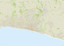
    Brighton and Hove Street Map

    £60.00

    Highly detailed layered vector artwork street map of Brighton and Hove. Includes all local roads and building shapes, with all elements fully editable in Adobe Illustrator.

  • BN postcode districts map preview

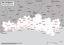
    Map of BN postcode districts – Brighton

    £9.99

    The BN – Brighton postcode districts scaled for A4+ printing

  • Dynamic Mapping Suite – PRICING – FAQs
  • Standard royalty free terms for downloadable maps
  • Licensing terms for downloadable postcode maps
  • Licensing terms for dynamic online maps
  • How to edit the downloadable maps
  • Pricing & refund policies
  • Privacy & cookies

All content © Maproom at Thameside Media · Award winning media projects