Maproom

Editable & interactive maps

MENUMENU
  • about
  • news
  • contact
  • 0 items
LOGIN
    • Home
  • Britain & Ireland maps
    • Britain and Ireland
    • UK - United Kingdom
    • Ireland
    • England
    • Scotland
    • Wales
    • Northern Ireland
    • Isle of Man
    • Channel Islands
  • City maps
    • Birmingham
    • Brighton
    • Bristol
    • Cardiff
    • Edinburgh
    • Glasgow
    • Liverpool
    • London
    • Manchester
    • Oxford
  • Postcode maps
    • Overview
    • Online postcode mapping tools
    • Downloadable postcode maps
  • Boundary & transport maps
    • Boundary and ONS maps
    • Local authority maps
    • County maps
    • Transport maps
  • World maps
    • World maps
    • Europe maps
    • Map of EU countries 2023
    • Maps of France
    • Maps of Germany
    • Maps of New York and environs
  • DYNAMIC
    • Showcase
    • Dynamic Mapping Suite information and demos
    • GET A PASS
  • BESPOKE
    • Bespoke mapping services
    • Bespoke static maps
    • Bespoke dynamic maps
    • Search

Maproom News & Blog

  • Mapping from spreadsheets system launched in our Dynamic Mapping Suite
  • New census mapping
  • Our 3d map of British and Irish mountains is an immersive demo of new techniques with advanced satellite imagery and filters
  • Europe and world maps updated for geopolitical events in 2022
  • Mapping the Elizabeth Line
  • Mapbox and Google Maps fees for high web traffic
  • The Dulwich Estate goes live with a public swipe-comparison map we built for them
  • Try our new Quick Select online editing system to colour and caption postcode maps
  • New interactive online map published – Listed Buildings of Historic England
  • New map of EU issued after Brexit
  • Displaying Shetland in a box on maps is now banned by law on official documents. Seriously.
  • Our London base map used in BBC drama Bodyguard
  • Maps for travel guide to islands in the River Thames
  • China is now censoring world maps
  • Only In Edinburgh – beautiful and erudite new travel guide using Maproom maps
  • Animated map of EU Countries, Schengen Area, Eurozone, Single Market and Hard Brexit
  • The surprising story of Thomas Hardy in Surbiton
  • 2,500 map plottings for Betjeman’s Best British Churches
  • Our World Whisky book wins prestigious award

Try our new Quick Select online editing system to colour and caption postcode maps

19 February 2021

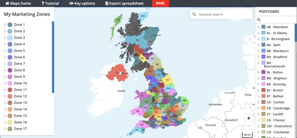
If we hadn’t been so busy with the pandemic and Brexit-related work in 2020, we would have launched the new Quick Select editing system months ago! Anyhow, it’s finally landed – the ability to colour your postcode maps simply with point and click colouring. The system is available with a premium pass for our Dynamic Mapping Suite.

Go to the live demo of the Quick Select system to try out the tools.

Quick Select dynamic interactive postcode map colouring and labelling system

Filed Under: Maproom News

  • Standard royalty free terms for downloadable maps
  • Licensing terms for downloadable postcode maps
  • Licensing terms for dynamic online maps
  • How to edit the downloadable maps
  • Pricing & refund policies
  • Privacy & cookies
  • Maproom on Twitter

All content © Maproom at Thameside Media · Award winning media projects