Maproom

Interactive & editable digital maps

  • about
  • news
  • contact
  • 0 items
Log in
  • Britain & Ireland maps
    • Britain and Ireland
    • UK - United Kingdom
    • Ireland
    • England
    • Scotland
    • Wales
    • Northern Ireland
    • Isle of Man
    • Channel Islands
  • City maps
    • Birmingham
    • Brighton
    • Bristol
    • Cardiff
    • Edinburgh
    • Exeter
    • Glasgow
    • Liverpool
    • London
    • Manchester
    • Oxford
  • Postcode maps
    • Overview
    • Dynamic postcode mapping tools
    • Downloadable postcode maps
  • Admin / region maps
    • UK administrative regions
    • County maps
    • Local authority maps
    • London borough maps
    • Transport maps
    • National park maps
  • World maps
    • World maps
    • Europe maps
    • Map of EU countries 2026
    • Maps of France
    • Maps of Germany
    • Maps of New York and environs
  • DYNAMIC MAPPING
    • Showcase
    • Dynamic Mapping Suite info
    • PASS PRICING
  • BESPOKE

Mapping the Past

Dulwich Estate swipe map preview

The Dulwich Estate goes live with a public swipe-comparison map we built for them

27 May 2022

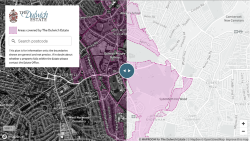
Much of our interactive mapping work commissioned by clients is private – intended for an organisation’s internal use and therefore not available to show off as our work. However, one of the interactive maps we have built for The Dulwich Estate in south London is now displayed publicly on their website. A deep-zoom swipe map, …READ MORE…

Map of Thomas Hardy location in Surbiton

The surprising story of Thomas Hardy in Surbiton – mapping the past

30 October 2016

Hook Road in Surbiton is dotted with a few handsome villas that survive from the 1870s. One of these, a Victorian townhouse at number 15, bears a blue plaque for the famous novelist and poet Thomas Hardy. It comes as a surprise to many to learn that Thomas Hardy was living in this vicinity in …READ MORE…

Scotland maps in Betjeman's Best British Churches

2,500 map plottings for Betjeman’s Best British Churches

11 January 2012

One of our greatest projects for Harper Collins publishers recently involved the mapping and photography of churches around Britain. Altogether we plotted the location of 2,500 churches using digital GPS data and translating it onto printed maps. It represents a massive achievement and huge improvement on the original black and white map bullets in the …READ MORE…

  • Standard royalty free terms for downloadable maps
  • Licensing terms for downloadable postcode maps
  • Licensing terms for dynamic online maps
  • How to edit the downloadable maps
  • Refund, tax and pricing policies
  • Privacy & cookies

All content © Maproom at Blue Island Media · Award winning media projects