Maproom

Editable & interactive digital maps

  • about
  • news & blog
  • contact
  • 0 items
Log in
    • Home
  • Britain & Ireland maps
    • Britain and Ireland
    • UK - United Kingdom
    • Ireland
    • England
    • Scotland
    • Wales
    • Northern Ireland
    • Isle of Man
    • Channel Islands
  • City maps
    • Birmingham
    • Brighton
    • Bristol
    • Cardiff
    • Edinburgh
    • Exeter
    • Glasgow
    • Liverpool
    • London
    • Manchester
    • Oxford
  • Postcode maps
    • Overview
    • Dynamic postcode mapping tools
    • Downloadable postcode maps
  • Admin / region maps
    • UK administrative regions
    • County maps
    • Local authority maps
    • London borough maps
    • Transport maps
    • National park maps
  • World maps
    • World maps
    • Europe maps
    • Map of EU countries 2026
    • Maps of France
    • Maps of Germany
    • Maps of New York and environs
  • DYNAMIC MAPPING
    • Showcase
    • Dynamic Mapping Suite info
    • PASS PRICING
  • BESPOKE

DYNAMIC MAPPING SUITE PORTAL

  • Dynamic Mapping Suite
  • Pass Pricing
  • Login

Tools in the Dynamic Mapping Suite

  • Locations Plotter examples
  • Radius plotting
  • Quick Select Postcodes
  • Bulk postcodes plotting
  • Mapping with spreadsheets
  • Dynamic postcodes with census data
  • Dynamic UK administrative maps
  • Clean Air Zones + route planning
  • Dynamic maps for MRP polling data

Clean Air Zones / ULEZ / Low Emission / Congestion Charge + postcodes + live traffic interactive map

Clean Air Zones - Low Emission Zones and all UK postcode boundaries interactive map
Clean Air / Low Emission Zones / ULEZ all-in-one interactive map preview

Online mapping aids for businesses, marketing and planning departments

All-in-one reference for postcodes in the London ULEZ plus Clean Air / Low Emission zones in 13 other cities

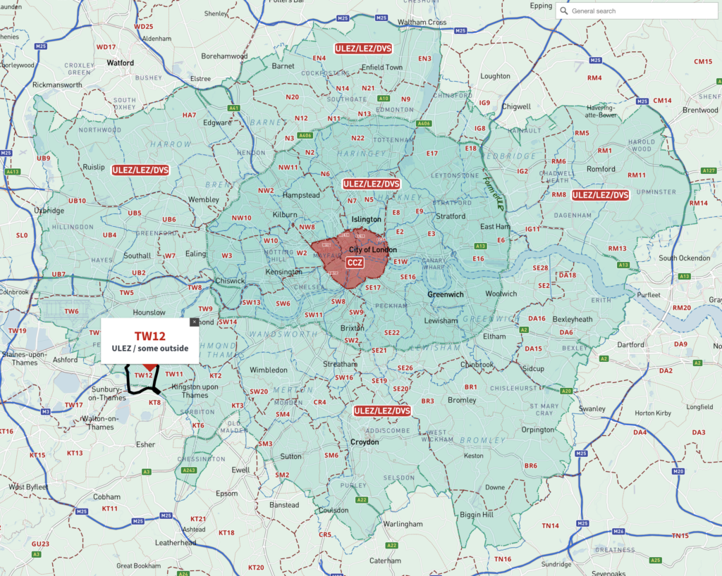
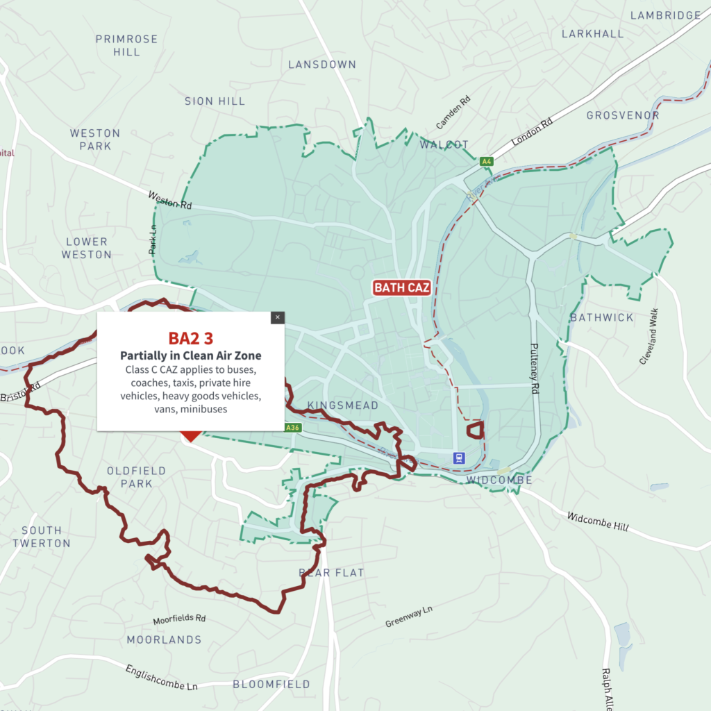
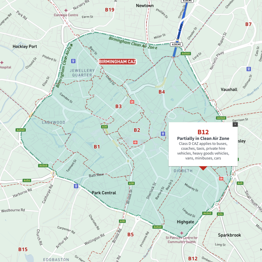
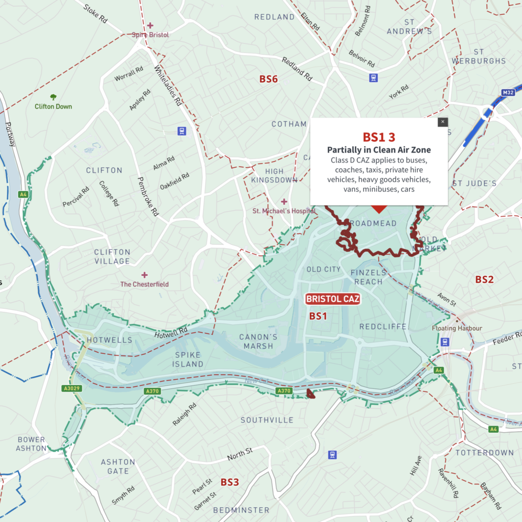
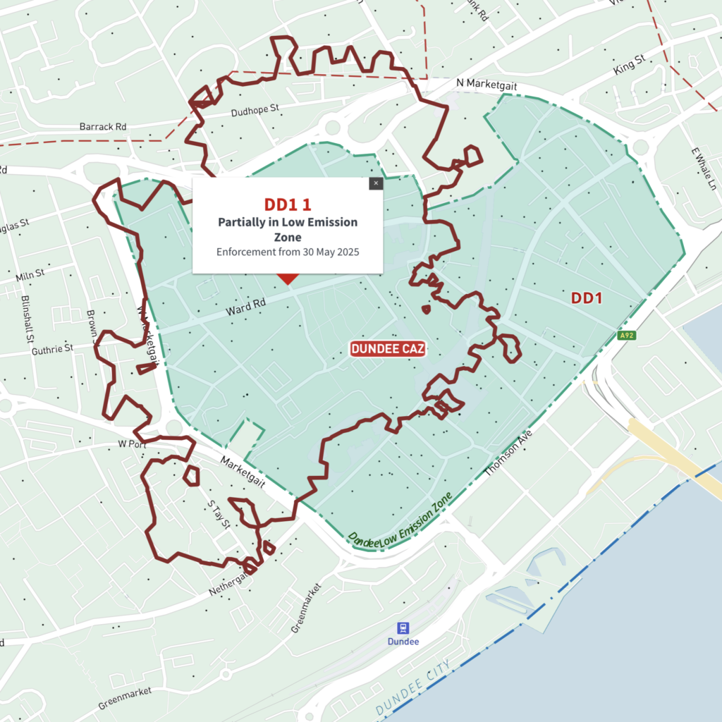
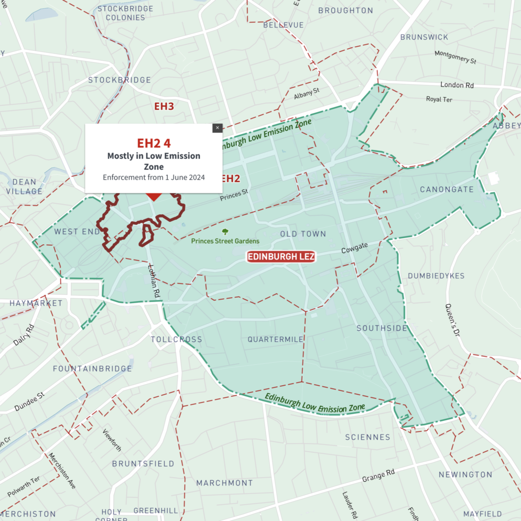
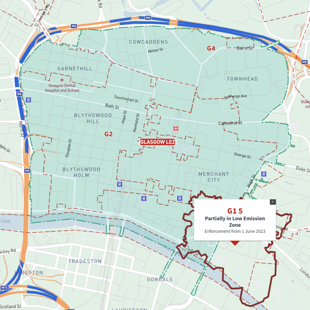
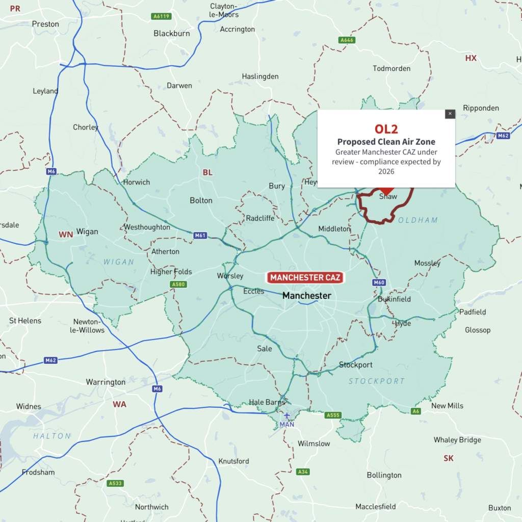
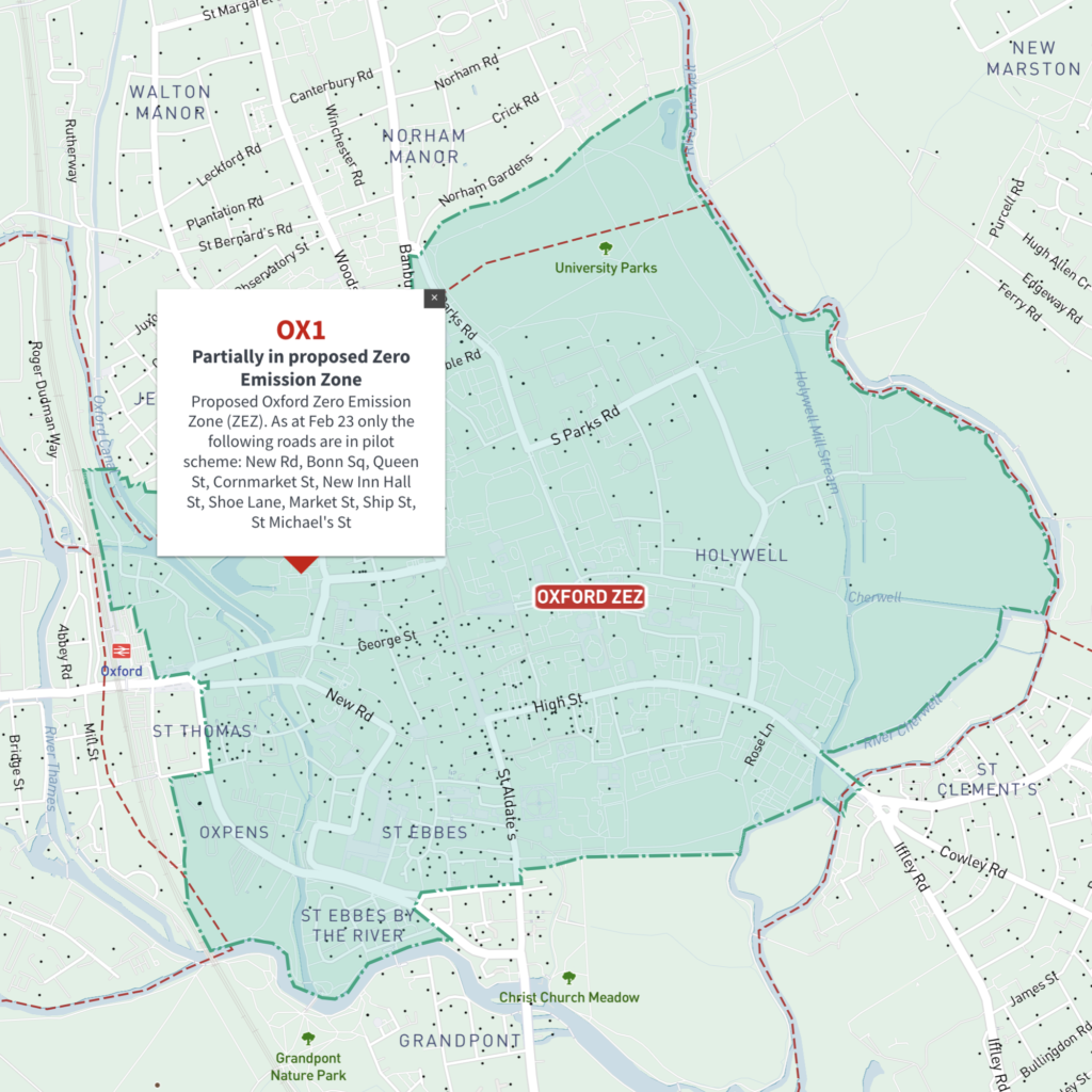
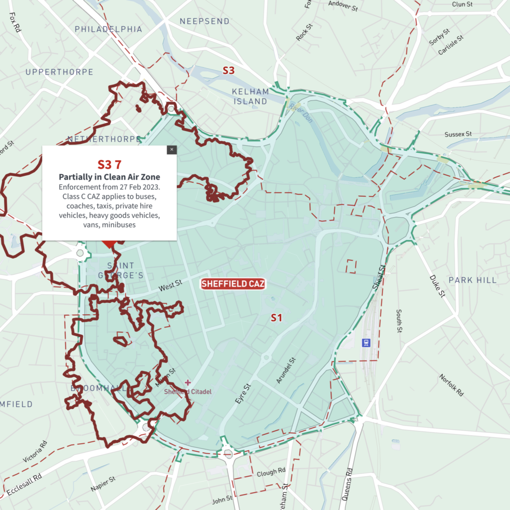
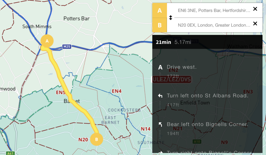
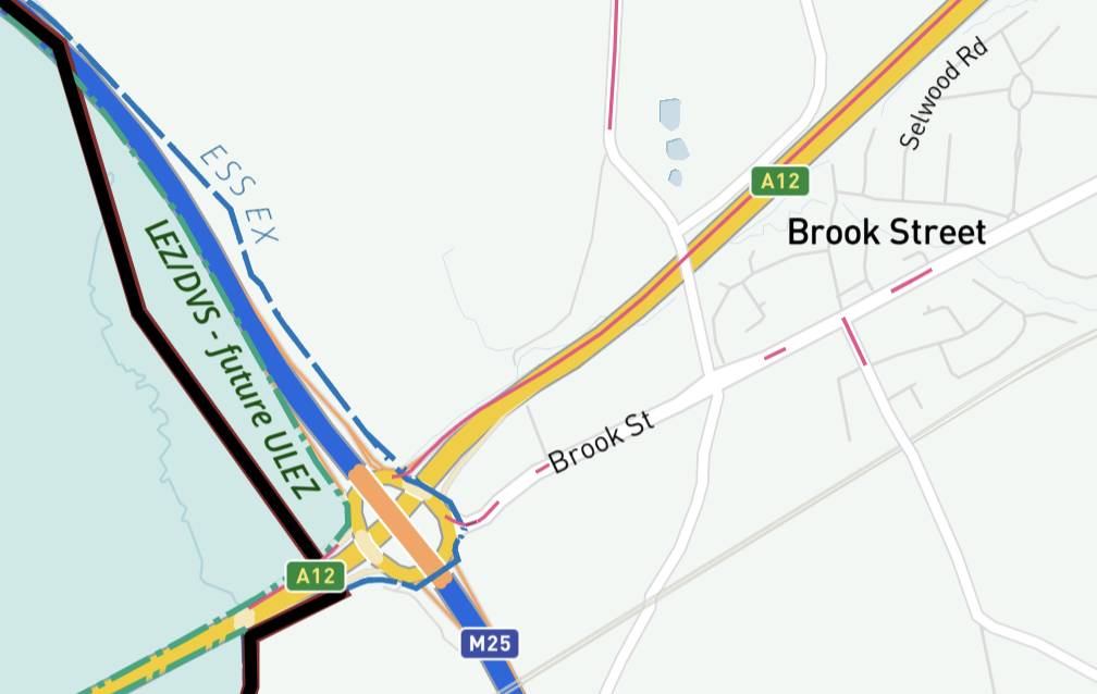
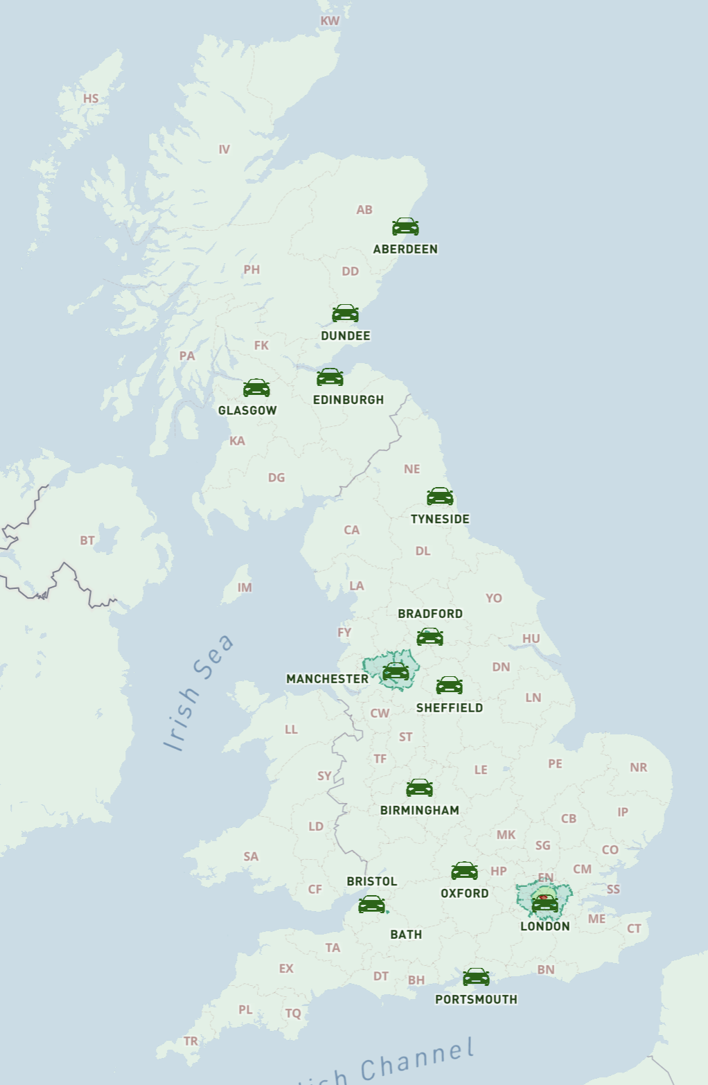
Do you need to work out service charge areas and delivery routes based on postcodes in the Clean Air and Low Emission urban zones? Or are you an urban planner who needs to identify the green city zones at street level? If so, we have a superb interactive reference map for you showing all the LEZ, ULEZ, ZEZ, CCZ and Clean Air Zones juxtaposed with postcode boundaries, borough and county boundaries, and live traffic congestion data. This helpful map provides street level postcode boundary details that are missing from the maps provided by local authorities, gov.uk and Transport for London.

Access to this unique all-in-one transport map is available with a pass for our Dynamic Mapping Suite. The pass also includes all other dynamic online reference maps and mapping tools, so you can plot your own postcodes of interest in and around the Clean Air and Low Emission zones.

The greening of UK cities is happening fast, with London’s Ultra-low Emission Zone (ULEZ) expansion in plae, and other Clean Air / Low Emission Zones implemented or coming soon in Birmingham, Sheffield, Glasgow, Edinburgh, Greater Manchester and others (see list below). Oxford is even trialling a Zero Emission Zone (ZEZ). The upshot is a confusing mishmash of rules impacting business pricing and routes for deliveries and service areas within the cities. You need accurate and clear visual reference to identify postcodes in these urban zones.

Use our dynamic online reference maps plus postcode mapping tools to work out your own company’s delivery and service pricing.

See how postcode districts and sectors straddle the zones and quick-check if your customer is inside or outside

The maps in the Dynamic Mapping Suite are fully interactive, with a search box and interactive nested listings that help you locate and identify postcodes at different levels – areas, districts, sectors and individual unit centroids.

This video preview shows how to find postcodes in Birmingham’s Clean Air Zone

Previews of zones in the interactive map

Postcodes in Greater London ULEZ  expansion / DVS, Congestion Charge - interactive map preview
Greater London ULEZ expansion/ DVS, Congestion Charge + postcode boundaries
Aberdeen Low Emission Zone LEZ map + AB postcode boundaries interactive map preview
Aberdeen Low Emission Zone (LEZ) + all AB postcode boundaries
Bath Clean Air Zone map with BA postcode boundaries - interactive map preview
Bath Clean Air Zone (CAZ) + all BA postcode boundaries
Birmingham Clean Air Zone map and B postcode boundaries interactive map preview
Birmingham Clean Air Zone (CAZ) + all B postcode boundaries
Bradford Clean Air Zone map with BD postcode boundaries - interactive map preview
Bradford Clean Air Zone (CAZ) + all BD postcode boundaries
Bristol Clean Air Zone map and BS postcode boundaries interactive map preview
Bristol Clean Air Zone (CAZ) + all BS postcode boundaries
Dundee Clean Air Zone map with DD postcode boundaries - interactive map preview
Dundee Clean Air Zone (CAZ) + all DD postcode boundaries
Edinburgh Low Emission Zone map with interactive EH postcode boundaries preview
Edinburgh Low Emission Zone (LEZ) + all EH postcode boundaries
Glasgow Low Emission Zone map LEZ with G postcodes - interactive map preview
Glasgow Low Emission Zone (LEZ) + all G postcodes
Greater Manchester Clean Air Zone map with M, OL, BL, WN, WA, SK postcode boundaries - interactive map preview
Greater Manchester proposed Clean Air Zone (CAZ) with all M, OL, BL, WN, WA, SK postcode boundaries
Newcastle / Tyneside Clean Air Zone map with NE postcode boundaries - interactive map preview
Newcastle / Gateshead / Tyneside Clean Air Zone (CAZ) with all NE postcode boundaries
Oxford proposed Zero Emission Zone ZEZ map and OX postcode boundaries interactive map preview
Oxford proposed Zero Emission Zone (ZEZ) + all OX postcode boundaries
Portsmouth Clean Air Zone map with PO postcode boundaries - interactive map preview
Portsmouth Clean Air Zone (CAZ) + all PO postcode boundaries
Sheffield Clean Air Zone map with S postcode boundaries - interactive map preview
Sheffield Clean Air Zone (CAZ) + all S postcode boundaries
A to B driving route plotter
If you enter two locations in boxes A and B, a driving route will be automatically highlighted on the map
Congestion pink lines
Option to turn on recent congestion data showing as pink lines on the roads

Try the Dynamic Mapping Suite

GET TEST PASS

No payment card required. Access all mapping tools in Test Mode.

Or buy a full pass from only £25

  • Standard royalty free terms for downloadable maps
  • Licensing terms for downloadable postcode maps
  • Licensing terms for dynamic online maps
  • How to edit the downloadable maps
  • Refund, tax and pricing policies
  • Privacy & cookies

All content © Maproom at Blue Island Media · Award winning media projects