Maproom

Editable & interactive digital maps

MENUMENU
  • about
  • news & blog
  • contact
  • 0 items
LOGIN
    • Home
  • Britain & Ireland maps
    • Britain and Ireland
    • UK - United Kingdom
    • Ireland
    • England
    • Scotland
    • Wales
    • Northern Ireland
    • Isle of Man
    • Channel Islands
  • City maps
    • Birmingham
    • Brighton
    • Bristol
    • Cardiff
    • Edinburgh
    • Exeter
    • Glasgow
    • Liverpool
    • London
    • Manchester
    • Oxford
  • Postcode maps
    • Overview
    • Online postcode mapping tools
    • Downloadable postcode maps
  • Region maps
    • Region maps
    • County maps
    • Local authority maps
    • Transport maps
    • National park maps
  • World maps
    • World maps
    • Europe maps
    • Map of EU countries 2024
    • Maps of France
    • Maps of Germany
    • Maps of New York and environs
  • DYNAMIC
    • Showcase
    • Dynamic Mapping Suite information and demos
    • GET A PASS
  • BESPOKE
    • Bespoke mapping services
    • Bespoke static maps
    • Bespoke dynamic maps
    • Search

DYNAMIC MAPPING SUITE INFORMATION

  • Introduction
  • Dynamic UK Business Reference Maps
  • Point-and-Click Mapping Tools
  • Mapping from Spreadsheets
  • GET A PASS
  • LOGIN

Samples & Demos

  • Spreadsheets to Polygons
  • Locations Plotter
  • Quick Select Postcodes
  • Bulk Postcodes Plotter
  • Radius Plotter
  • Postcode Units at Street Level with Census Data
  • Clean Air Zones / ULEZ / Low Emission + Postcodes + Live Traffic Planning Aids
  • Dynamic Maps for MRP Polling Data
  • Embedding a dynamic map on your own website

Dynamic Maps for MRP Polling Data

We can help you map MRP polling data for the UK’s parliamentary constituencies, local authorities, wards, output areas etc. Contact us if you want to visualise your MRP polling data either in private or showcased publicly.

Examples

Current parties and MPs on current boundaries data

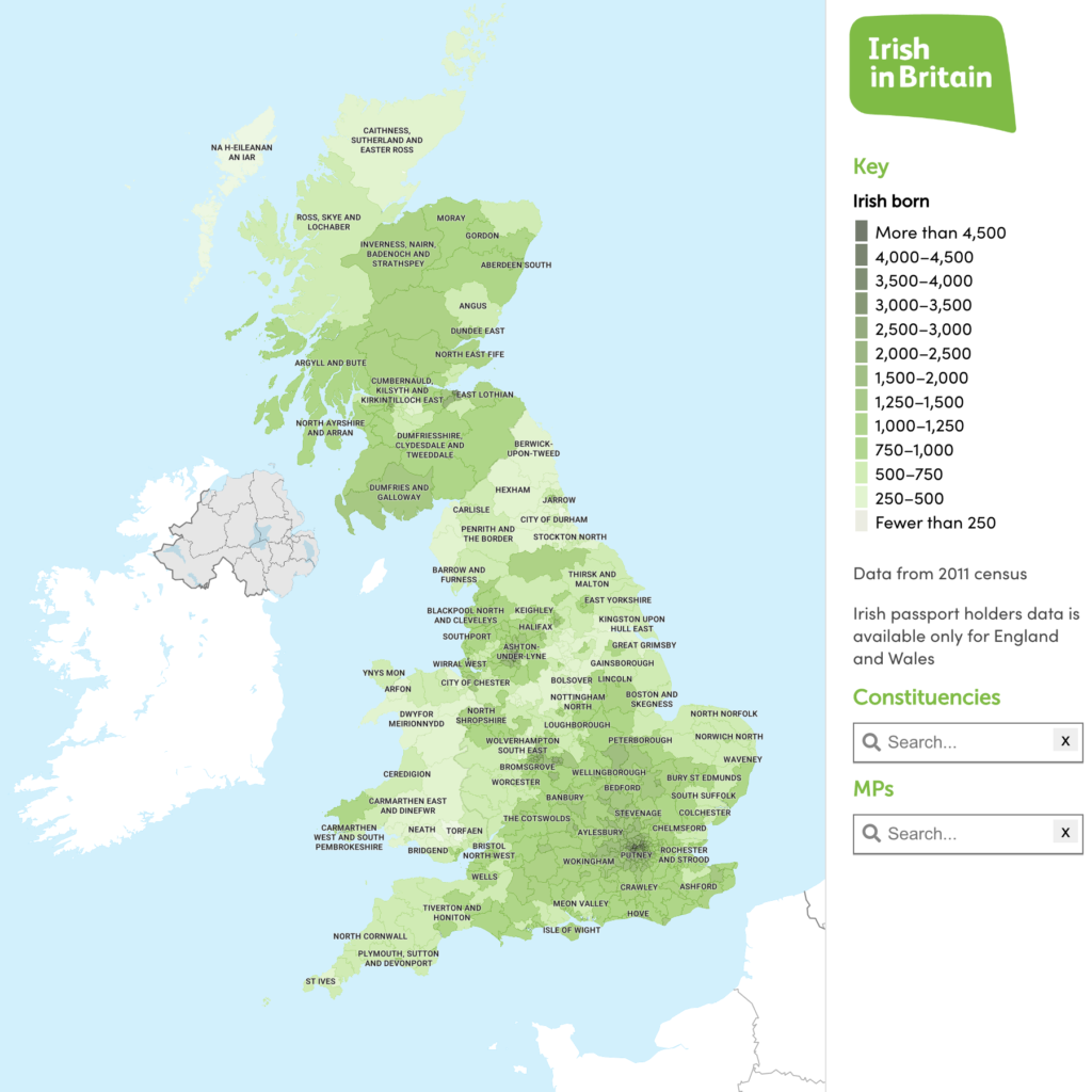
Irish in Britain heat map with constituency data

MRP polling data by FocalData – map for animal welfare consortium

  • Standard royalty free terms for downloadable maps
  • Licensing terms for downloadable postcode maps
  • Licensing terms for dynamic online maps
  • How to edit the downloadable maps
  • Pricing & refund policies
  • Privacy & cookies

All content © Maproom at Blue Island Media · Award winning media projects