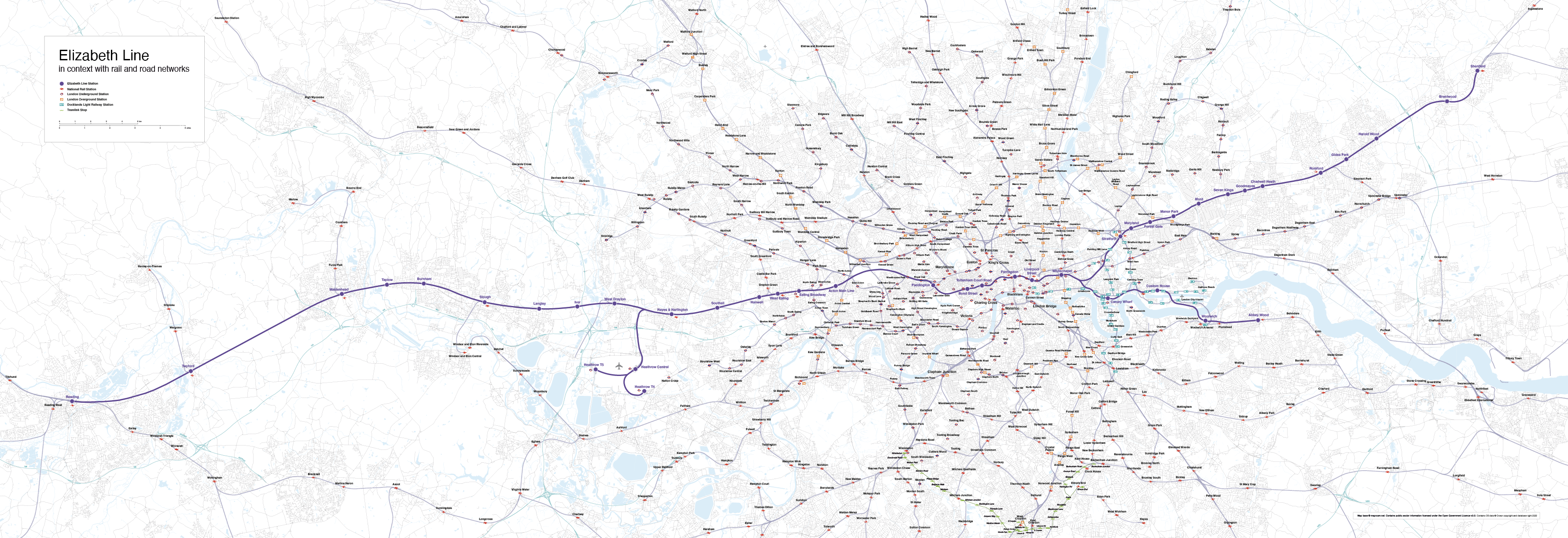
Maproom

Editable & interactive digital maps

MENUMENU
  • about
  • news & blog
  • contact
  • 0 items
LOGIN
    • Home
  • Britain & Ireland maps
    • Britain and Ireland
    • UK - United Kingdom
    • Ireland
    • England
    • Scotland
    • Wales
    • Northern Ireland
    • Isle of Man
    • Channel Islands
  • City maps
    • Birmingham
    • Brighton
    • Bristol
    • Cardiff
    • Edinburgh
    • Exeter
    • Glasgow
    • Liverpool
    • London
    • Manchester
    • Oxford
  • Postcode maps
    • Overview
    • Online postcode mapping tools
    • Downloadable postcode maps
  • Region maps
    • Region maps
    • County maps
    • Local authority maps
    • Transport maps
    • National park maps
  • World maps
    • World maps
    • Europe maps
    • Map of EU countries 2024
    • Maps of France
    • Maps of Germany
    • Maps of New York and environs
  • DYNAMIC
    • Showcase
    • Dynamic Mapping Suite information and demos
    • GET A PASS
  • BESPOKE
    • Bespoke mapping services
    • Bespoke static maps
    • Bespoke dynamic maps
    • Search

Displaying Shetland in a box on maps is now banned by law on official documents. Seriously.

4 October 2018
Filed Under: Maproom News

Today a new law brought by the Islands (Scotland) Bill has come into force to ban public bodies from using maps that display Shetland in a box rather than in its natural geographic position 150 miles north of the Scottish mainland. The BBC article about the law, instigated by Islands Lib Dem MSP Tavish Scott and supported by many who live on the Shetland Islands, uses a version of Maproom's Outline Map of Scotland to illustrate the news item. Now, whilst we are delighted to spot one of our maps getting a lot of attention, we want to point out that this map and most of our other Scotland and UK maps have always offered designers the option on whether to show Scotland in its accurate geographical position or in an inset box.With a Maproom map you will usually find Shetland in its natural geographic position on the first artboard of the Illustrator file. Use this version if you want or need to. Then again, that's a lot of empty sea top left that designers may find ... Read more

Our London base map used in BBC drama Bodyguard

28 August 2018
Filed Under: Maproom News

London Street Map in BBC drama Bodyguard

Maproom maps are popular with TV production companies, and we were pleased to spot our London Street Map being used to good effect in the new BBC series Bodyguard last night. Our map appears in a scene in which actor Gina McKee, playing Commander Anne Sampson of the Metropolitan Police's Counter Terrorism Command, has a team tracking a terrorist cell online whilst police race through South London to try to stop the terrorists reaching a school.The production team used one of our base map versions then added some moving coloured dots to signify the police car and terrorists' van moving down Brixton Road.The Bodyguard series is so far displaying itself a tightly woven fiction using many real locations, real BBC newscasters, and plausible events that echo the kind of real terrorist attacks we've experienced in the UK over the past decade. The tension ratcheting up in the first 20 minutes of Episode 1 made for compelling viewing, and we look forward to the rest of the series. We are hoping ... Read more

Maps for travel guide to islands in the River Thames

21 August 2018
Filed Under: Bespoke Mapping Samples, Maproom News, Travel Maps

Maps for Carl Goes London Islands

Maproom recently had the pleasure of providing map bases for a delightful new travel guide in the creative and distinctive Carl Goes series. The book, called Carl Goes London Islands, tells stories of the islands and islanders of the River Thames.With Maproom's parent company being Thameside Media, the River Thames is close to our studio literally and in our hearts. Not only that, we also have a special interest in travel guides, having published many ourselves over two decades (though never specifically for the Thames). Thus we were delighted to oblige when Sascha Mengerink, the Netherlands-based publisher of the Carl Goes series, asked Maproom if we could provide detailed map bases of the Thames Valley showing all the islands set within the River Thames between the mouth of the river at Canvey Island in Essex upriver through central London to the tiny eyots and aits in the Thames in Surrey and Berkshire. We were able to oblige with map bases using Ordnance Survey open data ... Read more

China is now censoring world maps

25 May 2018
Filed Under: Maproom News

China and surrounding countries on the Maproom world map

It has been brought to our attention that Chinese authorities are now subjecting world maps to a process of verification to ensure they conform to China's sovereignty claims. For example, the depiction of disputed territories such as Taiwan and islands in the South China Sea and gas fields in the East China Sea must conform to Beijing's official view. Map projection, affecting the size of China in comparison with the rest of the world, is also under scrutiny.These restrictions affect all products sold in China, including maps on merchandise and within books, and they also affect maps printed in China on products destined for markets outside of China. The latter are now being impounded at Chinese customs whilst the authorities examine their origination and design.Consequences for products deemed to violate Chinese sovereignty may include fines and the order for companies to withdraw and destroy products.Recent cases include Gap being forced to apologise for selling T-shirts in ... Read more

Only In Edinburgh – beautiful and erudite new travel guide using Maproom maps

13 December 2016
Filed Under: Maproom News, Travel Maps

Maproom's parent company, Thameside Media, is closely associated with illustrated travel guides, having produced dozens of travel guides for different publishers over the years, including Eyewitness Japan, Blue Guide India, Real City Barcelona and Top 10 Algarve.This is why we were especially delighted and only too pleased to oblige when Duncan J.D. Smith, knowledgeable author of the Only In travel guides, approached Maproom to build custom maps of Edinburgh and her environs for his well-researched new guide, Only In Edinburgh.This guide is organised with thematic spreads delving into the more unexpected and unusual aspects of Scotland's capital. So that, rather than a dry description of St Mary's Metropolitan Cathedral, we leap into the story of Leith-born sculptor Eduardo Paolozzi, whose giant foot sculpture is installed in the cathedral forecourt. We trace J.K. Rowling's coffee hangouts and speculate on the manifestation of the real George Heriot's Castle, ... Read more

Animated map of EU Countries, Schengen Area, Eurozone, Single Market and Hard Brexit

6 December 2016
Filed Under: Animated Maps

EU countries, Schengen, Eurozone, Single Market animated map

  As a demo of what you can do with our base map of EU countries, we've created an animated map gif showing the current EU countries (2016-2019) layered with countries in the Eurozone, countries in the Schengen area, countries in the European Single Market and, finally, the European Single Market as it will look if the UK enacts a Hard Brexit. ... Read more

« Previous Page
Next Page »
  • Standard royalty free terms for downloadable maps
  • Licensing terms for downloadable postcode maps
  • Licensing terms for dynamic online maps
  • How to edit the downloadable maps
  • Pricing & refund policies
  • Privacy & cookies

All content © Maproom at Blue Island Media · Award winning media projects