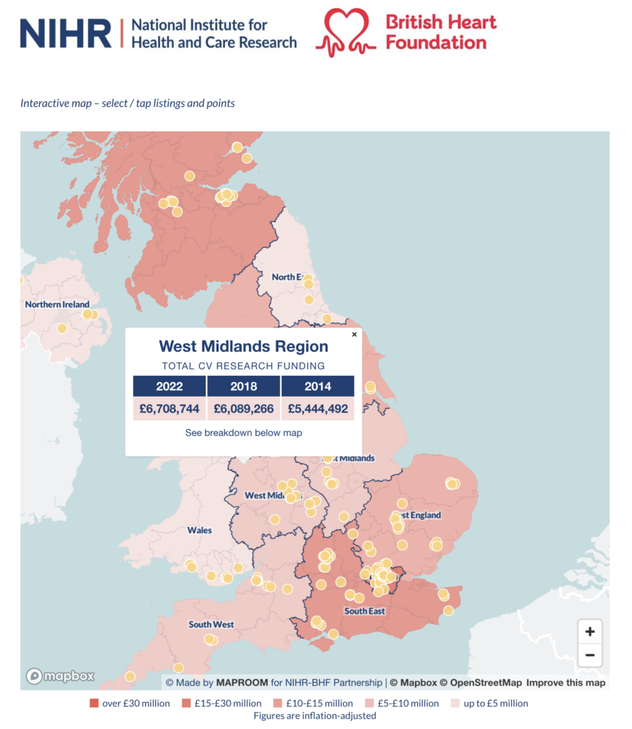
We are delighted to publish two bespoke interactive maps for the NIHR-British Heart Foundation Partnership, which show the funding regions and member centres for millions of pounds worth of cardiovascular research in the UK. The maps took several months to compile data for and programmed as native embeds on the Oxford Biomedical Research Centre website.
A to B driving route plotter added to our dynamic online Clean Air Zones map
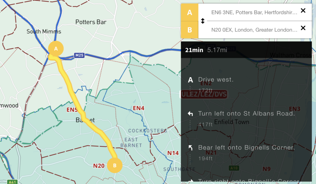
We’ve added an auto-calculating A to B driving route plotter with directions for businesses that need to calculate service charge areas and delivery routes in and around the UK’s Low Emission Zones. See at a glance if your customer’s postcode is in a Low Emission Zone and / or if your route takes you into Greater London’s ULEZ or 13 other Low Emission Zones around UK cities.
For more information and access to this map see Clean Air Zones / ULEZ / Low Emission / Congestion Charge + postcodes + live traffic interactive map
New Local Authorities maps from April 2023 – Cumberland, Westmorland and Furness, North Yorkshire and Somerset
We have updated all our Local Authority map bases in line with changes that have come into effect on 1 April 2023. As far as we can see, we have actually beaten the Government itself in issuing the new boundary data!
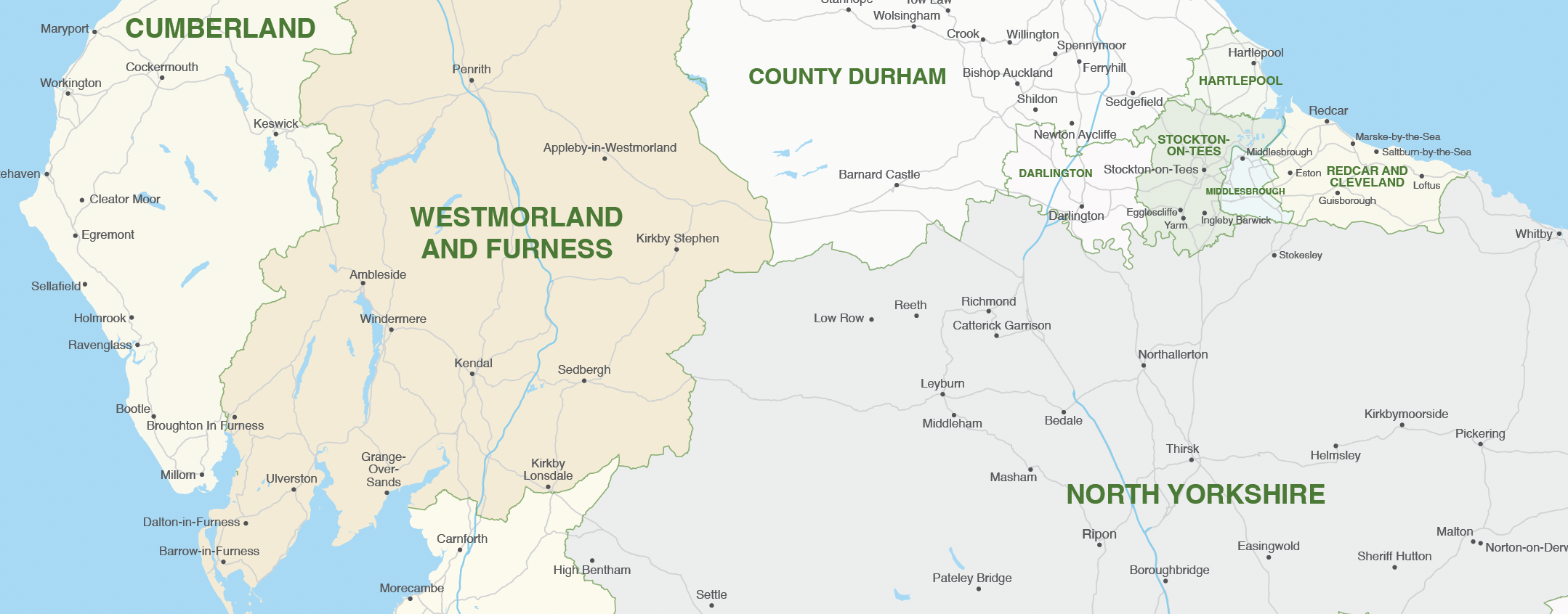
The changes are as follows:
Cumberland – formerly Allerdale, Carlisle, Copeland
Westmorland and Furness – formerly Barrow-in-Furness, Eden, South Lakeland
North Yorkshire – formerly Craven, Hambleton, Harrogate, Richmondshire, Ryedale, Scarborough, Selby
Somerset – formerly Mendip, Sedgemoor, Somerset West and Taunton, South Somerset
We sell two vector art packages for the Local Authorities: one juxtaposed with postcodes and the other without. Both are bundled with a premium pass for the Dynamic Mapping Suite, which contains interactive online maps of the new Local Authorities with advanced search. Users can colour and caption the Local Authorities online with their own data.
If you have data you want to feed to the old Local Authorities, before the April 2023 mergers in Cumbria, Yorkshire and Somerset, we have included an older version in both the download package and in the spreadsheets to polygons system in the Dynamic Mapping Suite. This is handy if, for example, your data relates to the 2021 census.
For more details see UK local authorities maps.
Mapping from spreadsheets system launched in our Dynamic Mapping Suite
A powerful yet easy to use system of connecting spreadsheets to colour and label polygon maps is now available in our Dynamic Mapping Suite, and it costs only a very modest £35 to use.
Currently available for dynamically colouring and captioning from spreadsheet:
- Postcode Districts
- Postcode Sectors
- Ceremonial Counties
- Counties and Unitary Authorities
- Local Authorities
See a live example of a postcode district polygons map connected to a spreadsheet and learn more about mapping from spreadsheets.
New census mapping
The Office for National Statistics has started to release data from the Census 2021. Below are some interactive England and Wales population maps that users can freely use on their own websites. Or commission us to create maps like these using other census data or marrying up census figures with your own data.
Hover or tap different parts of the maps for data interaction
Population change between 2011 and 2021, local authorities in England and Wales
Age structure of the population, 2021, local authorities in England and Wales
Population density, 2021 and changes since 2011, local authorities in England and Wales
Changes in the number of households between 2011 and 2021, local authorities in England and Wales
Our 3d map of British and Irish mountains is an immersive demo of new techniques with advanced satellite imagery and filters
Mapbox – our favourite dynamic mapping base system – released a new system based on Maxar satellite imagery last year, whereby geospatial developers such as us can tap into elevation and projection for satellite views layered with our own points, lines and polygons. We have experimented with the new 3d system in conjunction with our own techniques developed for listing and filtering, and come up with a rather sublime demo using data from The Database of British and Irish Hills.
Open full-size dynamic mountains map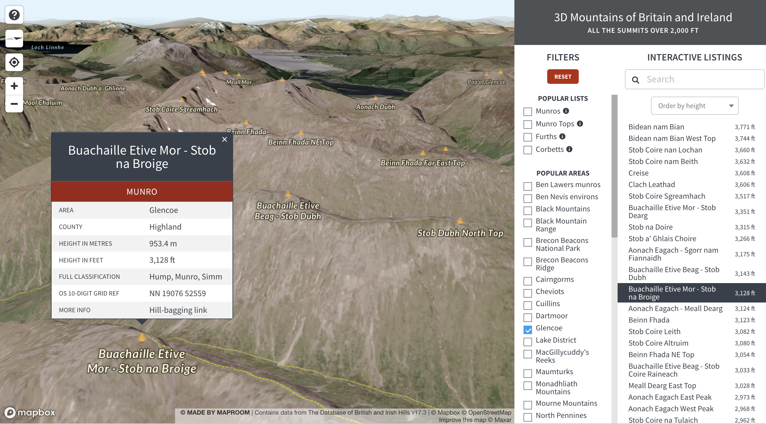
Learn more about how we feed data to dynamic maps like this on the 3d mountains exploration demo page.