Maproom

Interactive & editable digital maps

  • about
  • news
  • contact
  • 0 items
Log in
  • Britain & Ireland maps
    • Britain and Ireland
    • UK - United Kingdom
    • Ireland
    • England
    • Scotland
    • Wales
    • Northern Ireland
    • Isle of Man
    • Channel Islands
  • City maps
    • Birmingham
    • Brighton
    • Bristol
    • Cardiff
    • Edinburgh
    • Exeter
    • Glasgow
    • Liverpool
    • London
    • Manchester
    • Oxford
  • Postcode maps
    • Overview
    • Dynamic postcode mapping tools
    • Downloadable postcode maps
  • Admin / region maps
    • UK administrative regions
    • County maps
    • Local authority maps
    • London borough maps
    • Transport maps
    • National park maps
  • World maps
    • World maps
    • Europe maps
    • Map of EU countries 2026
    • Maps of France
    • Maps of Germany
    • Maps of New York and environs
  • DYNAMIC MAPPING
    • Showcase
    • Dynamic Mapping Suite info
    • PASS PRICING
  • BESPOKE

Maps for travel guide to islands in the River Thames

21 August 2018
Filed Under: Bespoke Mapping Samples, Maproom News, Travel Maps

Carl Goes London Islands cover

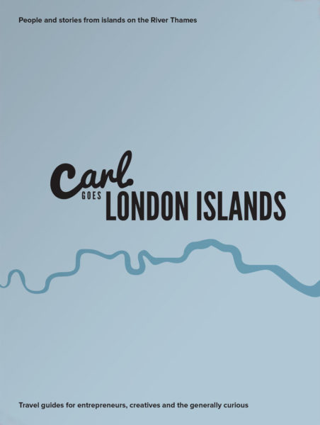
Maproom recently had the pleasure of providing map bases for a delightful new travel guide in the creative and distinctive Carl Goes series. The book, called Carl Goes London Islands, tells stories of the islands and islanders of the River Thames.

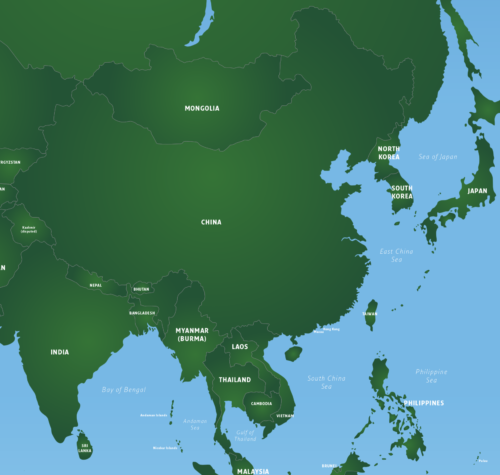
With Maproom’s parent company being Thameside Media, the River Thames is close to our studio literally and in our hearts. Not only that, we also have a special interest in travel guides, having published many ourselves over two decades (though never specifically for the Thames). Thus we were delighted to oblige when Sascha Mengerink, the Netherlands-based publisher of the Carl Goes series, asked Maproom if we could provide detailed map bases of the Thames Valley showing all the islands set within the River Thames between the mouth of the river at Canvey Island in Essex upriver through central London to the tiny eyots and aits in the Thames in Surrey and Berkshire. We were able to oblige with map bases using Ordnance Survey open data showing most of these small parcels of land overlooked by most other maps.

Oliver's Island - Carl Goes London Islands
Example pages within Carl Goes London Islands, showing a section of Maproom’s base map on the left-hand page, with Oliver’s Island marked in a circle. The delightful hand-drawn map on the right compliments the practical data map and is typical of the book – both factually informative and creatively quirky.

We were also excited to be invited to the book launch for Carl Goes London Islands, which was held – perfectly aptly – at the artists’ haunt of Eel Pie Island in the Thames by Twickenham. We met Sasha Arms, the affable, Esher-based author of Carl Goes London Islands, at the Open Day event, for which the artists based on Eel Pie Island welcome the public to visit their studios and purchase original artworks direct from source.

For Carl Goes London Islands, Sasha Arms spent months researching 65 islands along the River Thames. Many Londoners don’t know the islands exist, let alone that a number of them are inhabited. Home to musicians, artists, entrepreneurs, film industry experts, sports stars, business people – and many normal families too – the communities on London’s islands share something incredible. London’s islanders all have an affinity with the water and the drive to undertake an unconventional path in life.

Trevor Baylis - Carl Goes London Islands
Author Sasha Arms interviewed Trevor Baylis OBE CBE – inventor of the wind-up radio and resident of Eel Pie Island – before he passed away in March 2018.

Life by the river is revealed from shacks to mansions, with the life of idyll contrasting with the practical drawbacks, which can include having to park a long way from your house and, of course, flooding.

The Maproom and Thameside Media directors were already familiar with the Thames islands closest to our studio. Raven’s Ait at Surbiton is a familiar events venue, though we didn’t know its full history as covered in the book. We have skiffed past Boyle Farm Island, Swan Island and the residential Thames Ditton Island many times. One of our clients lives on a houseboat at Ash Island, where we discussed her business whilst being gently rocked by passing vessels. But the other 60+ islands in the Thames were a revelation to us reading the book. Indeed, we know of no other travel guide that includes these islands. Even the metadata on the OS base map that Maproom supplied for Carl Goes did not name some of the smallest islands in the Thames, so it was down to the publishers to identify the names of all the islands covered in this book.

Magna Carta Island - Carl Goes London Islands
Photographs are interspersed through the book, including this evocative image of tranquil Magna Carta Island.

Carl Goes London Islands is the sixth book in the Carl Goes series, following on from guides to Amsterdam, Berlin, Kassel, Leipzig and London. It is available to buy online at thamesislands.london (UK) and via a number of independent stockists.


Maproom sells editable vector artwork base maps on royalty free terms for digital and publishing projects. If you can’t find a suitable map base in our online shop, contact us for a bespoke map quote. We can supply a detailed map of any part of the UK and many other countries.

China is now censoring world maps

25 May 2018
Filed Under: Maproom News

China and surrounding countries on the Maproom world map

It has been brought to our attention that Chinese authorities are now subjecting world maps to a process of verification to ensure they conform to China’s sovereignty claims. For example, the depiction of disputed territories such as Taiwan and islands in the South China Sea and gas fields in the East China Sea must conform to Beijing’s official view. Map projection, affecting the size of China in comparison with the rest of the world, is also under scrutiny.

These restrictions affect all products sold in China, including maps on merchandise and within books, and they also affect maps printed in China on products destined for markets outside of China. The latter are now being impounded at Chinese customs whilst the authorities examine their origination and design.

Consequences for products deemed to violate Chinese sovereignty may include fines and the order for companies to withdraw and destroy products.

Recent cases include Gap being forced to apologise for selling T-shirts in North America with a map of China omitting Tibet and Taiwan (15/5/18), and Muji, the Japanese retailer, being fined £23k+ for labelling indoor drying racks as ‘Made in Taiwan’ (25/5/18).

At present, the only Maproom map that includes China is our Vector World Map, and this is affected by the restrictions described above. Our editable base map includes Taiwan in a compound path with China, and our examples supplied with the download package include Taiwan in the same colour as China. Tibet is not delineated separately from the rest of China. However, our world map is at a small scale that does not include all the small islands in disputed territories. The projection of this world map is WGS84, whereas map service providers in China are required to use a slightly different projection created by China. It is also possible for customers purchasing this map to easily colour Taiwan and other islands differently to mainland China, which will likely lead to problems on products being printed or sold in China, and may even cause a problem for products printed and sold outside of China, as in the Gap case mentioned above.

Given the situation, we strongly advise customers to avoid using Chinese printers to print world map products, nor to attempt selling world map products in China, and to make themselves aware of potential issues when colouring Taiwan and other disputed territories.

We will update this information if we learn of further developments.

Further reading:

www.scmp.com/news/china/economy/article/2146876/charts-why-chinese-publishers-dont-want-maps-their-books

www.businessinsider.com/r-new-chinese-map-gives-greater-play-to-south-china-sea-claims (includes China’s official map of China)

www.red24.com/members/intelligence/newsletters_security_briefings/south_china_sea_dispute (non-Chinese risk assessment company showing disputed territories in the South China Sea)

en.wikipedia.org/wiki/Restrictions_on_geographic_data_in_China

Only In Edinburgh – beautiful and erudite new travel guide using Maproom maps

13 December 2016
Filed Under: Maproom News, Travel Maps

edinburgh

Maproom’s parent company, Thameside Media, is closely associated with illustrated travel guides, having produced dozens of travel guides for different publishers over the years, including Eyewitness Japan, Blue Guide India, Real City Barcelona and Top 10 Algarve.

This is why we were especially delighted and only too pleased to oblige when Duncan J.D. Smith, knowledgeable author of the Only In travel guides, approached Maproom to build custom maps of Edinburgh and her environs for his well-researched new guide, Only In Edinburgh.

This guide is organised with thematic spreads delving into the more unexpected and unusual aspects of Scotland’s capital. So that, rather than a dry description of St Mary’s Metropolitan Cathedral, we leap into the story of Leith-born sculptor Eduardo Paolozzi, whose giant foot sculpture is installed in the cathedral forecourt. We trace J.K. Rowling’s coffee hangouts and speculate on the manifestation of the real George Heriot’s Castle, Lauriston, Raeburn and Greyfriars as the houses of Ravenclaw, Slytherin, Gryffindor and Hufflepuff in the Harry Potter novels. Fans of Ian Rankin’s Inspector Rebus are pointed to resources such as an app, tour guides and the Royal Oak pub at 1 Infirmary Street. A section titled A Poem in Glass and Stone turns out to be a 1999 structure housing the Scottish Poetry Library with its wealth of works in Scottish Gaelic, Lowland Scots and English. Another section, Where to Find a Million Pounds, piques further interest.

img_0647

There are over 100 such gems uncovered, each one elegantly penned by Smith, with accompanying high-quality colour photography and plotted with a numbered flag on our map base.

We thoroughly recommend the Only In series.

Only In Edinburgh: A Guide to Unique Locations, Hidden Corners and Unusual Objects, Duncan J.D. Smith (The Urban Explorer, ISBN 978-3-9504218-0-4, £16.95)
onlyinguides.com

Animated map of EU Countries, Schengen Area, Eurozone, Single Market and Hard Brexit

6 December 2016
Filed Under: Animated Maps, Maproom News


EU countries, Schengen, Eurozone, Single Market animated map

As a demo of what you can do with our base map of EU countries, we’ve created an animated map gif showing the current EU countries (2016-2019) layered with countries in the Eurozone, countries in the Schengen area, countries in the European Single Market and, finally, the European Single Market as it will look if the UK enacts a Hard Brexit.

The surprising story of Thomas Hardy in Surbiton – mapping the past

30 October 2016
Filed Under: Mapping the Past, Maproom News

Thomas Hardy
Thomas Hardy (image courtesy of the George Grantham Bain collection at the Library of Congress)

Hook Road in Surbiton is dotted with a few handsome villas that survive from the 1870s. One of these, a Victorian townhouse at number 15, bears a blue plaque for the famous novelist and poet Thomas Hardy.

It comes as a surprise to many to learn that Thomas Hardy was living in this vicinity in the mid-1870s. And perhaps even more surprising to know that Hardy’s famous novel, Far from the Madding Crowd, was published at the time he lived here in Surbiton. Age 33 and newly married to his wife, Emma, the couple were starting their married life in lodgings here. Far from the Madding Crowd was about to launch Thomas Hardy’s career.

A further point of interest for the neighbourhood is that Hardy wrote poems about Surbiton, Southborough and Long Ditton whilst living here.

History of the neighbourhood

Hardy’s home at St David’s Villa was one of a row of houses built circa 1872 on the Hook Road, then also known as Southborough Road. This was a turnpike road, and the row of villas stood near the Southborough turnpike toll gate at the junction of Ditton and Southborough Roads, by the Maypole Inn. The row of villas were new-builds at the time Hardy and his wife were living here in 1874-5. This whole area to the southwest of central Surbiton was called Southborough, stretching all the way to the southern hamlet of Hook and bordering Tolworth to the east, which at that time was undeveloped common land. What in modern times is the conservation heart of Southborough was in Hardy’s time still 200 acres of private parkland surrounding Southborough House, a mansion designed by the architect John Nash in 1808.

There were no house numbers on the Hook / Southborough Road during the Victorian era, but the modernday road numbering positions Hardy’s house at the location of 13 Hook Road. Sadly, St David’s Villa is no longer there. Most of the Victorian houses along the Hook Road, including Hardy’s house, were replaced by newer houses and blocks of flats in the intervening decades. St David’s Villa was demolished in 1960 and replaced with Midhurst Court. Presumably the proximity and contemporaneous age of 15 Hook Road next door to St David’s are why number 15 was renamed Hardy’s Villa on the Land Registry at some point.

The site of Hardy’s house, St David’s Villa, is where the corner of Midhurst Court now stands at 13 Hook Road. The neighbouring houses at numbers 15 (originally Devon Villa) and 17 Hook Road (originally Egerton Villa) are the only houses on the row to survive from Hardy’s era.

A blue plaque for Thomas Hardy at 15 Hook Road in Surbiton

Thomas Hardy blue plaque in Surbiton
A blue plaque at 15 Hook Road commemorates Thomas Hardy’s time in Surbiton

The location of St David’s Villa was identified by local historians Mark Davison and Colin Prendergast after two years of painstaking research, as detailed in the book Hook Remembered Again, published by Mark Davison in 2001. An image of Hardy’s house, photographed about 70 years after Hardy lived in it, appears in the book. Despite this hard-won discovery, the location remained largely obscure outside the vaults of the Kingston Local History Room for another 15 years until the blue plaque was installed.

Historic map showing St David’s Villa

Maproom has not been able to source a map of the Hook Road in Surbiton dating from the 1870s. However, we have found an Ordnance Survey map from 1898 (23 years after Hardy lived here), which shows the location of St David’s Villa. We have marked up this map indicating St David’s Villa in orange. The green buildings survive from Thomas Hardy’s era. All the other Hook Road buildings shown on this 1898 map, including Malvern Lodge, have either been replaced by blocks of flats, or were built after Hardy lived here.

Map of Thomas Hardy location in Surbiton

Far From the Madding Crowd …in Surbiton. Seriously?

Possibly the most surprising thing about finding out that Hardy was living here, is that he was living here in Surbiton at all. This seminal writer is enduringly associated with pastoral Dorset, not suburban London! Far from the Madding Crowd is a novel about social restrictions in rural Wessex, the book that propelled Hardy from obscurity as an architect and part-time writer to fame as one of the greatest novelists of his era.

Helping to explain why Hardy moved here, though, is Surbiton’s late 19th-century history as the Queen of the Suburbs, as it was known at the time. With a salubrious location downriver from Hampton Court, on well-frequented routes from Portsmouth and Brighton to the old royal palace, Surbiton was chosen for the routing of a new railway line from central London, with its new train station opening in 1863. Surbiton was rapidly expanding by the 1870s, with handsome Italianate villas and mansions being built for the merchant classes, hugely increasing the population from about 4,700 in 1860 to about 8,000 by the time Hardy moved here.

Hardy had been working in Arthur Blomfield’s architectural practice in London and was comfortable enough to honeymoon in Paris in September 1864, just before he came to live at St David’s Villa. According to Mark Davison, the author of Hook Remembered Again (published 2001), which has the greatest detail about Hardy’s time in Surbiton, Hardy almost certainly moved to Surbiton because of his friendship with a musician, Francis Honeywell, a friendship forged in Weymouth, where Hardy had worked as an architect, and where Honeywell’s family had a shop. Honeywell moved to Surbiton Park Terrace, opened a music shop and was the composer of The Surbiton Galop and the Hampton Court Quadrille. Hardy sometimes visited Honeywell and thus became familiar with the area.

Hardy moved to rented rooms at St David’s Villa in October 1874, sharing the five-bedroom property with William and Annie Hughes and their five-year-old daughter, also called Annie. Thomas Hardy’s wife, Emma, wrote in her diary for Tuesday 6th October: “St David’s Villa – Surbiton – 5-p.m. Annie & the Retriever playing in the garden with Papa.” Hardy was immediately busy preparing proofs of Far From the Madding Crowd, which was first published by Smith Elder & Co in November 1874, initially as a two-part novel. According to Davison, “Hardy and his wife, Emma, were delighted to discover educated ladies reading the book as they arrived in London by train from Surbiton the same month.”

Poster for the 2015 film version of Far From the Madding Crowd, starring Carey Mulligan and Michael Sheen

Thomas Hardy’s winter in Southborough, Surbiton

The winter of 1874-5 was exceptionally cold, and Hardy complained of the “abominable east winds” that whistled around St David’s Villa. In his notebook is a line Dec 19. 1874. Long Ditton. Snow on graves. A superfluous piece of cynicism in Nature. The graveyard is at St Mary’s Church in Long Ditton, which is just under a mile west of St David’s Villa.

Hardy, who considered himself foremost as a poet, only bothering to write novels to earn money, wrote the paired poems A Light Snow-Fall after Frost and Snow in the Suburbs whilst living in Southborough. The manuscript of the former states “Near Surbiton”.

A Light Snow-Fall after Frost

On the flat road a man at last appears:
How much his whitening hairs
Owe to the settling snow’s mute anchorage,
And how much to a life’s rough pilgrimage,
One cannot certify.
The frost is on the wane,
And cobwebs hanging close outside the pane
Pose as festoons of thick white worsted there,
Of their pale presence no eye being aware
Till the rime made them plain.
A second man comes by;
His ruddy beard brings fire to the pallid scene:
His coat is faded green;
Hence seems it that his mien
Wears something of the dye
Of the berried holm-trees that he passes nigh.

The snow-feathers so gently swoop that though
But half an hour ago
The road was brown, and now is starkly white,
A watcher would have failed defining quite
When it transformed it so.

Thomas Hardy, Southborough 1874-5

Snow in the Suburbs

Every branch big with it,
Bent every twig with it;
Every fork like a white web-foot;
Every street and pavement mute:
Some flakes have lost their way, and grope back upward when
Meeting those meandering down they turn and descend again.
The palings are glued together like a wall,
And there is no waft of wind with the fleecy fall.
A sparrow enters the tree,
Whereon immediately
A snow-lump thrice his own slight size
Descends on him and showers his head and eye
And overturns him,
And near inurns him,
And lights on a nether twig, when its brush
Starts off a volley of other lodging lumps with a rush.
The steps are a blanched slope,
Up which, with feeble hope,
A black cat comes, wide-eyed and thin;
And we take him in.

Thomas Hardy, Southborough 1874-5


The Story of Ethelberta

Illustrations by George Du Maurier from The Hand of Ethelberta, images courtesy of Philip V Allingham at the Victorian Web.

Hardy also started writing The Hand of Ethelberta: A Comedy in Chapters whilst living here. The story is set in both Dorset and London, and is a largely a satire on London society. It was serialised in the Cornhill Magazine in 1875, then published as a two-part novel in 1876. By the time it was published, Hardy and Emma had moved out of St David’s Villa, dividing their time over the next few years between short-term lodgings in Dorset and London.

4

Thomas Hardy’s life in locations

  • Birthplace 2nd June 1840: Higher Bockhampton, near Dorchester, Dorset. Hardy’s Cottage is a cob and thatch cottage surrounded by woodland and preserved by the National Trust
  • 1862–4: Worked with Arthur Blomfield on All Saints parish church, Windsor, Berkshire
  • 1863-74: 16 Westbourne Park Villas, Paddington, London
  • 1874-5: St David’s Villa, Southborough Road (now Hook Road), Surbiton
  • 1878-81: 172 Trinity Road, Tooting, London
  • 1885-11 January 1928: Max Gate, near Dorchester, Dorset, a substantial red-brick Queen Anne-style house Hardy built for himself and his first wife, Emma, in 1885, where he lived until his death from pleurisy in 1928. This is where Hardy wrote Tess of the d’Urbervilles, Jude the Obscure and The Mayor of Casterbridge. The Grade 1 listed house is preserved by the National Trust.
  • 16 January 1928: Thomas Hardy funeral at Westminster Abbey. His ashes were buried in Poet’s Corner, Westminster Abbey, whilst his heart is buried with his first wife, Emma, and other family members at St Michael’s Church, Stinsford, near Dorchester in Dorset.

Sources

Thomas Hardy: A Biography Revisited, Michael Millgate (Oxford University Press 2004; ISBN 0-19-927565)
Hook Remembered Again, Mark Davison (2001; ISBN 0-9534240-5-7)
Surbiton Past, Richard Statham (Biddles, 1996; ISBN 1-86077-026-6)

2,500 map plottings for Betjeman’s Best British Churches

11 January 2012
Filed Under: Bespoke Mapping Samples, Mapping the Past, Maproom News

Betjeman's Best British Churches

One of our greatest projects for Harper Collins publishers recently involved the mapping and photography of churches around Britain. Altogether we plotted the location of 2,500 churches using digital GPS data and translating it onto printed maps. It represents a massive achievement and huge improvement on the original black and white map bullets in the earlier editions of the book. With the OS and GPS coordinates given for people with SatNavs and mobile devices, Thameside Media is delighted to have had the opportunity to bring this classic work into the digital age.

Scotland maps in Betjeman's Best British Churches
Berkshire in Betjeman's Best British Churches
« Previous Page
Next Page »
  • Standard royalty free terms for downloadable maps
  • Licensing terms for downloadable postcode maps
  • Licensing terms for dynamic online maps
  • How to edit the downloadable maps
  • Refund, tax and pricing policies
  • Privacy & cookies

All content © Maproom at Blue Island Media · Award winning media projects