Maproom

Editable & interactive digital maps

  • about
  • news & blog
  • contact
  • 0 items
Log in
    • Home
  • Britain & Ireland maps
    • Britain and Ireland
    • UK - United Kingdom
    • Ireland
    • England
    • Scotland
    • Wales
    • Northern Ireland
    • Isle of Man
    • Channel Islands
  • City maps
    • Birmingham
    • Brighton
    • Bristol
    • Cardiff
    • Edinburgh
    • Exeter
    • Glasgow
    • Liverpool
    • London
    • Manchester
    • Oxford
  • Postcode maps
    • Overview
    • Dynamic postcode mapping tools
    • Downloadable postcode maps
  • Admin region maps
    • UK administrative regions
    • County maps
    • Local authority maps
    • London borough maps
    • Transport maps
    • National park maps
  • World maps
    • World maps
    • Europe maps
    • Map of EU countries 2024
    • Maps of France
    • Maps of Germany
    • Maps of New York and environs
  • DYNAMIC MAPPING
    • Showcase
    • Dynamic Mapping Suite information and demos
    • GET A PASS
  • Go bespoke
    • Bespoke mapping services
    • Bespoke static maps
    • Bespoke dynamic maps

New census mapping

27 July 2022
Filed Under: Interactive Mapping, Maproom News

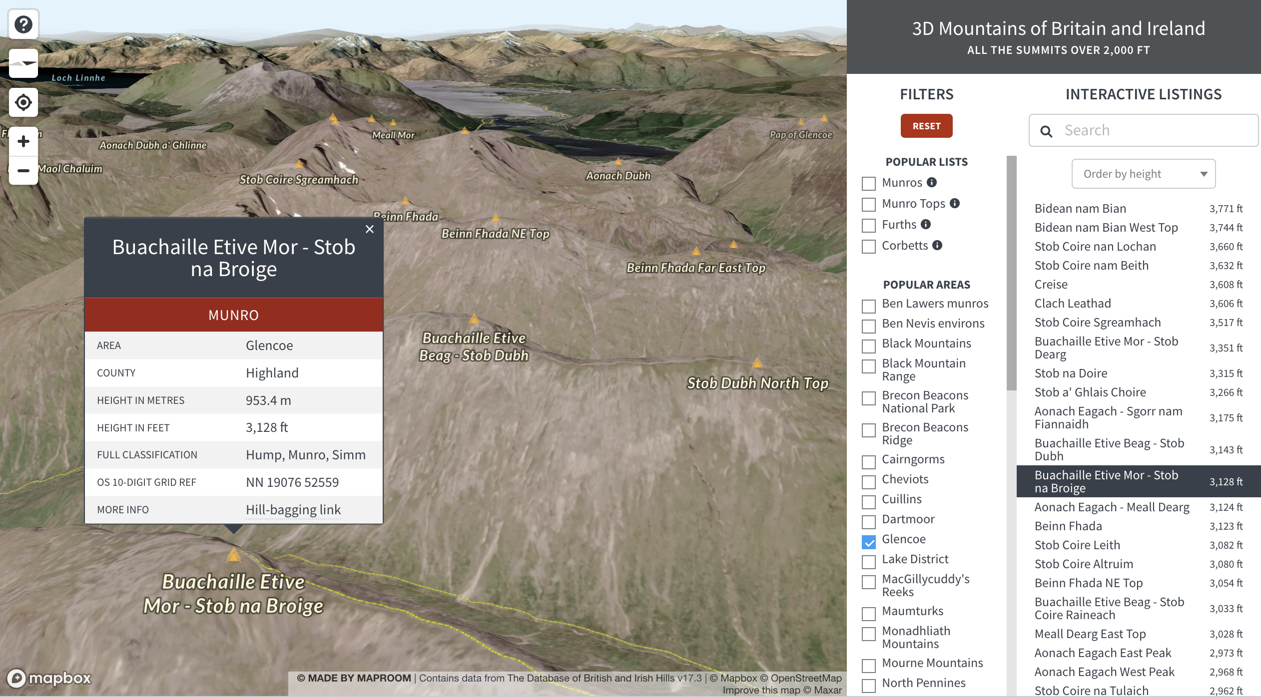
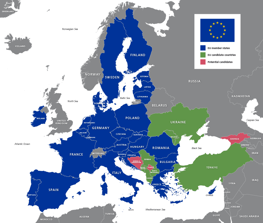
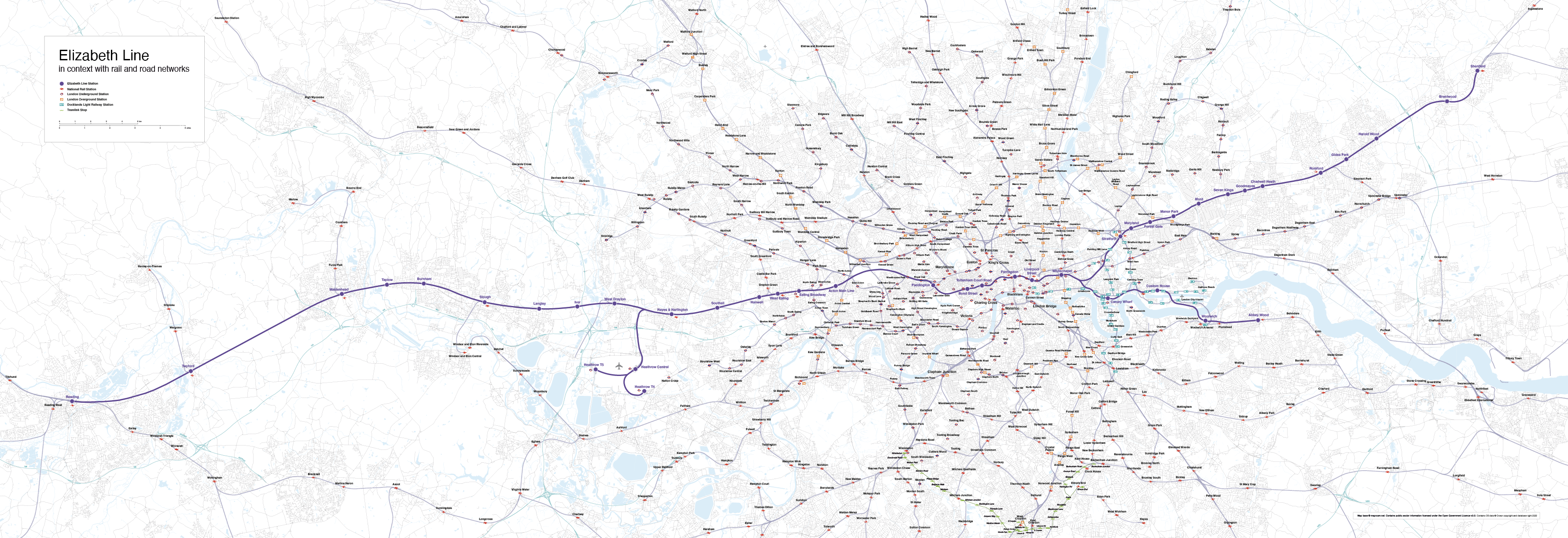
The Office for National Statistics has started to release data from the Census 2021. Below are some interactive England and Wales population maps that users can freely use on their own websites. Or commission us to create maps like these using other census data or marrying up census figures with your own data.

Hover or tap different parts of the maps for data interaction


Population change between 2011 and 2021, local authorities in England and Wales

Age structure of the population, 2021, local authorities in England and Wales

Population density, 2021 and changes since 2011, local authorities in England and Wales

Changes in the number of households between 2011 and 2021, local authorities in England and Wales

Our 3d map of British and Irish mountains is an immersive demo of new techniques with advanced satellite imagery and filters

21 July 2022
Filed Under: Interactive Mapping, Maproom News

Mapbox – our favourite dynamic mapping base system – released a new system based on Maxar satellite imagery last year, whereby geospatial developers such as us can tap into elevation and projection for satellite views layered with our own points, lines and polygons. We have experimented with the new 3d system in conjunction with our own techniques developed for listing and filtering, and come up with a rather sublime demo using data from The Database of British and Irish Hills.

Open full-size dynamic mountains map

Learn more about how we feed data to dynamic maps like this on the 3d mountains exploration demo page.

Europe and world maps updated for geopolitical events in 2022

20 July 2022
Filed Under: Maproom News

The United Nations have accepted Turkey’s official name spelling change to Türkiye with immediate effect, and Ukraine and Moldova have been accepted as EU candidate countries. Therefore we have updated our full set of Europe, EU and world maps to reflect these developments.

EU detailed map 2022 preview
Ukraine and Moldova are now EU candidate countries, and Turkey is now spelt Türkiye

Mapping the Elizabeth Line

14 July 2022
Filed Under: Maproom News

We were surprised to be contacted by quite a few people requesting a map showing the Elizabeth Line in geographical context. Like all of the UK’s official free rail maps, Transport for London’s map of the Elizabeth Line, available here, is meant for schematic visual clarity in route planning. It doesn’t attempt to show distances or other geospatial relationship. However, for town planners, property developers, marketeers and numerous other businesspeople and public sector organisations, it is useful to see the fuller picture of the Elizabeth Line. We have made the map for such people, and we have made it editable (ideally with Adobe Illustrator) and royalty free to use.

Purchase the new map on this product page: Elizabeth Line map with rail and road networks.

Elizabeth Line map with rail and road networks low-resolution preview
Preview image of our Elizabeth Line map showing geographical context all the way from Reading in the west to Shenfield in the east

Mapbox and Google Maps fees for high web traffic

30 May 2022
Filed Under: Interactive Mapping, Maproom News

At Maproom we build most of our interactive web maps on a Mapbox base. We also sometimes use Google Maps as a base. Both systems have their merits and weaknesses; both charge fees for high usage; and both are in a constant state of development and competition with each other and the smaller players on the dynamic mapping scene. Here’s a current comparison of Mapbox and Google Maps.

SystemProsCons
Mapbox – used to power reference maps in our Dynamic Mapping SuiteFar more customisable than Google Maps

Cheaper than Google Maps for high traffic

Various ways to handle large data feeds
No Streetview

Mediocre search

Not the highest resolution for satellite maps
Google Maps – used by us for some bespoke dynamic maps requiring Streetview or the highest resolution satellite imagery of LondonStreetview and the best search of all mapping systemsCompletely unable to handle advance styling or large data feeds

Usage

All web maps built with Mapbox and Google Maps are metered for usage. Usage means the number of times per month that a Google Map or Mapbox map is loaded. If, say, your website has a page with a Google Map embedded on it, the number of hits that page gets each month will count as the load.

Free tiers

Currently at the time of writing, the free threshold traffic for Google Maps is up to 28,500 loads per month, and for Mapbox it is up to 50,000 loads per month.

The majority of websites fall well below these thresholds and thus have free usage of the Google Maps and Mapbox bases upon which Maproom builds dynamic maps.

However, organisations with busy websites need to know about possible charges!

High traffic charges

(As at June 2022)

SystemCosts per 1,000 Monthly Map Loads
MapboxFREE up to 50,000 monthly map loads and 100,000 monthly search terms

$5 per 1,000 from 50,001 – 100,000 loads
$4 per 1,000 from 100,001 – 200,000 loads
$3 per 1,000 from 200,001 – 1,000,000 loads
negotiable from 1,000,000+ loads

More details at Mapbox pricing
Google MapsFREE up to 28,500 monthly map loads

$7 per 1,000 above 28,500 map loads
$14 per 1,000 for Street View
$5 per 1,000 search terms

More details at Google Maps pricing

The Dulwich Estate goes live with a public swipe-comparison map we built for them

27 May 2022
Filed Under: Interactive Mapping, Mapping the Past, Maproom News

Much of our interactive mapping work commissioned by clients is private – intended for an organisation’s internal use and therefore not available to show off as our work. However, one of the interactive maps we have built for The Dulwich Estate in south London is now displayed publicly on their website. A deep-zoom swipe map, it is intended to show thousands of Dulwich residents which properties and land is covered by The Dulwich Estate’s Scheme of Management. You can view the map embedded on their website here or the full-size version here.

The Dulwich Estate boundaries are based on historic mapping data which we had to examine in great detail, overlaying scans of old maps onto new digital ones. Swipe-comparison maps are a good solution when you want to compare historic with now. Another example is our Then and Now map of Whitechapel.

« Previous Page
Next Page »
  • Standard royalty free terms for downloadable maps
  • Licensing terms for downloadable postcode maps
  • Licensing terms for dynamic online maps
  • How to edit the downloadable maps
  • Pricing & refund policies
  • Privacy & cookies

All content © Maproom at Blue Island Media · Award winning media projects