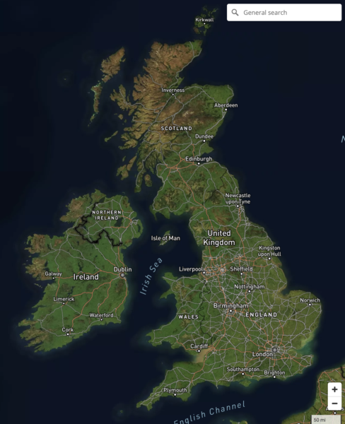
View full size map See our showcase of dynamic, interactive online maps for more about this type of route map that we can build for you.

![]()
Interactive & editable digital maps
View full size map See our showcase of dynamic, interactive online maps for more about this type of route map that we can build for you.

Hugely upgraded Locations Plotter and Quick Select Postcodes now with Sector colouring. Live Views can be shared with password protection.
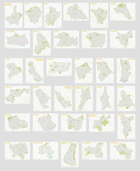
All 33 London borough maps are now available individually or in a discounted bundle set. Scaled for legibility at A1, they show a wealth of detail and isolate the shape of each borough with a semi-transparent mask. Supplied in PDF, SVG and Adobe Illustrator formats, they are perfect for use as they are, or for …READ MORE…

We were pleased to see Maproom’s Greater London map base put to good use within this week’s episode of Silent Witness. (All of our downloadable maps can be used for set dressing and TV graphics.) Here, the fictional pathologists are plotting points and trails in Southeast London to help catch a serial killer.
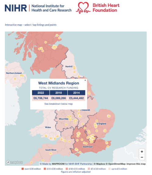
We are delighted to publish two bespoke interactive maps for the NIHR-British Heart Foundation Partnership, which show the funding regions and member centres for millions of pounds worth of cardiovascular research in the UK. The maps took several months to compile data for and programmed as native embeds on the Oxford Biomedical Research Centre website.
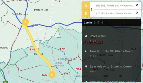
We’ve added an auto-calculating A to B driving route plotter with directions for businesses that need to calculate service charge areas and delivery routes in and around the UK’s Low Emission Zones. See at a glance if your customer’s postcode is in a Low Emission Zone and / or if your route takes you into …READ MORE…

We have updated all our Local Authority map bases in line with changes that have come into effect on 1 April 2023. As far as we can see, we have actually beaten the Government itself in issuing the new boundary data! The changes are as follows: Cumberland – formerly Allerdale, Carlisle, Copeland Westmorland and Furness – formerly …READ MORE…
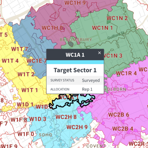
A powerful yet easy to use system of connecting spreadsheets to colour and label polygon maps is now available in our Dynamic Mapping Suite, and it costs only a very modest £35 to use. Currently available for dynamically colouring and captioning from spreadsheet: See a live example of a postcode district polygons map connected to …READ MORE…
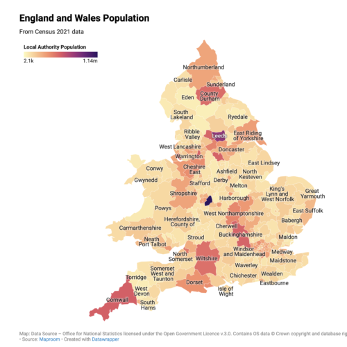
The Office for National Statistics has started to release data from the Census 2021. Below are some interactive England and Wales population maps that users can freely use on their own websites. Or commission us to create maps like these using other census data or marrying up census figures with your own data. Hover or …READ MORE…
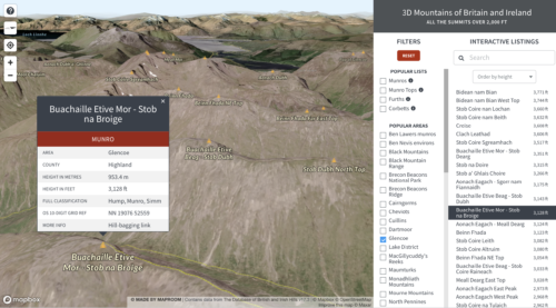
Mapbox – our favourite dynamic mapping base system – released a new system based on Maxar satellite imagery last year, whereby geospatial developers such as us can tap into elevation and projection for satellite views layered with our own points, lines and polygons. We have experimented with the new 3d system in conjunction with our …READ MORE…
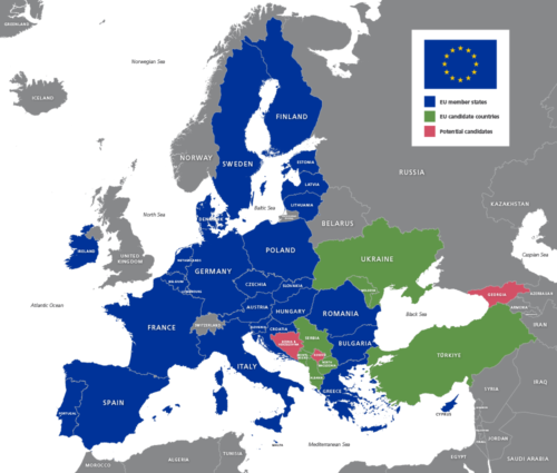
The United Nations have accepted Turkey’s official name spelling change to Türkiye with immediate effect, and Ukraine and Moldova have been accepted as EU candidate countries. Therefore we have updated our full set of Europe, EU and world maps to reflect these developments.
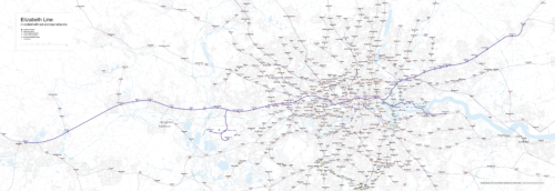
We were surprised to be contacted by quite a few people requesting a map showing the Elizabeth Line in geographical context. Like all of the UK’s official free rail maps, Transport for London’s map of the Elizabeth Line, available here, is meant for schematic visual clarity in route planning. It doesn’t attempt to show distances …READ MORE…
At Maproom we build most of our interactive web maps on a Mapbox base. We also sometimes use Google Maps as a base. Both systems have their merits and weaknesses; both charge fees for high usage; and both are in a constant state of development and competition with each other and the smaller players on …READ MORE…
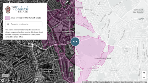
Much of our interactive mapping work commissioned by clients is private – intended for an organisation’s internal use and therefore not available to show off as our work. However, one of the interactive maps we have built for The Dulwich Estate in south London is now displayed publicly on their website. A deep-zoom swipe map, …READ MORE…
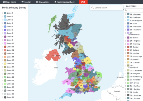
If we hadn’t been so busy with the pandemic and Brexit-related work in 2020, we would have launched the new Quick Select editing system months ago! Anyhow, it’s finally landed – the ability to colour your postcode maps simply with point and click colouring. The system is available with a premium pass for our Dynamic …READ MORE…
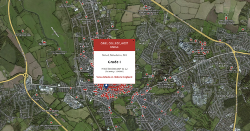
We’ve been busy in lockdown and built a wonderful interactive map of listed buildings in England. The first thing we did after flowing in the data was to look up listed buildings in our own neighbourhood. What will you find in your own areas of interest? The map is a demo of how we can …READ MORE…
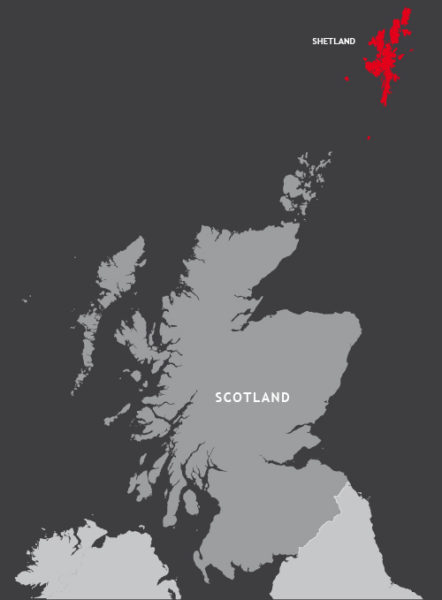
Today a new law brought by the Islands (Scotland) Bill has come into force to ban public bodies from using maps that display Shetland in a box rather than in its natural geographic position 150 miles north of the Scottish mainland. The BBC article about the law, instigated by Islands Lib Dem MSP Tavish Scott and …READ MORE…
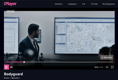
Maproom maps are popular with TV production companies, and we were pleased to spot our London Street Map being used to good effect in the new BBC series Bodyguard last night. Our map appears in a scene in which actor Gina McKee, playing Commander Anne Sampson of the Metropolitan Police’s Counter Terrorism Command, has a team …READ MORE…
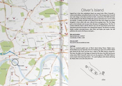
Maproom recently had the pleasure of providing map bases for a delightful new travel guide in the creative and distinctive Carl Goes series. The book, called Carl Goes London Islands, tells stories of the islands and islanders of the River Thames. With Maproom’s parent company being Thameside Media, the River Thames is close to our studio …READ MORE…
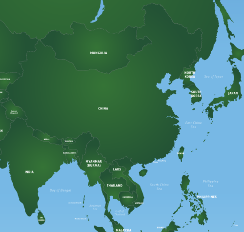
It has been brought to our attention that Chinese authorities are now subjecting world maps to a process of verification to ensure they conform to China’s sovereignty claims. For example, the depiction of disputed territories such as Taiwan and islands in the South China Sea and gas fields in the East China Sea must conform to …READ MORE…

Maproom’s parent company, Thameside Media, is closely associated with illustrated travel guides, having produced dozens of travel guides for different publishers over the years, including Eyewitness Japan, Blue Guide India, Real City Barcelona and Top 10 Algarve. This is why we were especially delighted and only too pleased to oblige when Duncan J.D. Smith, knowledgeable author …READ MORE…
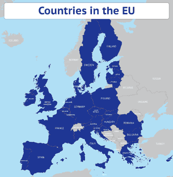
As a demo of what you can do with our base map of EU countries, we’ve created an animated map gif showing the current EU countries (2016-2019) layered with countries in the Eurozone, countries in the Schengen area, countries in the European Single Market and, finally, the European Single Market as it will look …READ MORE…
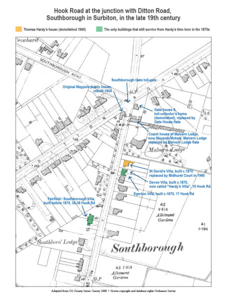
Hook Road in Surbiton is dotted with a few handsome villas that survive from the 1870s. One of these, a Victorian townhouse at number 15, bears a blue plaque for the famous novelist and poet Thomas Hardy. It comes as a surprise to many to learn that Thomas Hardy was living in this vicinity in …READ MORE…

One of our greatest projects for Harper Collins publishers recently involved the mapping and photography of churches around Britain. Altogether we plotted the location of 2,500 churches using digital GPS data and translating it onto printed maps. It represents a massive achievement and huge improvement on the original black and white map bullets in the …READ MORE…
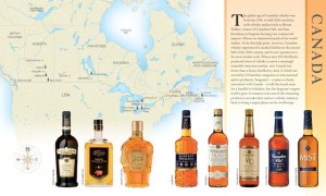
The owners of Maproom are proud to announce that our World Whisky project has won the IACP award for Best Cookbook. The publication, published by DK, involved us mapping all the whisky-producing nations of the world as well as photographing literally hundreds of the finest whiskies ever produced. For more about our award-winning media projects …READ MORE…