Maproom

Editable & interactive digital maps

MENUMENU
  • about
  • news & blog
  • contact
  • 0 items
LOGIN
    • Home
  • Britain & Ireland maps
    • Britain and Ireland
    • UK - United Kingdom
    • Ireland
    • England
    • Scotland
    • Wales
    • Northern Ireland
    • Isle of Man
    • Channel Islands
  • City maps
    • Birmingham
    • Brighton
    • Bristol
    • Cardiff
    • Edinburgh
    • Exeter
    • Glasgow
    • Liverpool
    • London
    • Manchester
    • Oxford
  • Postcode maps
    • Overview
    • Online postcode mapping tools
    • Downloadable postcode maps
  • Region maps
    • Region maps
    • County maps
    • Local authority maps
    • Transport maps
    • National park maps
  • World maps
    • World maps
    • Europe maps
    • Map of EU countries 2024
    • Maps of France
    • Maps of Germany
    • Maps of New York and environs
  • DYNAMIC
    • Showcase
    • Dynamic Mapping Suite information and demos
    • GET A PASS
  • BESPOKE
    • Bespoke mapping services
    • Bespoke static maps
    • Bespoke dynamic maps
    • Search

General Advice About Vector Artwork

  • How to edit the downloadable maps
  • Editing colours
  • Scaling recommendations
  • Dealing with text
  • About hillshading layers
  • Outputting for websites or apps
  • Outputting for print

Illustrator Tutorials

  • Understanding the map layers
  • Special option layers
  • Advanced editing of strokes in Illustrator
  • Video – How to use the map layers in Illustrator
  • Video – how to change map colours in Illustrator

Photoshop Tutorials

  • How to change the colour of a hillshading / relief layer in Photoshop

Customisation service

We offer a range of services if you need help to customise your map. Our rates are competitive and we will waive the price of the base map itself if you have already purchased one.

See bespoke services

Scaling recommendations

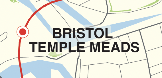
A vector art image can be scaled to any size and remain sharp.

100%
200%
400%

However, we recommend you keep within the dimensions suggested under ‘Specifications’ for our downloadable vector art products.

Some of our maps are scaled specifically for A-format print sizes, and we specify the minimum print size, e.g. A4 or A3, at which the smallest labels are guaranteed to be legible when printed.

Maps with a lot of text will be difficult to scale smaller than the recommended size in terms of legibility. However, you can turn off text layers easily in Adobe Illustrator if labels start to crash into each other.

Blowing up larger than about 500% of the initial size of your map file may compromise the accuracy and integrity of coastlines, roads and other details.

We sell a few maps with relief / hillshading layers generated from pixel (raster) art. These have limited zoom capabilities and the relief backdrop will look fuzzy if blown up big, which is why the scaling recommendations on relief maps are lower than on all the other maps.

  • Standard royalty free terms for downloadable maps
  • Licensing terms for downloadable postcode maps
  • Licensing terms for dynamic online maps
  • How to edit the downloadable maps
  • Pricing & refund policies
  • Privacy & cookies

All content © Maproom at Blue Island Media · Award winning media projects