Showing 1–150 of 179 results
-

UK Local Authorities + Postcodes Map from April 2023
£60.00UK Local Authorities juxtaposed with postcodes districts, plus a Limited Free Pass for the Dynamic Mapping Suite giving access to online Local Authority maps and mapping tools.
PDFSVGLayered AI file -
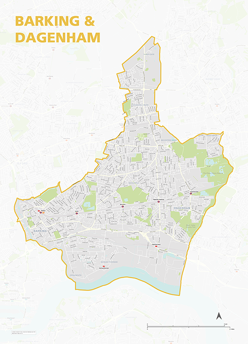
Barking & Dagenham – London borough map
£40.00Map of the London Borough of Barking and Dagenham, detailing the road and public transport network, as well as parks and other open areas. Designed for A1+ printing or editing for other uses.
PDFSVGLayered AI file -
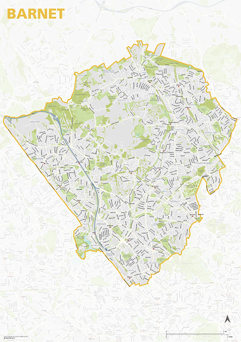
Barnet – London borough map
£40.00Map of the London Borough of Barnet, detailing the road and public transport network, as well as parks and other open areas. Designed for A1+ printing or editing for other uses.
PDFSVGLayered AI file -
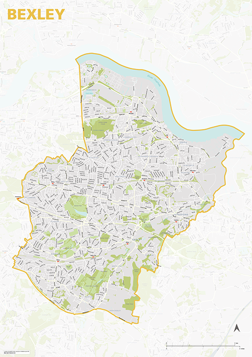
Bexley – London borough map
£40.00Map of the London Borough of Bexley, detailing the road and public transport network, as well as parks and other open areas. Designed for A1+ printing or editing for other uses.
PDFSVGLayered AI file -
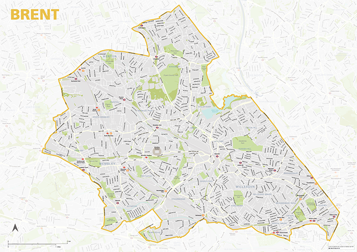
Brent – London borough map
£40.00Map of the London Borough of Brent, detailing the road and public transport network, as well as parks and other open areas. Designed for A1+ printing or editing for other uses.
PDFSVGLayered AI file -
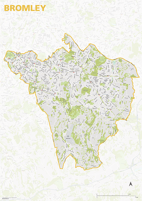
Bromley – London borough map
£40.00Map of the London Borough of Brent, detailing the road and public transport network, as well as parks and other open areas. Designed for A1+ printing or editing for other uses.
PDFSVGLayered AI file -

Camden – London borough map
£40.00Map of the London Borough of Camden, detailing the road and public transport network, as well as parks and other open areas. Designed for A1+ printing or editing for other uses.
PDFSVGLayered AI file -
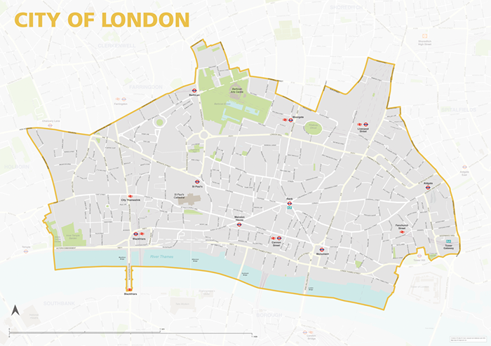
City of London – borough style map
£40.00Map of the City of London, detailing the road and public transport network, as well as park squares and other open areas. Designed for A1+ printing or editing for other uses.
PDFSVGLayered AI file -
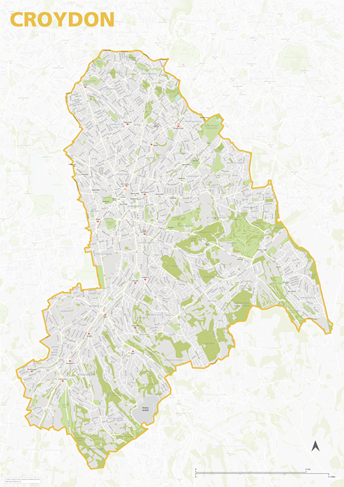
Croydon – London borough map
£40.00Map of the London Borough of Croydon, detailing the road and public transport network, as well as parks and other open areas. Designed for A1+ printing or editing for other uses.
PDFSVGLayered AI file -
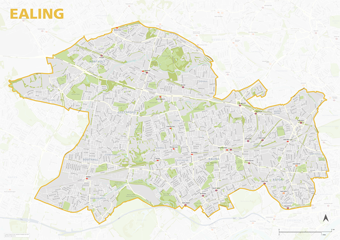
Ealing – London borough map
£40.00Map of the London Borough of Ealing, detailing the road and public transport network, as well as parks and other open areas. Designed for A1+ printing or editing for other uses.
PDFSVGLayered AI file -
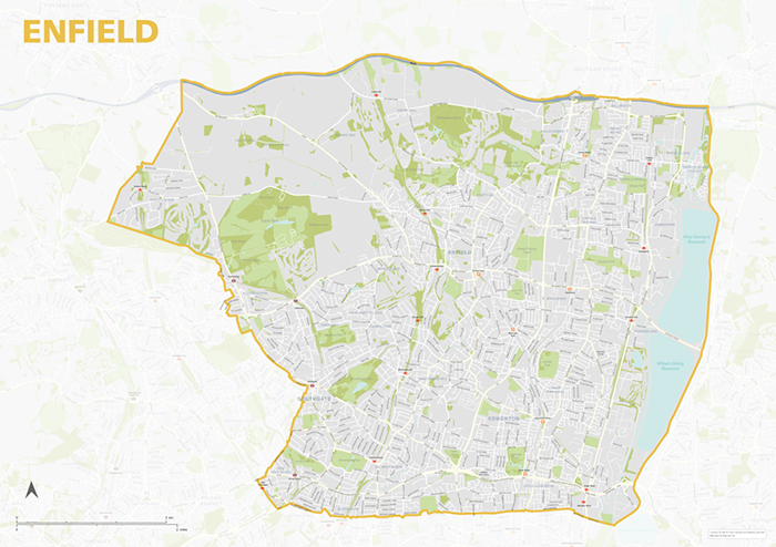
Enfield – London borough map
£40.00Map of the London Borough of Enfield, detailing the road and public transport network, as well as parks and other open areas. Designed for A1+ printing or editing for other uses.
PDFSVGLayered AI file -
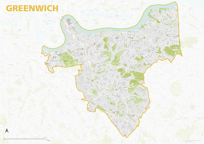
Greenwich – London borough map
£40.00Map of the London Borough of Greenwich, detailing the road and public transport network, as well as parks and other open areas. Designed for A1+ printing or editing for other uses.
PDFSVGLayered AI file -
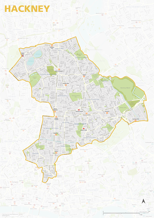
Hackney – London borough map
£40.00Map of the London Borough of Hackney, detailing the road and public transport network, as well as parks and other open areas. Designed for A1+ printing or editing for other uses.
PDFSVGLayered AI file -
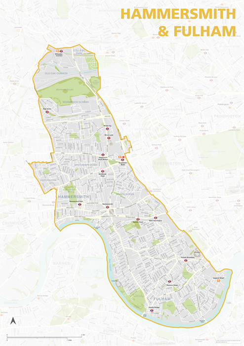
Hammersmith & Fulham – London borough map
£40.00Map of the London Borough of Hammersmith & Fulham, detailing the road and public transport network, as well as parks and other open areas. Designed for A1+ printing or editing for other uses.
PDFSVGLayered AI file -
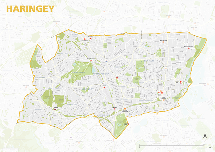
Haringey – London borough map
£40.00Map of the London Borough of Haringey, detailing the road and public transport network, as well as parks and other open areas. Designed for A1+ printing or editing for other uses.
PDFSVGLayered AI file -
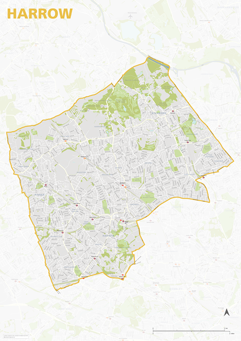
Harrow – London borough map
£40.00Map of the London Borough of Harrow, detailing the road and public transport network, as well as parks and other open areas. Designed for A1+ printing or editing for other uses.
PDFSVGLayered AI file -
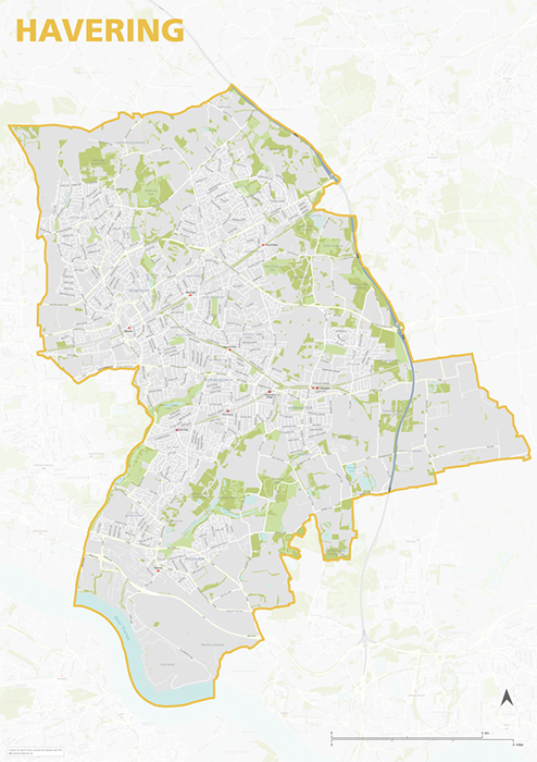
Havering – London borough map
£40.00Map of the London Borough of Havering, detailing the road and public transport network, as well as parks and other open areas. Designed for A1+ printing or editing for other uses.
PDFSVGLayered AI file -
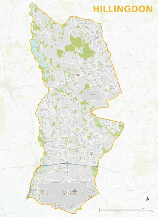
Hillingdon – London borough map
£40.00Map of the London Borough of Hillingdon, detailing the road and public transport network, as well as parks and other open areas. Designed for A1+ printing or editing for other uses.
PDFSVGLayered AI file -
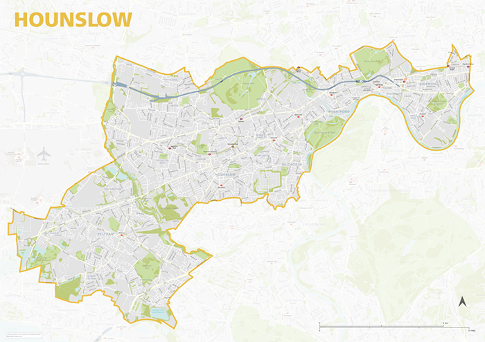
Hounslow – London borough map
£40.00Map of the London Borough of Hounslow, detailing the road and public transport network, as well as parks and other open areas. Designed for A1+ printing or editing for other uses.
PDFSVGLayered AI file -
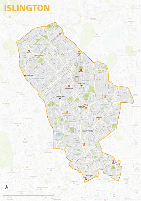
Islington – London borough map
£40.00Map of the London Borough of Islington, detailing the road and public transport network, as well as parks and other open areas. Designed for A1+ printing or editing for other uses.
PDFSVGLayered AI file -
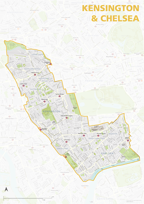
Kensington & Chelsea – London borough map
£40.00Map of the London Borough of Kensington & Chelsea, detailing the road and public transport network, as well as parks and other open areas. Designed for A1+ printing or editing for other uses.
PDFSVGLayered AI file -
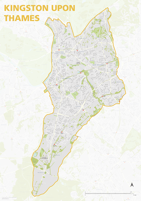
Kingston upon Thames – London borough map
£40.00Map of the London Borough of Kingston upon Thames, detailing the road and public transport network, as well as parks and other open areas. Designed for A1+ printing or editing for other uses.
PDFSVGLayered AI file -
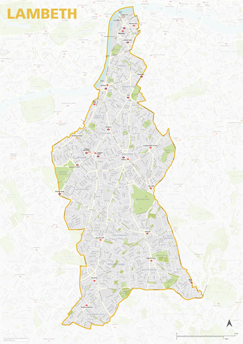
Lambeth – London borough map
£40.00Map of the London Borough of Lambeth, detailing the road and public transport network, as well as parks and other open areas. Designed for A1+ printing or editing for other uses.
PDFSVGLayered AI file -
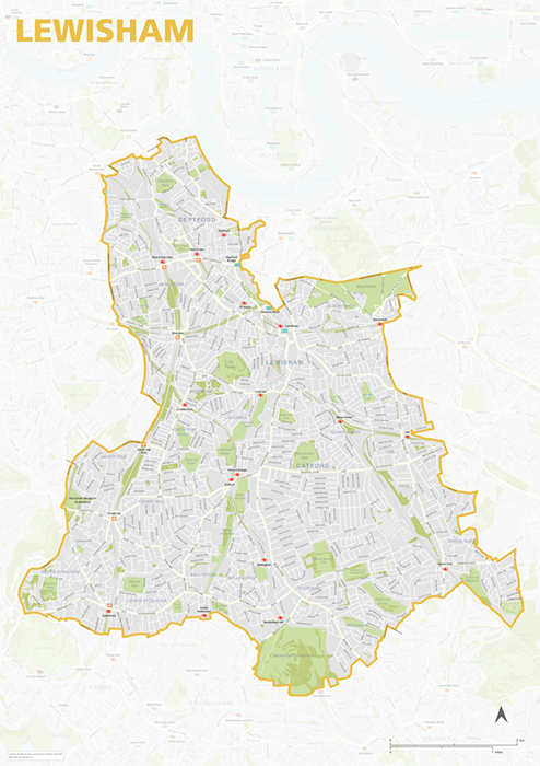
Lewisham – London borough map
£40.00Map of the London Borough of Lewisham, detailing the road and public transport network, as well as parks and other open areas. Designed for A1+ printing or editing for other uses.
PDFSVGLayered AI file -
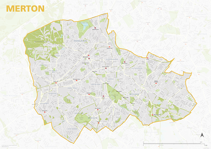
Merton – London borough map
£40.00Map of the London Borough of Merton, detailing the road and public transport network, as well as parks and other open areas. Designed for A1+ printing or editing for other uses.
PDFSVGLayered AI file -
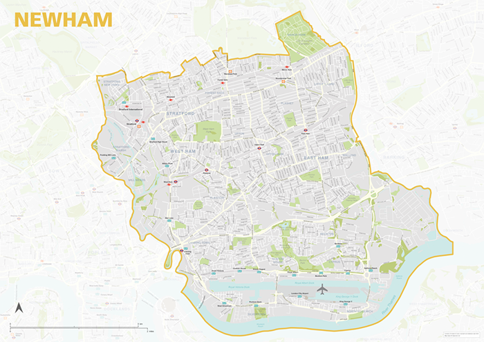
Newham – London borough map
£40.00Map of the London Borough of Newham, detailing the road and public transport network, as well as parks and other open areas. Designed for A1+ printing or editing for other uses.
PDFSVGLayered AI file -
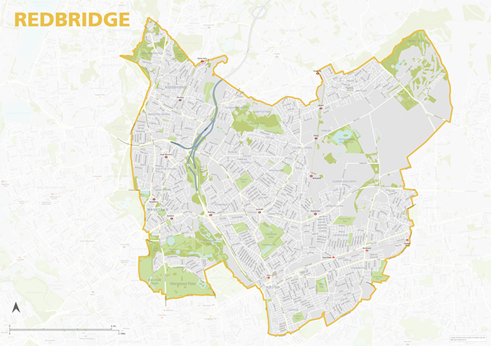
Redbridge – London borough map
£40.00Map of the London Borough of Redbridge, detailing the road and public transport network, as well as parks and other open areas. Designed for A1+ printing or editing for other uses.
PDFSVGLayered AI file -
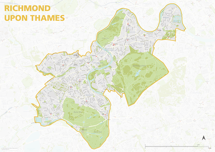
Richmond upon Thames – London borough map
£40.00Map of the London Borough of Richmond upon Thames, detailing the road and public transport network, as well as parks and other open areas. Designed for A1+ printing or editing for other uses.
PDFSVGLayered AI file -
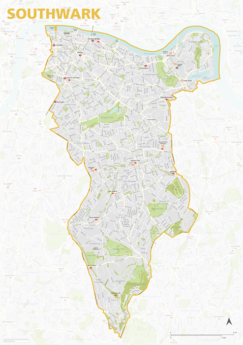
Southwark – London borough map
£40.00Map of the London Borough of Southwark, detailing the road and public transport network, as well as parks and other open areas. Designed for A1+ printing or editing for other uses.
PDFSVGLayered AI file -
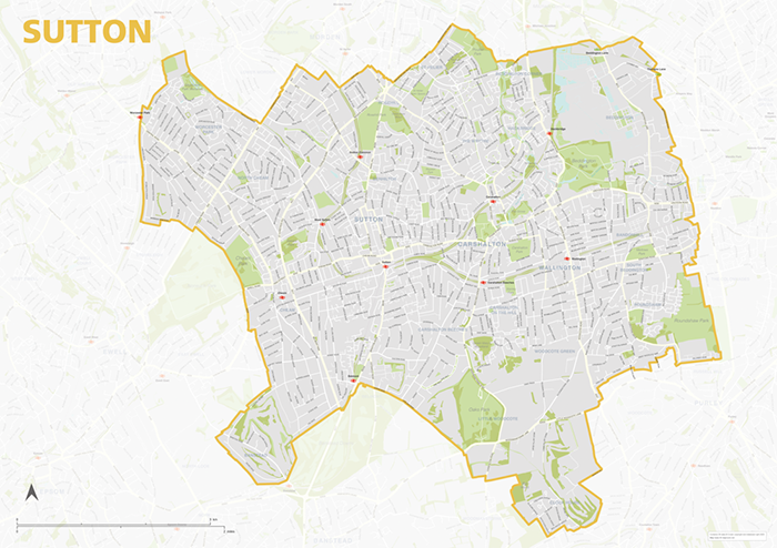
Sutton – London borough map
£40.00Map of the London Borough of Sutton, detailing the road and public transport network, as well as parks and other open areas. Designed for A1+ printing or editing for other uses.
PDFSVGLayered AI file -
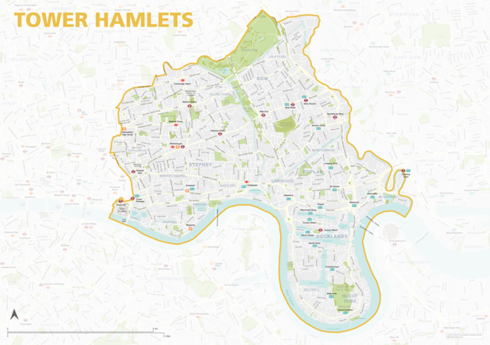
Tower Hamlets – London borough map
£40.00Map of the London Borough of Tower Hamlets, detailing the road and public transport network, as well as parks and other open areas. Designed for A1+ printing or editing for other uses.
PDFSVGLayered AI file -
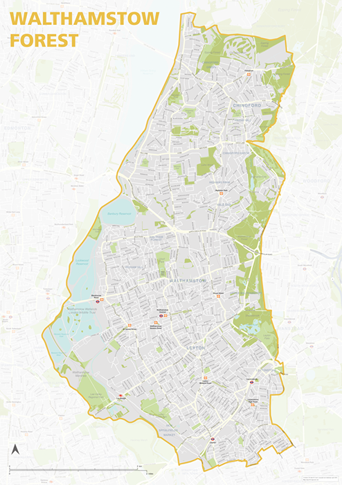
Waltham Forest – London borough map
£40.00Map of the London Borough of Tower Hamlets, detailing the road and public transport network, as well as parks and other open areas. Designed for A1+ printing or editing for other uses.
PDFSVGLayered AI file -
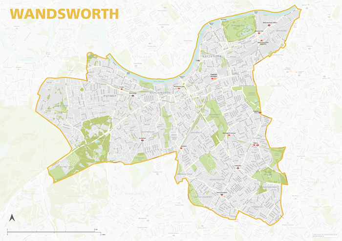
Wandsworth – London borough map
£40.00Map of the London Borough of Wandsworth, detailing the road and public transport network, as well as parks and other open areas. Designed for A1+ printing or editing for other uses.
PDFSVGLayered AI file -
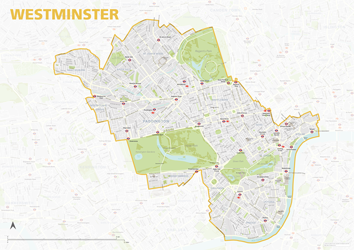
Westminster – London borough map
£40.00Map of the London Borough of Westminster, detailing the road and public transport network, as well as parks and other open areas. Designed for A1+ printing or editing for other uses.
PDFSVGLayered AI file -
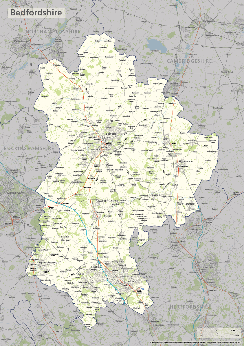
Bedfordshire county map
£40.00The ceremonial county of Bedfordshire is highlighted along with towns, villages, roads, railway lines, lakes, rivers, woodland and green spaces. Scaled for A3+ printing
PDFSVGLayered AI file -
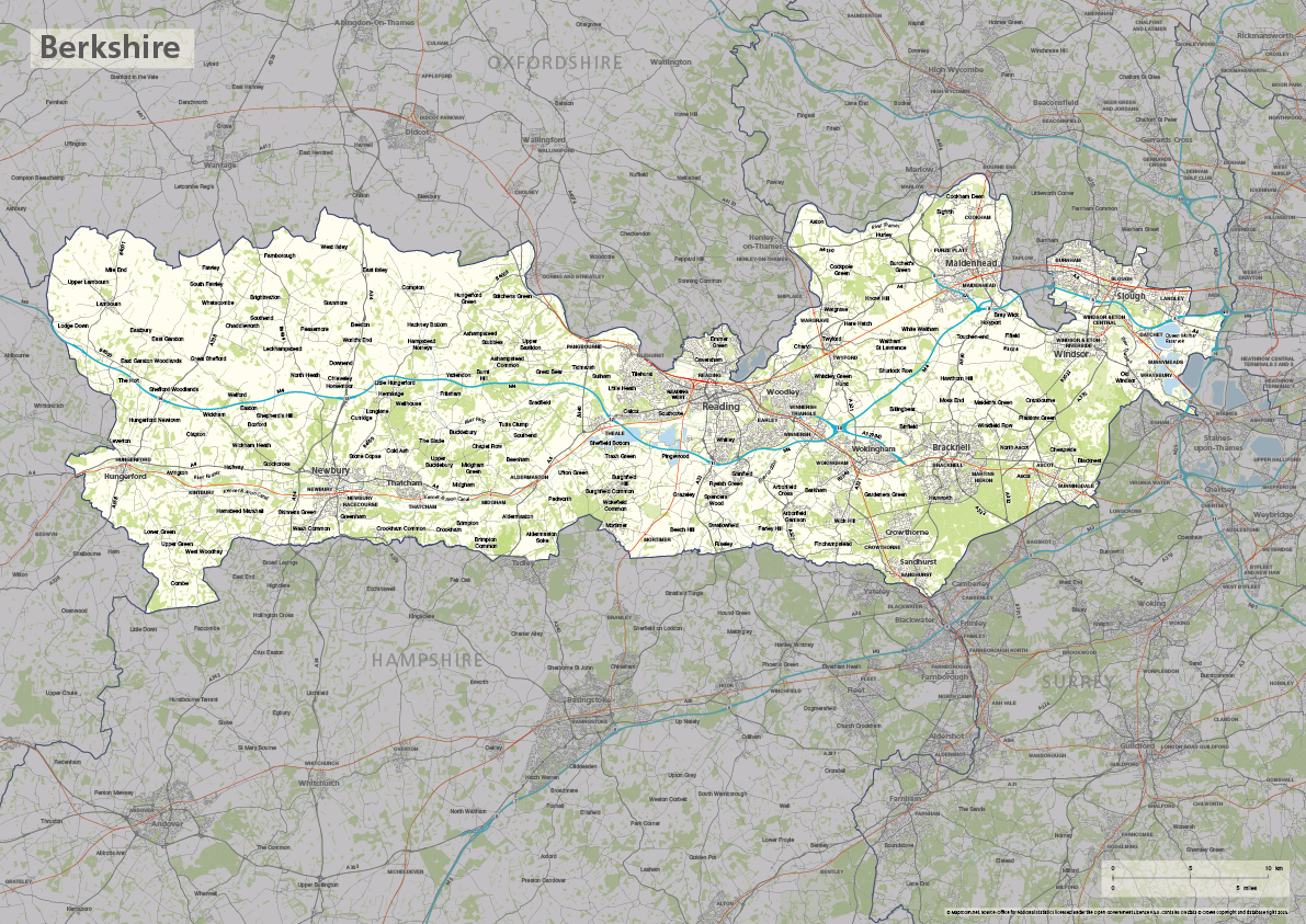
Berkshire county map
£40.00The ceremonial county of Berkshire is highlighted along with towns, villages, roads, railway lines, lakes, rivers, woodland and green spaces. Scaled for A3+ printing
PDFSVGLayered AI file -
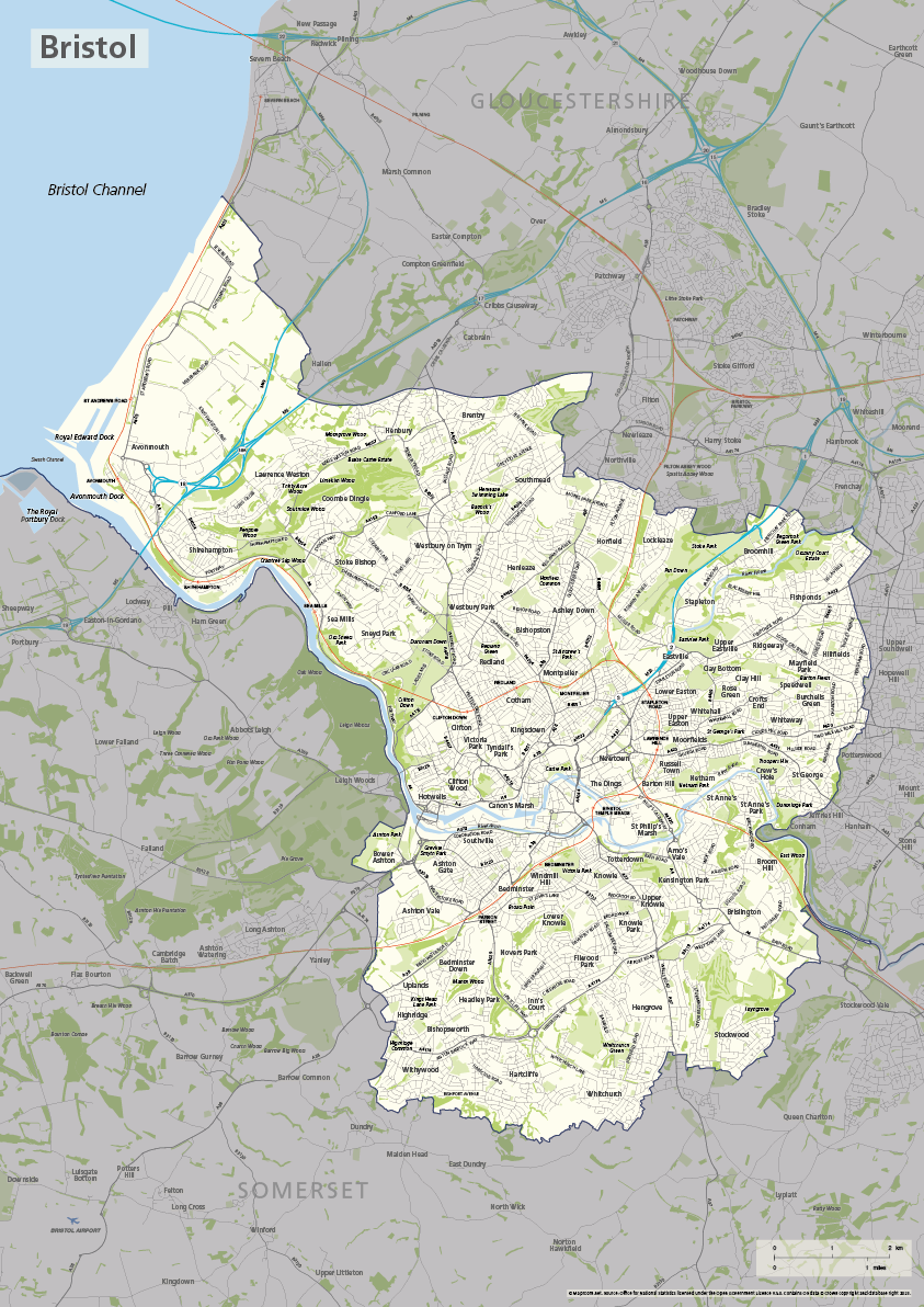
Bristol county map
£40.00The ceremonial county / unitary authority of Bristol is highlighted along with towns, villages, roads, railway lines, lakes, rivers, woodland and green spaces. Scaled for A3+ printing
PDFSVGLayered AI file -

Buckinghamshire county map
£40.00The ceremonial county of Buckinghamshire is highlighted along with towns, villages, roads, railway lines, lakes, rivers, woodland and green spaces. Scaled for A3+ printing
PDFSVGLayered AI file -
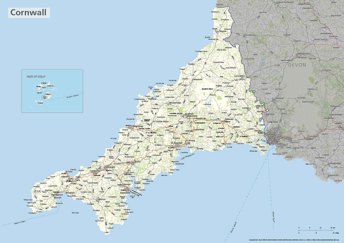
Cornwall county map with Isles of Scilly
£40.00The ceremonial county of Cornwall is highlighted along with towns, villages, roads, railway lines, lakes, rivers, woodland and green spaces. The Isles of Scilly are optionally shown in their natural geographic position or in an inset box. Scaled for A3+ printing
PDFSVGLayered AI file -

Devon county map
£40.00The ceremonial county of Devon is highlighted along with towns, villages, roads, railway lines, lakes, rivers, woodland and green spaces. Scaled for A3+ printing
PDFSVGLayered AI file -
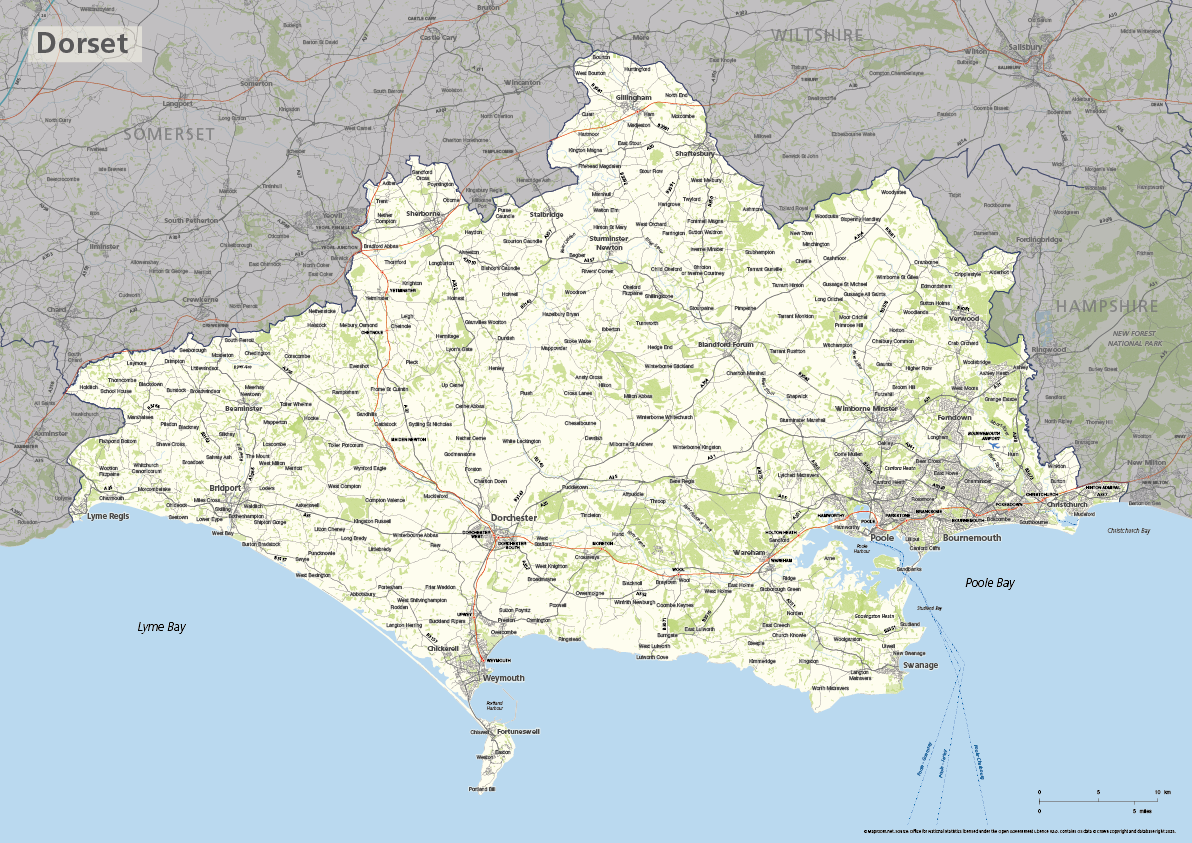
Dorset county map
£40.00The ceremonial county of Dorset is highlighted along with towns, villages, roads, railway lines, lakes, rivers, woodland and green spaces. Scaled for A3+ printing
PDFSVGLayered AI file -
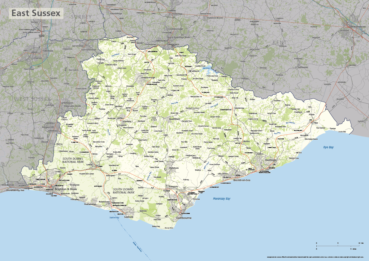
East Sussex county map
£40.00The ceremonial county of East Sussex is highlighted along with towns, villages, roads, railway lines, lakes, rivers, woodland and green spaces. Scaled for A3+ printing
PDFSVGLayered AI file -
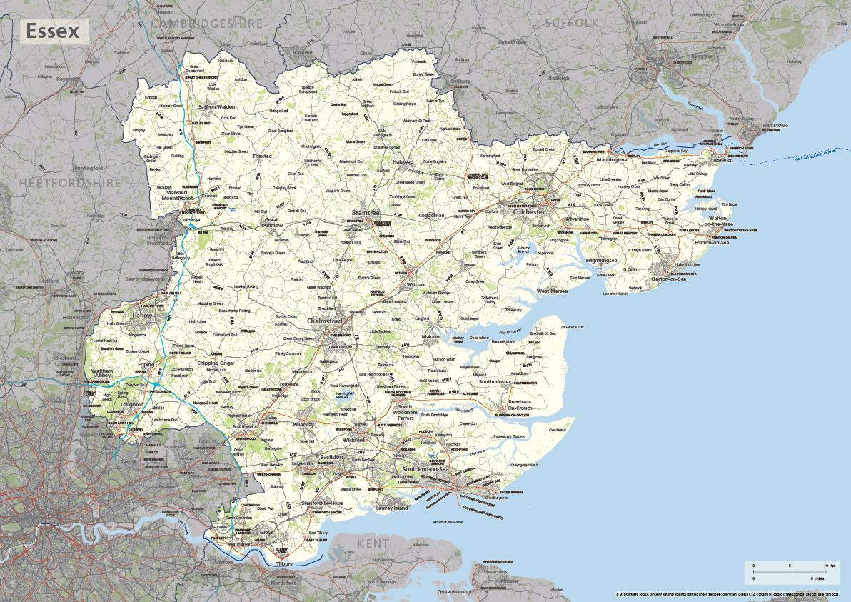
Essex county map
£40.00The ceremonial county of Essex is highlighted along with towns, villages, roads, railway lines, lakes, rivers, woodland and green spaces. Scaled for A3+ printing
PDFSVGLayered AI file -
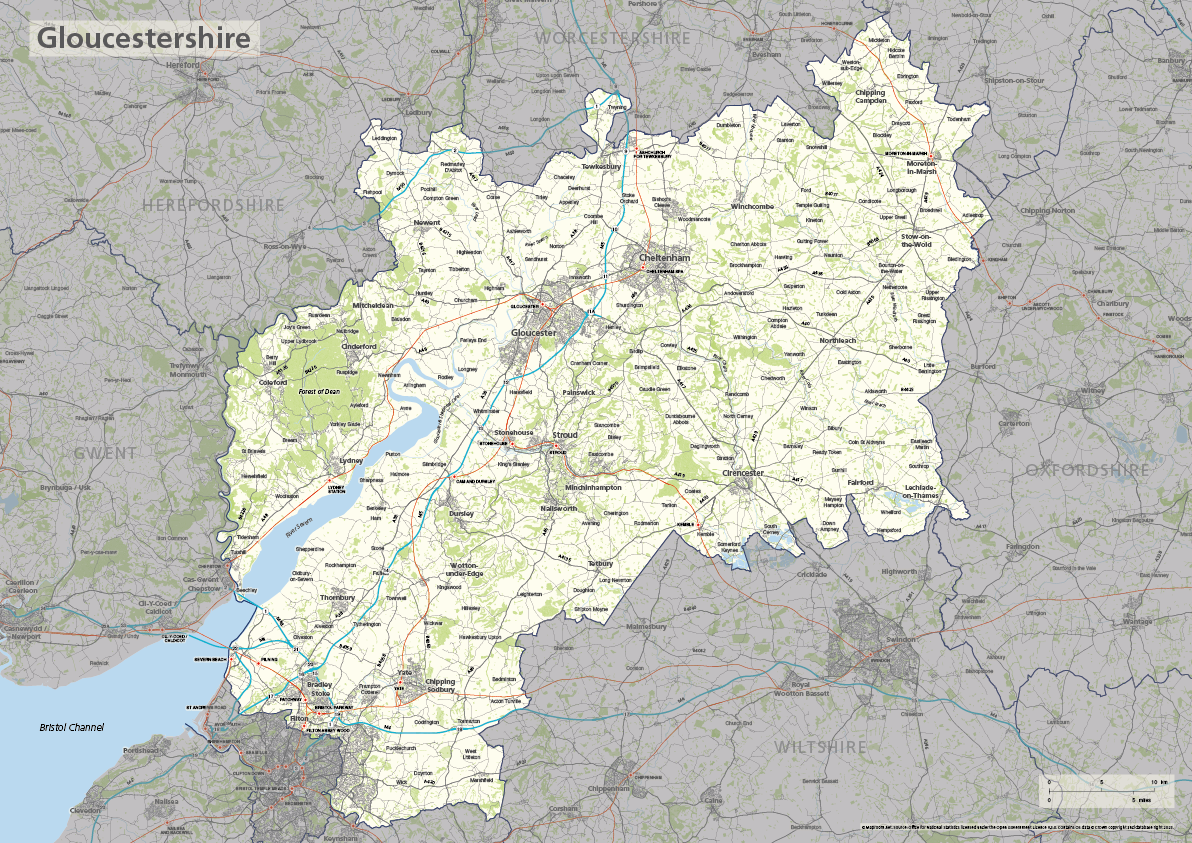
Gloucestershire county map
£40.00The ceremonial county of Gloucestershire is highlighted along with towns, villages, roads, railway lines, lakes, rivers, woodland and green spaces. Scaled for A3+ printing
PDFSVGLayered AI file -
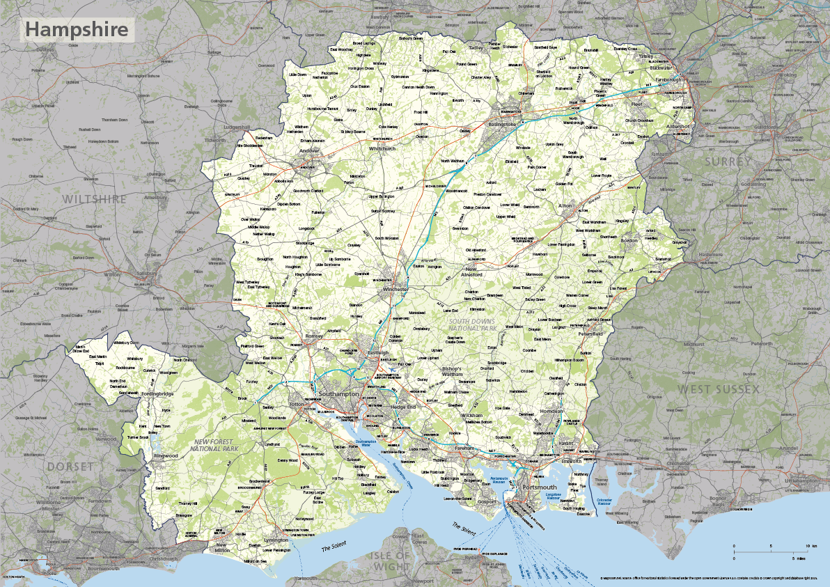
Hampshire county map
£40.00The ceremonial county of Hampshire is highlighted along with towns, villages, roads, railway lines, lakes, rivers, woodland and green spaces. Scaled for A3+ printing
PDFSVGLayered AI file -
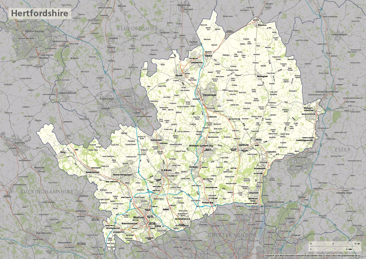
Hertfordshire county map
£40.00The ceremonial county of Hertfordshire is highlighted along with towns, villages, roads, railway lines, lakes, rivers, woodland and green spaces. Scaled for A3+ printing
PDFSVGLayered AI file -
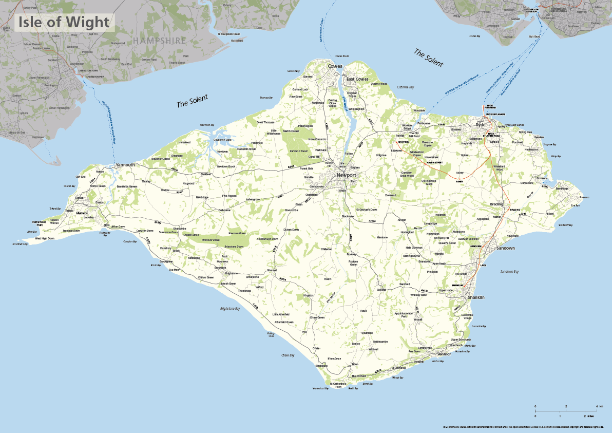
Isle of Wight map
£40.00The ceremonial county of the Isle of Wight is highlighted along with towns, villages, roads, railway lines, lakes, rivers, woodland and green spaces. Scaled for A3+ printing
PDFSVGLayered AI file -

Kent county map
£40.00The ceremonial county of Kent is highlighted along with towns, villages, roads, railway lines, lakes, rivers, woodland and green spaces. Scaled for A3+ printing
PDFSVGLayered AI file -
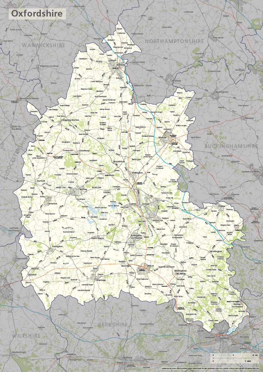
Oxfordshire county map
£40.00The ceremonial county of Oxfordshire is highlighted along with towns, villages, roads, railway lines, lakes, rivers, woodland and green spaces. Scaled for A3+ printing
PDFSVGLayered AI file -
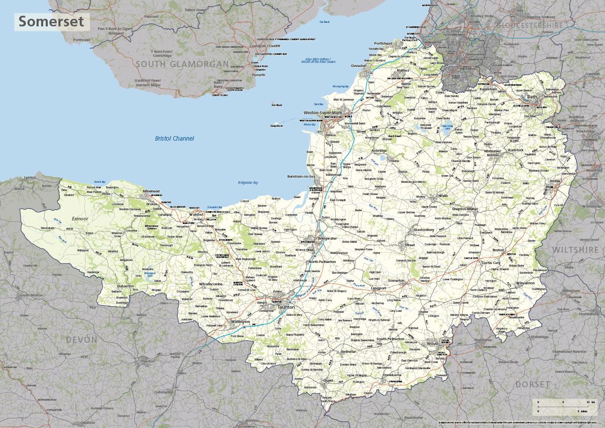
Somerset county map
£40.00The ceremonial county of Somerset is highlighted along with towns, villages, roads, railway lines, lakes, rivers, woodland and green spaces. Scaled for A3+ printing
PDFSVGLayered AI file -
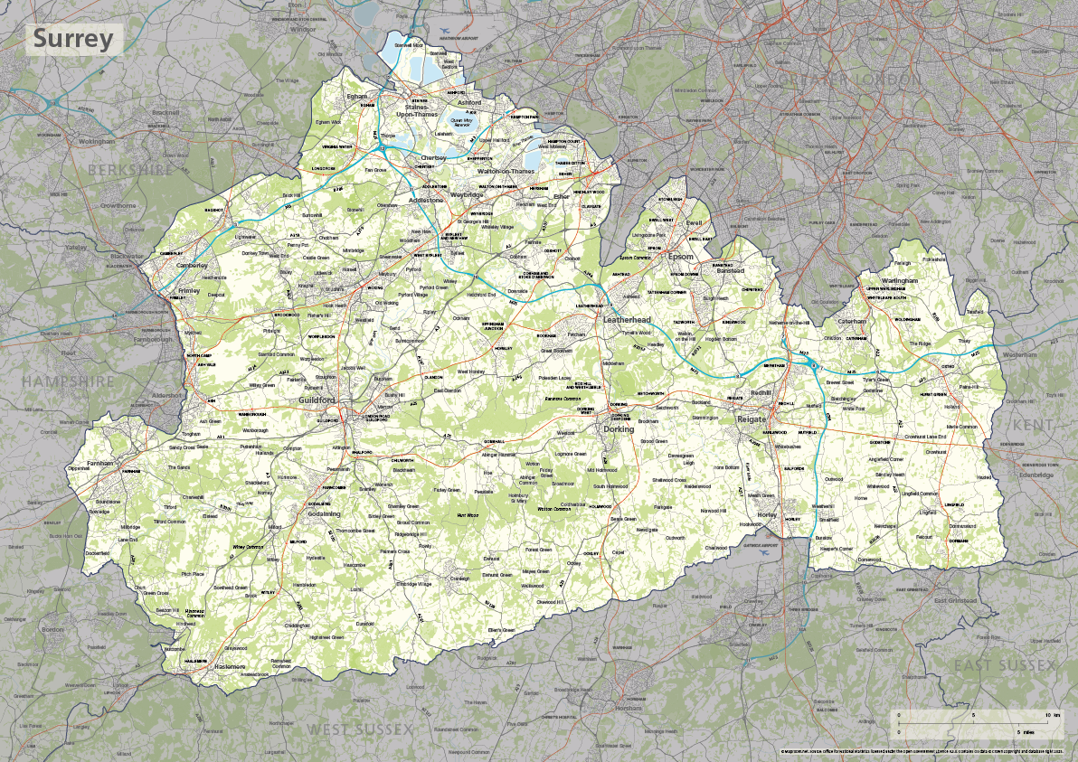
Surrey county map
£40.00The ceremonial county of Surrey is highlighted along with towns, villages, roads, railway lines, lakes, rivers, woodland and green spaces. Scaled for A3+ printing
PDFSVGLayered AI file -
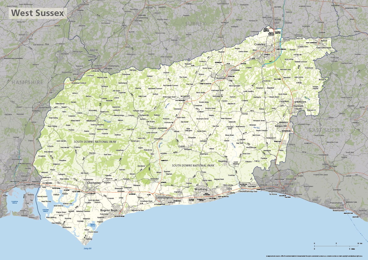
West Sussex county map
£40.00The ceremonial county of West Sussex is highlighted along with towns, villages, roads, railway lines, lakes, rivers, woodland and green spaces. Scaled for A3+ printing
PDFSVGLayered AI file -
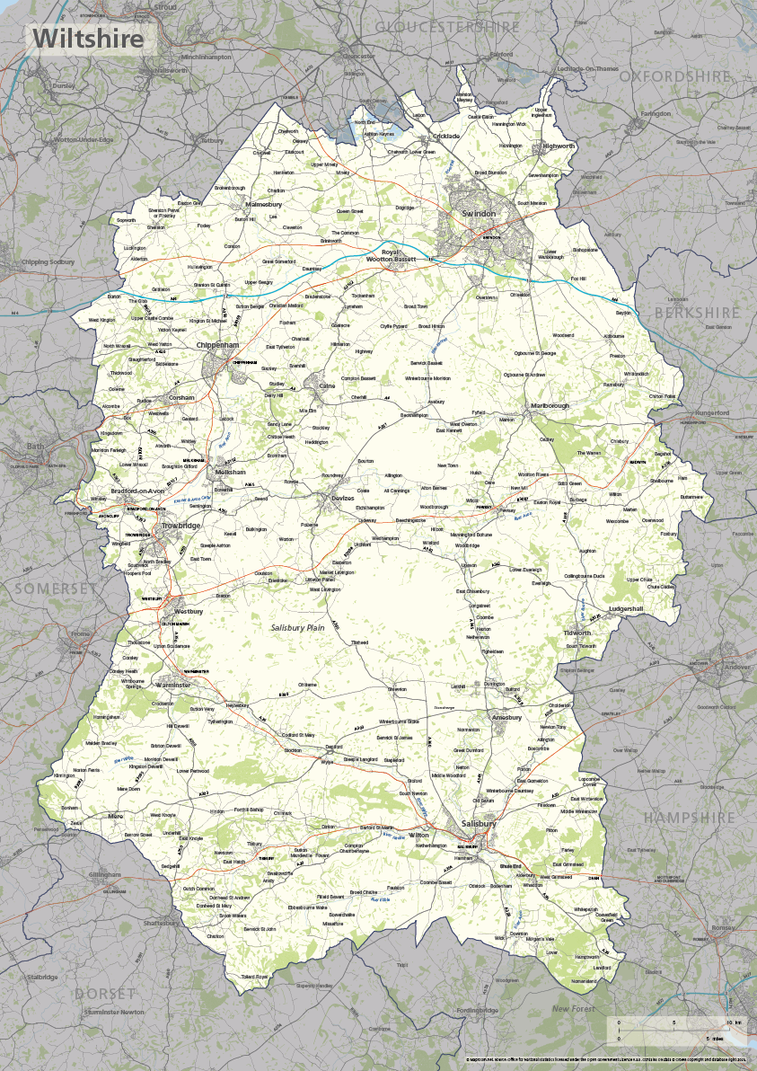
Wiltshire county map
£40.00The ceremonial county of Wiltshire is highlighted along with towns, villages, roads, railway lines, lakes, rivers, woodland and green spaces. Scaled for A3+ printing
PDFSVGLayered AI file -

Best maps of central London postcode districts – W1, WC, EC – including street names
£25.00See the road names and other street level details of London’s densely packed W1, WC and EC postcode districts overlaid with clear labels, district boundaries and underlying polygons for colour editing.
PDFSVGLayered AI file -
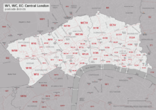
Map of central London postcode districts – W1, WC, EC
£20.00Central London postcode districts – W1, WC, EC – scaled for A4+ printing
PDF -

Map of AB postcode districts – Aberdeen
£15.00The AB – Aberdeen postcode districts scaled for A4+ printing
PDF -
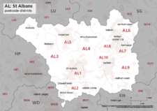
Map of AL postcode districts – St Albans
£15.00The AL – St Albans postcode districts scaled for A4+ printing
PDF -
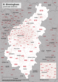
Map of B postcode districts – Birmingham
£15.00The B – Birmingham postcode districts scaled for A4+ printing
PDF -
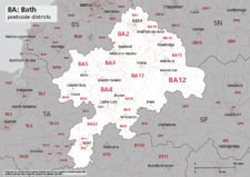
Map of BA postcode districts – Bath
£15.00The BA – Bath postcode districts scaled for A4+ printing
PDF -
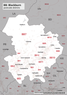
Map of BB postcode districts – Blackburn
£15.00The BB – Blackburn postcode districts scaled for A4+ printing
PDF -
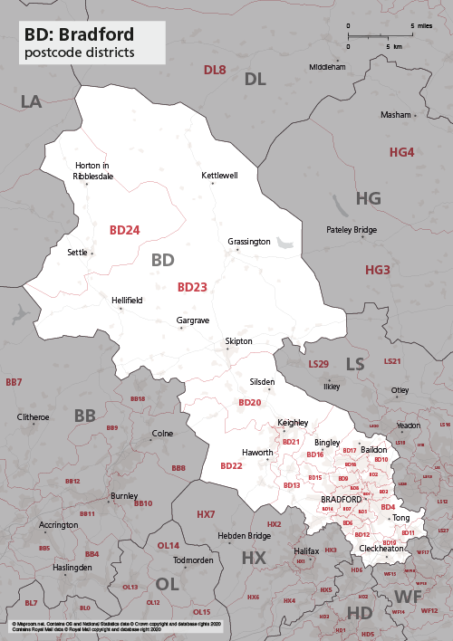
Map of BD postcode districts – Bradford
£15.00The BD – Bradford postcode districts scaled for A4+ printing
PDF -
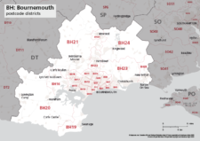
Map of BH postcode districts – Bournemouth
£15.00The BH – Bournemouth postcode districts scaled for A4+ printing
PDF -
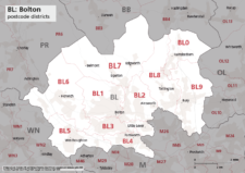
Map of BL postcode districts – Bolton
£15.00The BL – Bolton postcode districts scaled for A4+ printing
PDF -
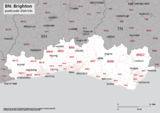
Map of BN postcode districts – Brighton
£15.00The BN – Brighton postcode districts scaled for A4+ printing
PDF -
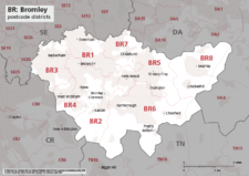
Map of BR postcode districts – Bromley
£15.00The BR – Bromley postcode districts scaled for A4+ printing
PDF -

Map of BS postcode districts – Bristol
£15.00The BS – Bristol postcode districts scaled for A4+ printing
PDF -
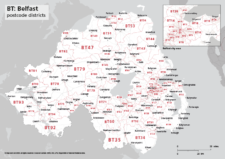
Map of BT postcode districts – Belfast
£15.00The BT – Belfast postcode districts scaled for A4+ printing
PDF -
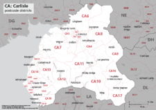
Map of CA postcode districts – Carlisle
£15.00The CA – Carlisle postcode districts scaled for A4+ printing
PDF -

Map of CB postcode districts – Cambridge
£15.00The CB – Cambridge postcode districts scaled for A4+ printing
PDF -
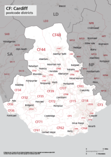
Map of CF postcode districts – Cardiff
£15.00The CF – Cardiff postcode districts scaled for A4+ printing
PDF -

Map of CH postcode districts – Chester
£15.00The CH – Chester postcode districts scaled for A4+ printing
PDF -
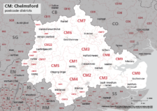
Map of CM postcode districts – Chelmsford
£15.00The CM – Chelmsford postcode districts scaled for A4+ printing
PDF -
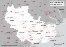
Map of CO postcode districts – Colchester
£15.00The CO – Colchester postcode districts scaled for A4+ printing
PDF -
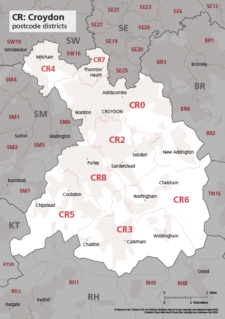
Map of CR postcode districts – Croydon
£15.00The CR – Croydon postcode districts scaled for A4+ printing
PDF -
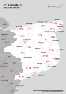
Map of CT postcode districts – Canterbury
£15.00The CT – Canterbury postcode districts scaled for A4+ printing
PDF -
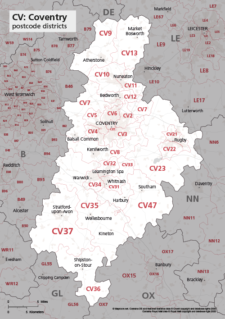
Map of CV postcode districts – Coventry
£15.00The CV – Coventry postcode districts scaled for A4+ printing
PDF -
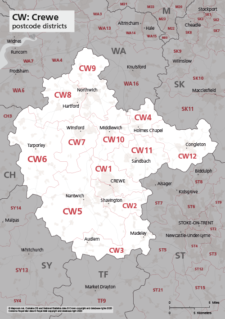
Map of CW postcode districts – Crewe
£15.00The CW – Crewe postcode districts scaled for A4+ printing
PDF -
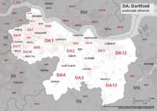
Map of DA postcode districts – Dartford
£15.00The DA – Dartford postcode districts scaled for A4+ printing
PDF -
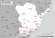
Map of DD postcode districts – Dundee
£15.00The DD – Dundee postcode districts scaled for A4+ printing
PDF -
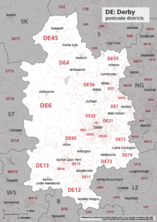
Map of DE postcode districts – Derby
£15.00The DE – Derby postcode districts scaled for A4+ printing
PDF -
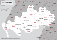
Map of DG postcode districts – Dumfries
£15.00The DG – Dumfries postcode districts scaled for A4+ printing
PDF -
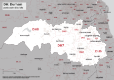
Map of DH postcode districts – Durham
£15.00The DH – Durham postcode districts scaled for A4+ printing
PDF -
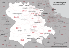
Map of DL postcode districts – Darlington
£15.00The DL – Darlington postcode districts scaled for A4+ printing
PDF -
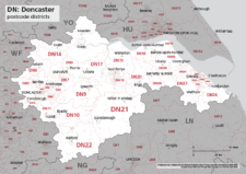
Map of DN postcode districts – Doncaster
£15.00The DN – Doncaster postcode districts scaled for A4+ printing
PDF -
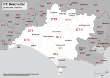
Map of DT postcode districts – Dorchester
£15.00The DT – Dorchester postcode districts scaled for A4+ printing
PDF -
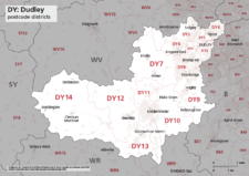
Map of DY postcode districts – Dudley
£15.00The DY – Dudley postcode districts scaled for A4+ printing
PDF -
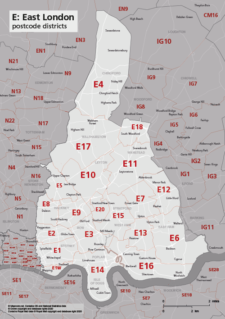
Map of E postcode districts – East London
£15.00The E – East London postcode districts scaled for A4+ printing
PDF -
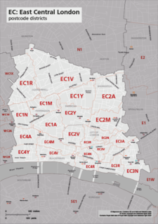
Map of EC postcode districts – East Central London
£15.00The EC – East Central London postcode districts scaled for A4+ printing
PDF -
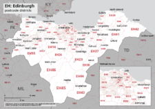
Map of EH postcode districts – Edinburgh
£15.00The EH – Edinburgh postcode districts scaled for A4+ printing
PDF -
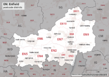
Map of EN postcode districts – Enfield
£15.00The EN – Enfield postcode districts scaled for A4+ printing
PDF -
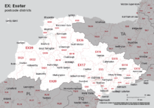
Map of EX postcode districts – Exeter
£15.00The EX – Exeter postcode districts scaled for A4+ printing
PDF -
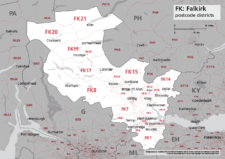
Map of FK postcode districts – Falkirk
£15.00The FK – Falkirk postcode districts scaled for A4+ printing
PDF -
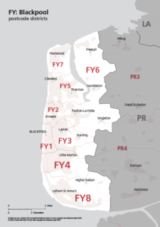
Map of FY postcode districts – Blackpool
£15.00The FY – Blackpool postcode districts scaled for A4+ printing
PDF -
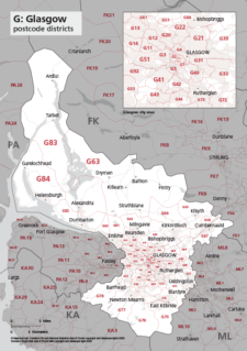
Map of G postcode districts – Glasgow
£15.00The G – Glasgow postcode districts scaled for A4+ printing
PDF -
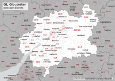
Map of GL postcode districts – Gloucester
£15.00The GL – Gloucester postcode districts scaled for A4+ printing
PDF -
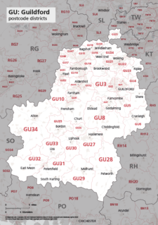
Map of GU postcode districts – Guildford
£15.00The GU – Guildford postcode districts scaled for A4+ printing
PDF -
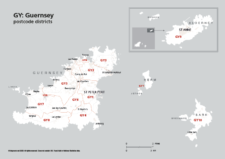
Map of GY postcode districts – Guernsey
£15.00The GY – Guernsey postcode districts scaled for A4+ printing
PDF -
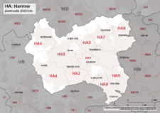
Map of HA postcode districts – Harrow
£15.00The HA – Harrow postcode districts scaled for A4+ printing
PDF -
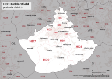
Map of HD postcode districts – Huddersfield
£15.00The HD – Huddersfield postcode districts scaled for A4+ printing
PDF -
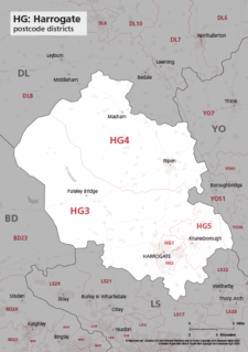
Map of HG postcode districts – Harrogate
£15.00The HG – Harrogate postcode districts scaled for A4+ printing
PDF -
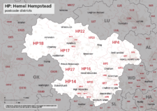
Map of HP postcode districts – Hemel Hempstead
£15.00The HP – Hemel Hempstead postcode districts scaled for A4+ printing
PDF -

Map of HR postcode districts – Hereford
£15.00The HR – Hereford postcode districts scaled for A4+ printing
PDF -
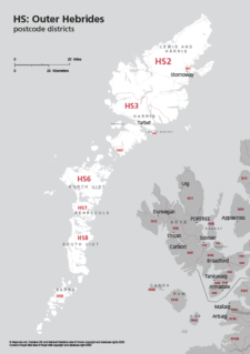
Map of HS postcode districts – Outer Hebrides
£15.00The HS – Outer Hebrides postcode districts scaled for A4+ printing
PDF -
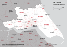
Map of HU postcode districts – Hull
£15.00The AB – Aberdeen postcode districts scaled for A4+ printing
PDF -
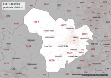
Map of HX postcode districts – Halifax
£15.00The HX – Halifax postcode districts scaled for A4+ printing
PDF -
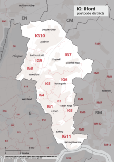
Map of IG postcode districts – Ilford
£15.00The IG – Ilford postcode districts scaled for A4+ printing
PDF -
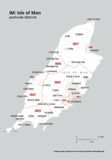
Map of IM postcode districts – Isle of Man
£15.00The IM – Isle of Man postcode districts scaled for A4+ printing
PDF -
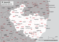
Map of IP postcode districts – Ipswich
£15.00The IP – Ipswich postcode districts scaled for A4+ printing
PDF -
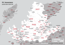
Map of IV postcode districts – Inverness
£15.00The IV – Inverness postcode districts scaled for A4+ printing
PDF -
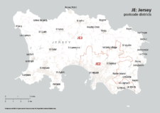
Map of JE postcode districts – Jersey
£15.00The JE – Jersey postcode districts scaled for A4+ printing
PDF -
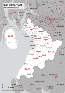
Map of KA postcode districts – Kilmarnock
£15.00The KA – Kilmarnock postcode districts scaled for A4+ printing
PDF -
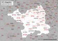
Map of KT postcode districts – Kingston-upon-Thames
£15.00The KT – Kingston upon Thames postcode districts scaled for A4+ printing
PDF -
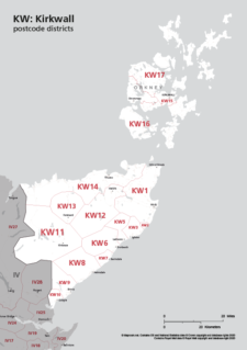
Map of KW postcode areas – Kirkwall
£15.00The KW – Kirkwall postcode districts scaled for A4+ printing
PDF -
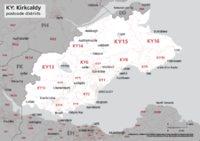
Map of KY postcode districts – Kirkcaldy
£15.00The KY – Kirkcaldy postcode districts scaled for A4+ printing
PDF -
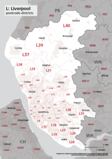
Map of L postcode districts – Liverpool
£15.00The L – Liverpool postcode districts scaled for A4+ printing
PDF -
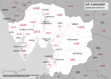
Map of LA postcode districts – Lancaster
£15.00The LA – Lancaster postcode districts scaled for A4+ printing
PDF -
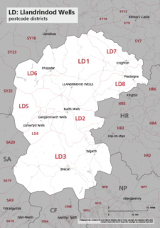
Map of LD postcode districts – Llandrindod Wells
£15.00The LD – Llandrindrod Wells postcode districts scaled for A4+ printing
PDF -
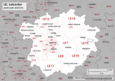
Map of LE postcode districts – Leicester
£15.00The LE – Leicester postcode districts scaled for A4+ printing
PDF -
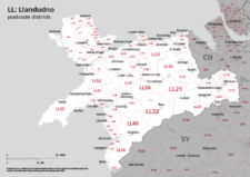
Map of LL postcode districts – Llandudno
£15.00The LL – Llandudno postcode districts scaled for A4+ printing
PDF -
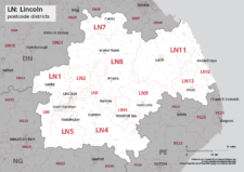
Map of LN postcode districts – Lincoln
£15.00The LN – Lincoln postcode districts scaled for A4+ printing
PDF -
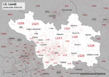
Map of LS postcode districts – Leeds
£15.00The LS – Leeds postcode districts scaled for A4+ printing
PDF -
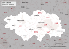
Map of LU postcode districts – Luton
£15.00The LU – Luton postcode districts scaled for A4+ printing
PDF -
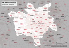
Map of M postcode districts – Manchester
£15.00The M – Manchester postcode districts scaled for A4+ printing
PDF -
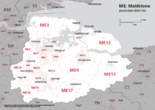
Map of ME postcode districts – Rochester / Medway
£15.00The ME – Maidstone postcode districts scaled for A4+ printing
PDF -
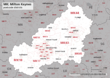
Map of MK postcode districts – Milton Keynes
£15.00The MK – Milton Keynes postcode districts scaled for A4+ printing
PDF -
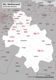
Map of ML postcode districts – Motherwell
£15.00The ML – Motherwell postcode districts scaled for A4+ printing
PDF -
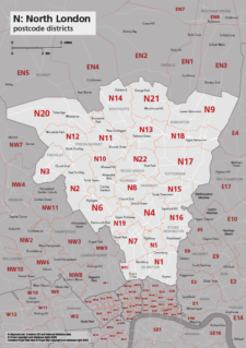
Map of N postcode districts – North London
£15.00The N – North London postcode districts scaled for A4+ printing
PDF -
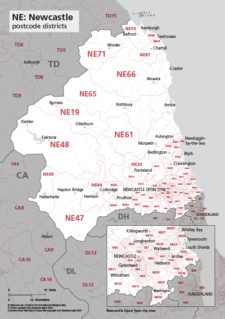
Map of NE postcode districts – Newcastle-upon-Tyne
£15.00The AB – Aberdeen postcode districts scaled for A4+ printing
PDF -
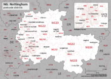
Map of NG postcode districts – Nottingham
£15.00The NG – Nottingham postcode districts scaled for A4+ printing
PDF -

Map of NN postcode districts – Northampton
£15.00The NN – Northampton postcode districts scaled for A4+ printing
PDF -
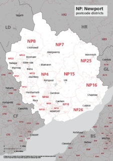
Map of NP postcode districts – Newport
£15.00The NP – Newport postcode districts scaled for A4+ printing
PDF -
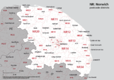
Map of NR postcode districts – Norwich
£15.00The NR – Norwich postcode districts scaled for A4+ printing
PDF -
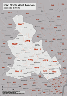
Map of NW postcode districts – North West London
£15.00The NW – North West London postcode districts scaled for A4+ printing
PDF -
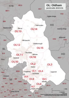
Map of OL postcode districts – Oldham
£15.00The OL – Oldham postcode districts scaled for A4+ printing
PDF -
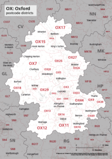
Map of OX postcode districts – Oxford
£15.00The OX – Oxford postcode districts scaled for A4+ printing
PDF -
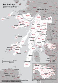
Map of PA postcode districts – Paisley
£15.00The PA – Paisley postcode districts scaled for A4+ printing
PDF -

Map of PE postcode districts – Peterborough
£15.00The PE – Peterborough postcode districts scaled for A4+ printing
PDF -
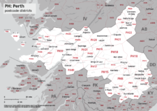
Map of PH postcode districts – Perth
£15.00The PH – Perth postcode districts scaled for A4+ printing
PDF -

Map of PL postcode districts – Plymouth
£15.00The PL – Plymouth postcode districts scaled for A4+ printing
PDF -
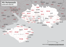
Map of PO postcode districts – Portsmouth
£15.00The PO – Portsmouth postcode districts scaled for A4+ printing
PDF -
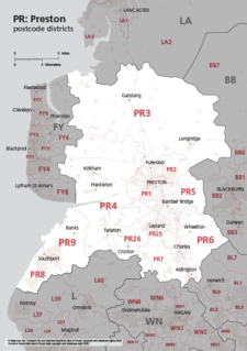
Map of PR postcode districts – Preston
£15.00The PR – Preston postcode districts scaled for A4+ printing
PDF -
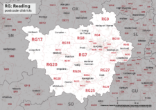
Map of RG postcode districts – Reading
£15.00The RG – Reading postcode districts scaled for A4+ printing
PDF -
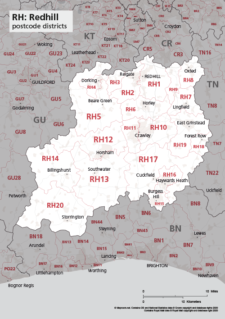
Map of RH postcode districts – Redhill
£15.00The RH – Redhill postcode districts scaled for A4+ printing
PDF -
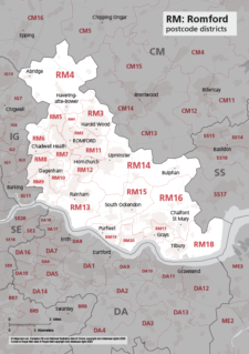
Map of RM postcode districts – Romford
£15.00The RM – Romford postcode districts scaled for A4+ printing
PDF -
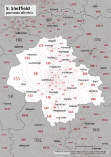
Map of S postcode districts – Sheffield
£15.00The S – Sheffield postcode districts scaled for A4+ printing
PDF -
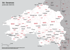
Map of SA postcode districts – Swansea
£15.00The SA – Swansea postcode districts scaled for A4+ printing
PDF -
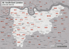
Map of SE postcode districts – South East London
£15.00The SE – South East London postcode districts scaled for A4+ printing
PDF -
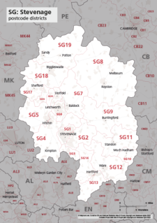
Map of SG postcode districts – Stevenage
£15.00The SG – Stevenage postcode districts scaled for A4+ printing
PDF -

Map of SK postcode districts – Stockport
£15.00The SK – Stockport postcode districts scaled for A4+ printing
PDF -
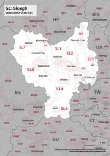
Map of SL postcode districts – Slough
£15.00The SL – Slough postcode districts scaled for A4+ printing
PDF