Maproom

Editable & interactive digital maps

  • about
  • news & blog
  • contact
  • 0 items
Log in
    • Home
  • Britain & Ireland maps
    • Britain and Ireland
    • UK - United Kingdom
    • Ireland
    • England
    • Scotland
    • Wales
    • Northern Ireland
    • Isle of Man
    • Channel Islands
  • City maps
    • Birmingham
    • Brighton
    • Bristol
    • Cardiff
    • Edinburgh
    • Exeter
    • Glasgow
    • Liverpool
    • London
    • Manchester
    • Oxford
  • Postcode maps
    • Overview
    • Dynamic postcode mapping tools
    • Downloadable postcode maps
  • Admin / region maps
    • UK administrative regions
    • County maps
    • Local authority maps
    • London borough maps
    • Transport maps
    • National park maps
  • World maps
    • World maps
    • Europe maps
    • Map of EU countries 2026
    • Maps of France
    • Maps of Germany
    • Maps of New York and environs
  • DYNAMIC MAPPING
    • Showcase
    • Dynamic Mapping Suite info
    • PASS PRICING
  • BESPOKE

Postcodes Mapping

  • Overview

Dynamic postcodes

  • Dynamic postcode mapping tools

Downloadable postcode maps

  • UK postcodes
  • London postcodes
  • Postcodes scaled for easy A4 printing
    • FULL SET with 126 maps
    • Central London – W1, WC, EC
    • AB – Aberdeen
    • AL – St Albans
    • B – Birmingham
    • BA – Bath
    • BB – Blackburn
    • BD – Bradford
    • BH – Bournemouth
    • BL – Bolton
    • BN – Brighton
    • BR – Bromley
    • BS – Bristol
    • BT – Belfast
    • CA – Carlisle
    • CB – Cambridge
    • CF – Cardiff
    • CH – Chester
    • CM – Chelmsford
    • CO – Colchester
    • CR – Croydon
    • CT – Canterbury
    • CV – Coventry
    • CW – Crewe
    • DA – Dartford
    • DD – Dundee
    • DE – Derby
    • DG – Dumfries
    • DH – Durham
    • DL – Darlington
    • DN – Doncaster
    • DT – Dorchester
    • DY – Dudley
    • E – East London
    • EC – East Central London
    • EH – Edinburgh
    • EN – Enfield
    • EX – Exeter
    • FK – Falkirk
    • FY – Blackpool
    • G – Glasgow
    • GL – Gloucester
    • GU – Guildford
    • GY – Guernsey
    • HA – Harrow
    • HD – Huddersfield
    • HG – Harrogate
    • HP – Hemel Hempstead
    • HR – Hereford
    • HS – Outer Hebrides
    • HU – Hull
    • HX – Halifax
    • IG – Ilford
    • IM – Isle of Man
    • IP – Ipswich
    • IV – Inverness
    • JE – Jersey
    • KA – Kilmarnock
    • KT – Kingston-upon-Thames
    • KW – Kirkwall
    • KY – Kirkcaldy
    • L – Liverpool
    • LA – Lancaster
    • LD – Llandrindod Wells
    • LE – Leicester
    • LL – Llandudno
    • LN – Lincoln
    • LS – Leeds
    • LU – Luton
    • M – Manchester
    • ME – Rochester / Medway
    • MK – Milton Keynes
    • ML – Motherwell
    • N – North London
    • NE – Newcastle-upon-Tyne
    • NG – Nottingham
    • NN – Northampton
    • NP – Newport
    • NR – Norwich
    • NW – North West London
    • OL – Oldham
    • OX – Oxford
    • PA – Paisley
    • PE – Peterborough
    • PH – Perth
    • PL – Plymouth
    • PO – Portsmouth
    • PR – Preston
    • RG – Reading
    • RH – Redhill
    • RM – Romford
    • S – Sheffield
    • SA – Swansea
    • SE – South East London
    • SG – Stevenage
    • SK – Stockport
    • SL – Slough
    • SM – Sutton
    • SN – Swindon
    • SO – Southampton
    • SP – Salisbury
    • SR – Sunderland
    • SS – Southend-on-Sea
    • ST – Stoke-on-Trent
    • SW – South West London
    • SY – Shrewsbury
    • TA – Taunton
    • TD – Galashiels / Tweeddale
    • TF – Telford
    • TN – Tonbridge
    • TQ – Torquay
    • TR – Truro
    • TS – Cleveland / Teesside
    • TW – Twickenham
    • UB – Uxbridge / Southall
    • W – West London
    • WA – Warrington
    • WC – West Central London
    • WD – Watford
    • WF – Wakefield
    • WN – Wigan
    • WR – Worcester
    • WS – Walsall
    • WV – Wolverhampton
    • YO – York
    • ZE – Lerwick

London postcode maps

These maps are available as downloadable PDFs which can be edited by graphic designers. They are also offered as bundles with our dynamic online postcode maps.

Purchasing multiple postcode maps? Use coupon code multibuy-postcodes at checkout to get 50% discount on two or more downloadable postcode maps.

Showing all 12 results

  • supersize Greater London postcodes preview

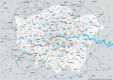
    Supersize map of Greater London postcode districts with full road network

    £75.00

    Editable postcodes artwork scaled at 4.3 x 3.8 metres in its opening state. The full road network of Greater London is the backdrop, with major road names legible at large-scale printing.

    PDFsLayered AI file
  • Greater London ULEZ map - LEZ Low Emission - DVS - Congestion Charge - postcode boundaries - interactive map preview

    Interactive map of London Low and Ultra-low Emission Zones (LEZ / ULEZ), Congestion Charge Zone (CCZ), with all postcodes

    £35.00

    London’s Low Emission Zone and Driver Vision Standard (LEZ / DVS), Ultra-low Emission Zone (ULEZ),  and Congestion Charge Zone (CCZ) juxtaposed with postcodes and local authority / London borough boundaries – this interactive online map is aimed primarily at businesses needing help to plan deliveries, driving routes and sales territories through and around London.

  • Greater London postcodes map preview

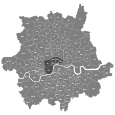
    Map of Greater London postcode districts plus boroughs and major roads

    £35.00

    All the postcode districts in Greater London, shown in context with the London boroughs, post towns, major roads and surrounding counties. Scaled for A3 and above.

    PDFsSVGLayered AI file
  • London W WC EC postcode districts detailed map preview v1

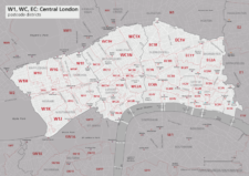
    Best maps of central London postcode districts – W1, WC, EC – including street names

    £40.00

    See the road names and other street level details of London’s densely packed W1, WC and EC postcode districts overlaid with clear labels, district boundaries and underlying polygons for colour editing.

    PDFSVGLayered AI file
  • London postcodes map

    Map of London postcodes – interlocking shapes

    £35.00

    All the London postcode areas including the central sub-districts are included with accurate, interlocking vector shapes.

    PDFsSVGLayered AI file
  • Central London postcodes map preview

    Map of central London postcode districts – W1, WC, EC

    £25.00

    Central London postcode districts – W1, WC, EC – scaled for A4+ printing

    PDF
  • E postcode districts map preview

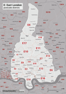
    Map of E postcode districts – East London

    £25.00

    The E – East London postcode districts scaled for A4+ printing

    PDF
  • EC postcode districts map preview

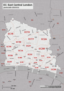
    Map of EC postcode districts – East Central London

    £25.00

    The EC – East Central London postcode districts scaled for A4+ printing

    PDF
  • SE postcode districts map preview

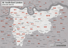
    Map of SE postcode districts – South East London

    £25.00

    The SE – South East London postcode districts scaled for A4+ printing

    PDF
  • SW postcode districts map preview

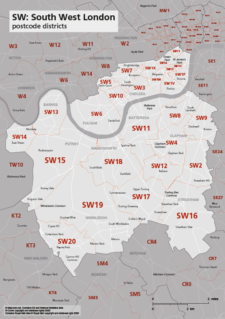
    Map of SW postcode districts – South West London

    £25.00

    The SW – South West London postcode districts scaled for A4+ printing

    PDF
  • W postcode districts map preview

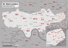
    Map of W postcode districts – West London

    £25.00

    The W – West London postcode districts scaled for A4+ printing

    PDF
  • WC postcode districts map preview

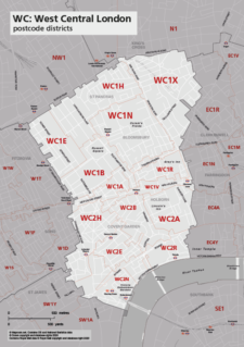
    Map of WC postcode districts – West Central London

    £25.00

    The WC – West Central London postcode districts scaled for A4+ printing

    PDF
  • Standard royalty free terms for downloadable maps
  • Licensing terms for downloadable postcode maps
  • Licensing terms for dynamic online maps
  • How to edit the downloadable maps
  • Refund, tax and pricing policies
  • Privacy & cookies

All content © Maproom at Blue Island Media · Award winning media projects