Administrative maps
Showing 1–150 of 179 results
-

Interactive map of London Low and Ultra-low Emission Zones (LEZ / ULEZ), Congestion Charge Zone (CCZ), with all postcodes
£45.00London’s Low Emission Zone and Driver Vision Standard (LEZ / DVS), Ultra-low Emission Zone (ULEZ), and Congestion Charge Zone (CCZ) juxtaposed with postcodes and local authority / London borough boundaries – this interactive online map is aimed primarily at businesses needing help to plan deliveries, driving routes and sales territories through and around London.
-
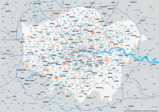
Map of Greater London postcode districts plus boroughs and major roads
£15.00All the postcode districts in Greater London, shown in context with the London boroughs, post towns, major roads and surrounding counties. Scaled for A3 and above.
PDFsSVGLayered AI file -

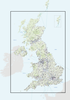
UK Local Authorities + Postcodes Map from April 2023
£60.00UK Local Authorities juxtaposed with postcodes districts, plus a Limited Free Pass for the Dynamic Mapping Suite giving access to online Local Authority maps and mapping tools.
PDFSVGLayered AI file -
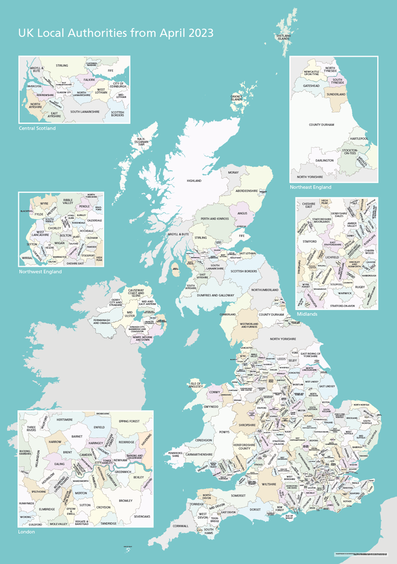
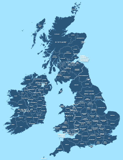
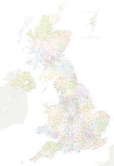
UK Local Authorities Map from April 2023
£40.00Shows all of the UK’s Local Authorities updated from April 2023. Sold in a package with simple poster versions and detailed context with towns and major roads. High-resolution PDFs, AI and SVG formats. All artwork layers can be edited. Also bundled with online Local Authority maps for super detail and dynamic mapping from spreadsheet.
PDFsSVGLayered AI file -

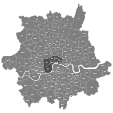
Map of London boroughs
£25.00All the London boroughs with options for showing the Thames.
PDFsSVGLayered AI file -
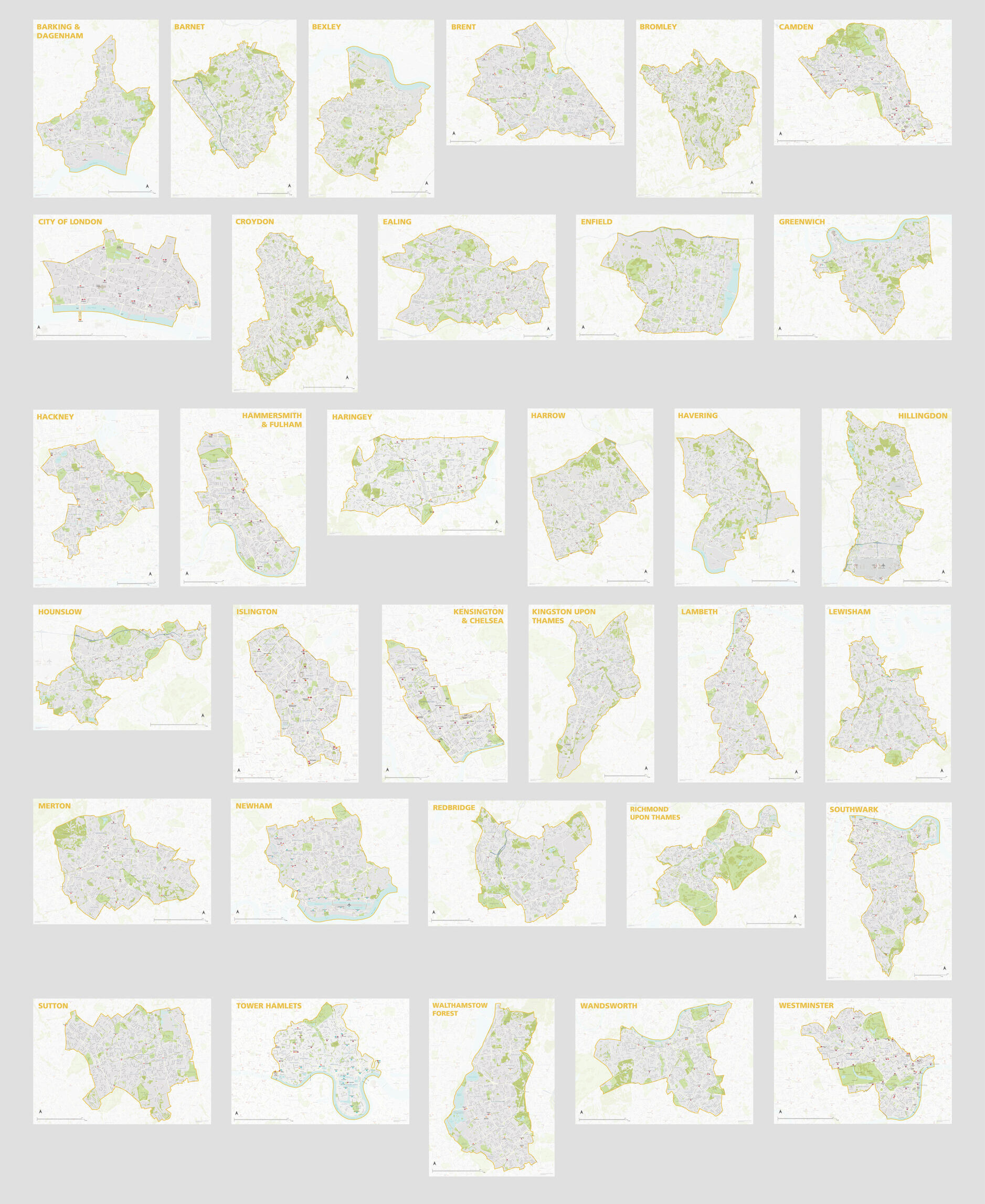
London Borough Maps: FULL SET of 34 maps
£300.00PDFsSVGLayered AI file -
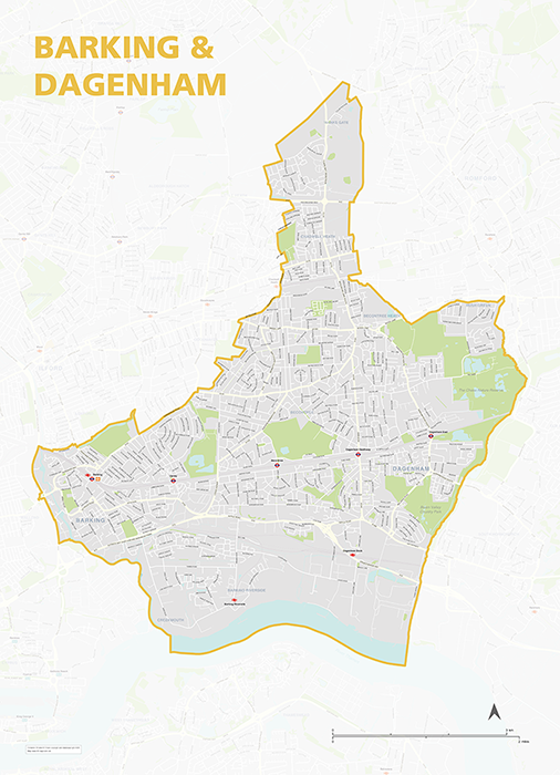
Barking & Dagenham – London borough map
£40.00Map of the London Borough of Barking and Dagenham, detailing the road and public transport network, as well as parks and other open areas. Designed for A1+ printing or editing for other uses.
PDFSVGLayered AI file -
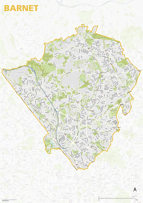
Barnet – London borough map
£40.00Map of the London Borough of Barnet, detailing the road and public transport network, as well as parks and other open areas. Designed for A1+ printing or editing for other uses.
PDFSVGLayered AI file -
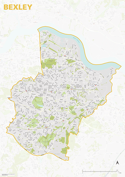
Bexley – London borough map
£40.00Map of the London Borough of Bexley, detailing the road and public transport network, as well as parks and other open areas. Designed for A1+ printing or editing for other uses.
PDFSVGLayered AI file -
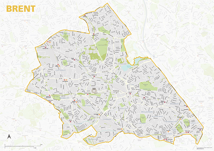
Brent – London borough map
£40.00Map of the London Borough of Brent, detailing the road and public transport network, as well as parks and other open areas. Designed for A1+ printing or editing for other uses.
PDFSVGLayered AI file -
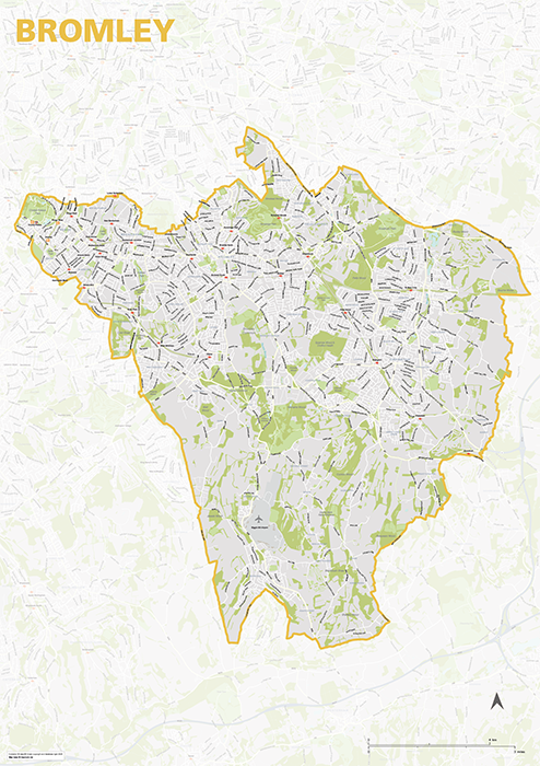
Bromley – London borough map
£40.00Map of the London Borough of Brent, detailing the road and public transport network, as well as parks and other open areas. Designed for A1+ printing or editing for other uses.
PDFSVGLayered AI file -

Camden – London borough map
£40.00Map of the London Borough of Camden, detailing the road and public transport network, as well as parks and other open areas. Designed for A1+ printing or editing for other uses.
PDFSVGLayered AI file -
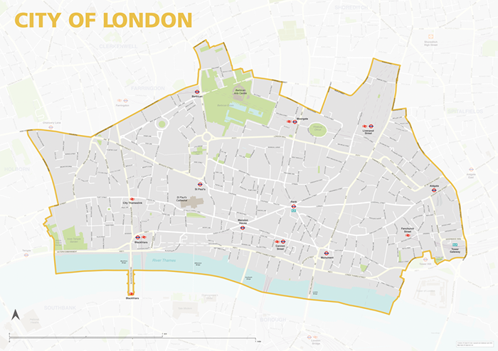
City of London – borough style map
£40.00Map of the City of London, detailing the road and public transport network, as well as park squares and other open areas. Designed for A1+ printing or editing for other uses.
PDFSVGLayered AI file -
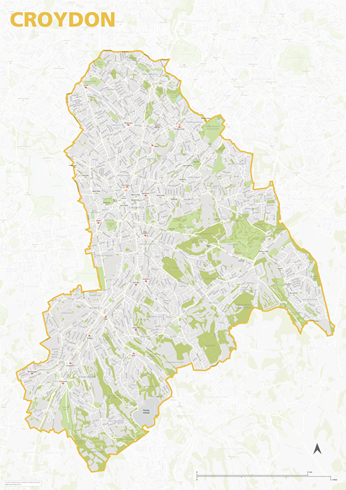
Croydon – London borough map
£40.00Map of the London Borough of Croydon, detailing the road and public transport network, as well as parks and other open areas. Designed for A1+ printing or editing for other uses.
PDFSVGLayered AI file -
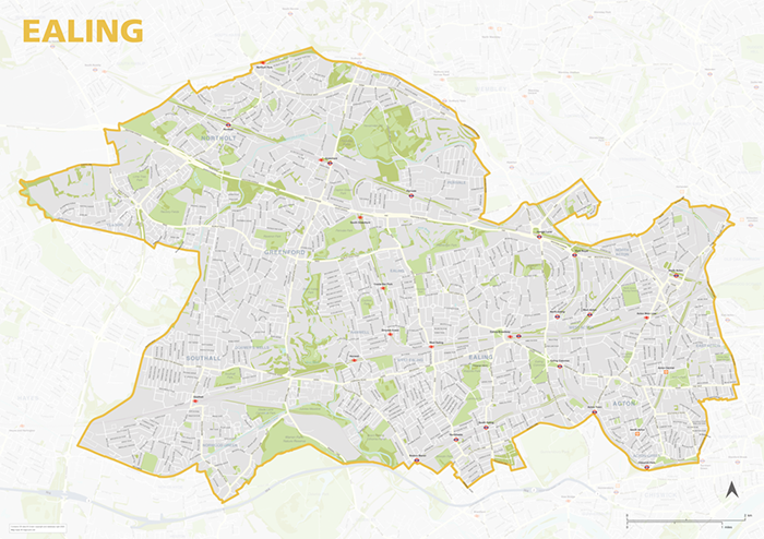
Ealing – London borough map
£40.00Map of the London Borough of Ealing, detailing the road and public transport network, as well as parks and other open areas. Designed for A1+ printing or editing for other uses.
PDFSVGLayered AI file -
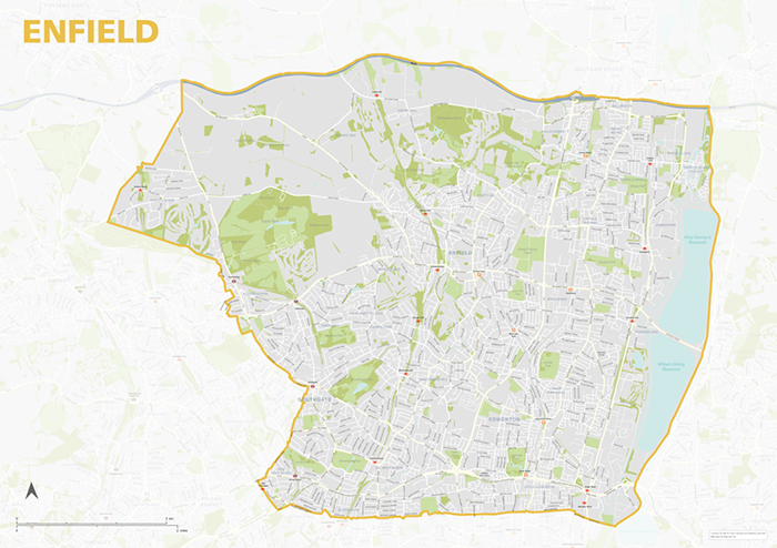
Enfield – London borough map
£40.00Map of the London Borough of Enfield, detailing the road and public transport network, as well as parks and other open areas. Designed for A1+ printing or editing for other uses.
PDFSVGLayered AI file -
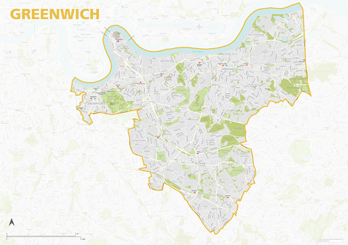
Greenwich – London borough map
£40.00Map of the London Borough of Greenwich, detailing the road and public transport network, as well as parks and other open areas. Designed for A1+ printing or editing for other uses.
PDFSVGLayered AI file -
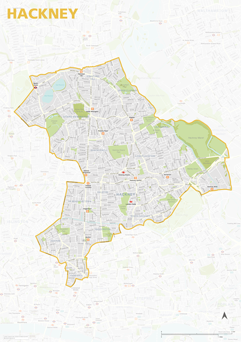
Hackney – London borough map
£40.00Map of the London Borough of Hackney, detailing the road and public transport network, as well as parks and other open areas. Designed for A1+ printing or editing for other uses.
PDFSVGLayered AI file -
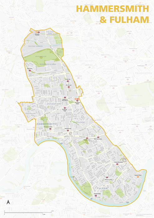
Hammersmith & Fulham – London borough map
£40.00Map of the London Borough of Hammersmith & Fulham, detailing the road and public transport network, as well as parks and other open areas. Designed for A1+ printing or editing for other uses.
PDFSVGLayered AI file -
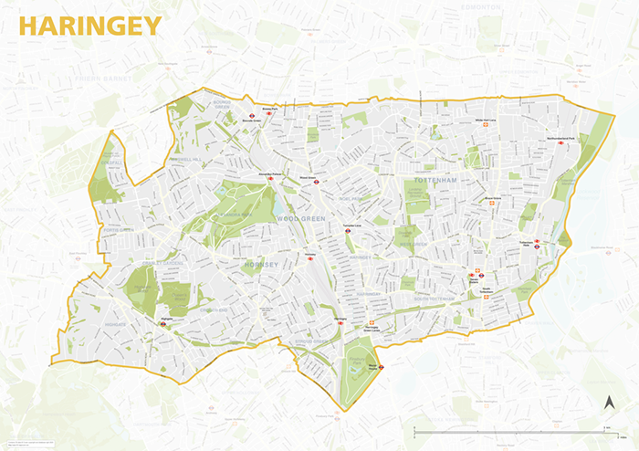
Haringey – London borough map
£40.00Map of the London Borough of Haringey, detailing the road and public transport network, as well as parks and other open areas. Designed for A1+ printing or editing for other uses.
PDFSVGLayered AI file -
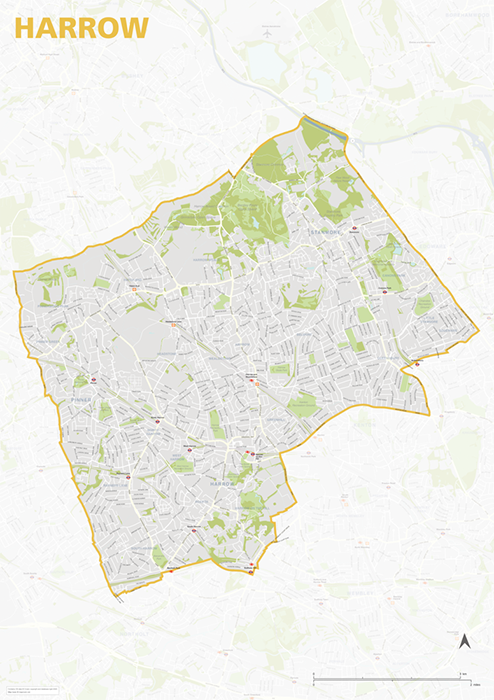
Harrow – London borough map
£40.00Map of the London Borough of Harrow, detailing the road and public transport network, as well as parks and other open areas. Designed for A1+ printing or editing for other uses.
PDFSVGLayered AI file -
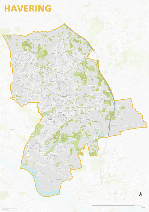
Havering – London borough map
£40.00Map of the London Borough of Havering, detailing the road and public transport network, as well as parks and other open areas. Designed for A1+ printing or editing for other uses.
PDFSVGLayered AI file -
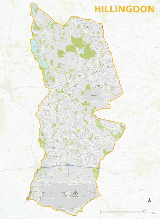
Hillingdon – London borough map
£40.00Map of the London Borough of Hillingdon, detailing the road and public transport network, as well as parks and other open areas. Designed for A1+ printing or editing for other uses.
PDFSVGLayered AI file -
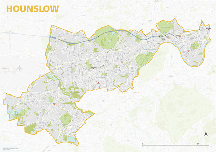
Hounslow – London borough map
£40.00Map of the London Borough of Hounslow, detailing the road and public transport network, as well as parks and other open areas. Designed for A1+ printing or editing for other uses.
PDFSVGLayered AI file -
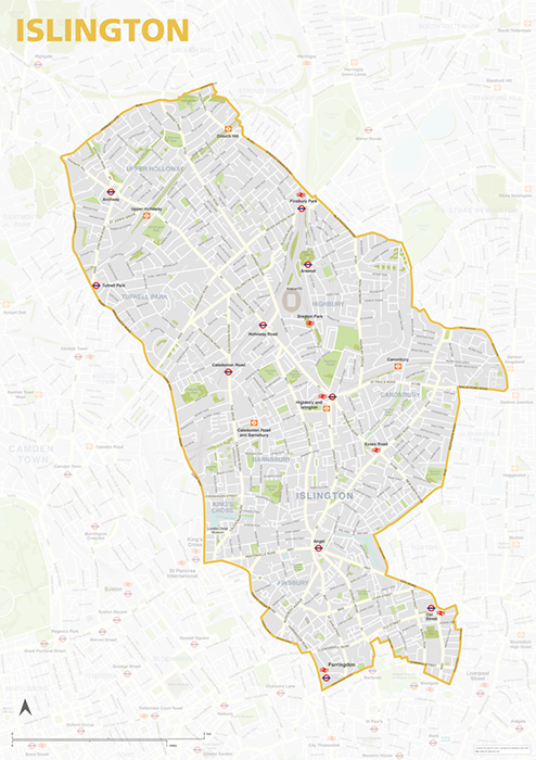
Islington – London borough map
£40.00Map of the London Borough of Islington, detailing the road and public transport network, as well as parks and other open areas. Designed for A1+ printing or editing for other uses.
PDFSVGLayered AI file -
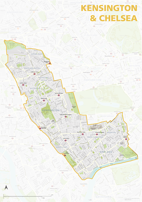
Kensington & Chelsea – London borough map
£40.00Map of the London Borough of Kensington & Chelsea, detailing the road and public transport network, as well as parks and other open areas. Designed for A1+ printing or editing for other uses.
PDFSVGLayered AI file -
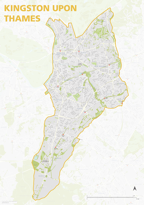
Kingston upon Thames – London borough map
£40.00Map of the London Borough of Kingston upon Thames, detailing the road and public transport network, as well as parks and other open areas. Designed for A1+ printing or editing for other uses.
PDFSVGLayered AI file -
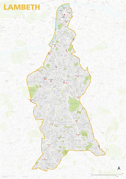
Lambeth – London borough map
£40.00Map of the London Borough of Lambeth, detailing the road and public transport network, as well as parks and other open areas. Designed for A1+ printing or editing for other uses.
PDFSVGLayered AI file -
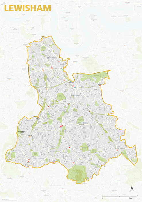
Lewisham – London borough map
£40.00Map of the London Borough of Lewisham, detailing the road and public transport network, as well as parks and other open areas. Designed for A1+ printing or editing for other uses.
PDFSVGLayered AI file -
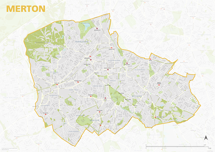
Merton – London borough map
£40.00Map of the London Borough of Merton, detailing the road and public transport network, as well as parks and other open areas. Designed for A1+ printing or editing for other uses.
PDFSVGLayered AI file -
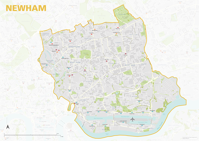
Newham – London borough map
£40.00Map of the London Borough of Newham, detailing the road and public transport network, as well as parks and other open areas. Designed for A1+ printing or editing for other uses.
PDFSVGLayered AI file -
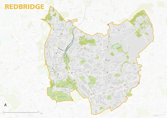
Redbridge – London borough map
£40.00Map of the London Borough of Redbridge, detailing the road and public transport network, as well as parks and other open areas. Designed for A1+ printing or editing for other uses.
PDFSVGLayered AI file -
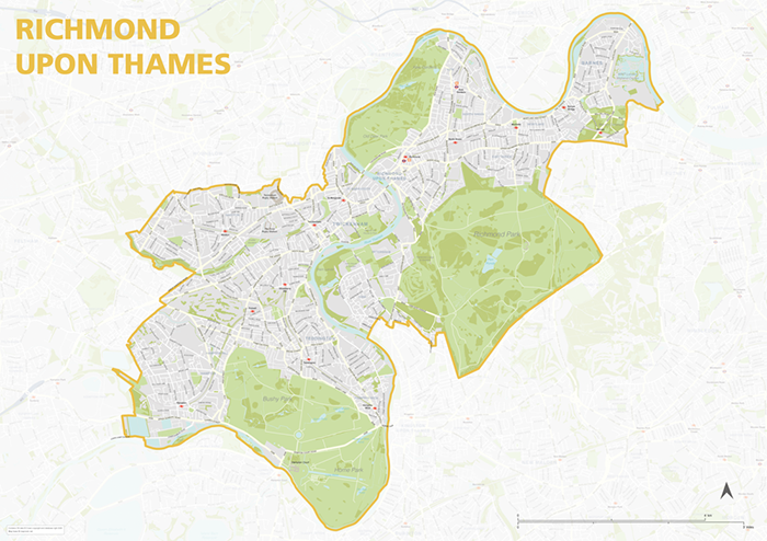
Richmond upon Thames – London borough map
£40.00Map of the London Borough of Richmond upon Thames, detailing the road and public transport network, as well as parks and other open areas. Designed for A1+ printing or editing for other uses.
PDFSVGLayered AI file -
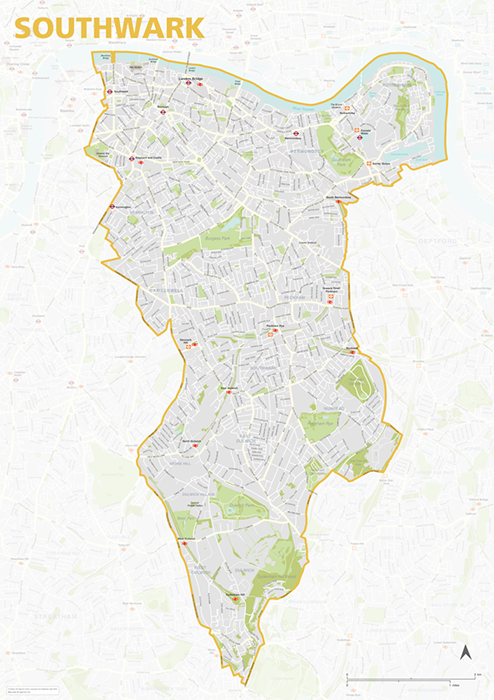
Southwark – London borough map
£40.00Map of the London Borough of Southwark, detailing the road and public transport network, as well as parks and other open areas. Designed for A1+ printing or editing for other uses.
PDFSVGLayered AI file -
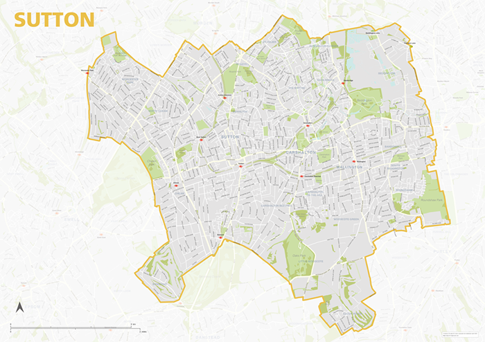
Sutton – London borough map
£40.00Map of the London Borough of Sutton, detailing the road and public transport network, as well as parks and other open areas. Designed for A1+ printing or editing for other uses.
PDFSVGLayered AI file -
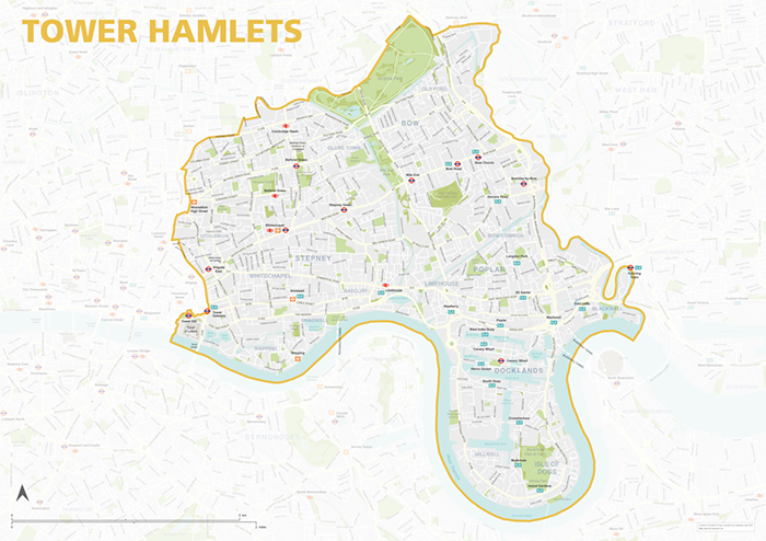
Tower Hamlets – London borough map
£40.00Map of the London Borough of Tower Hamlets, detailing the road and public transport network, as well as parks and other open areas. Designed for A1+ printing or editing for other uses.
PDFSVGLayered AI file -
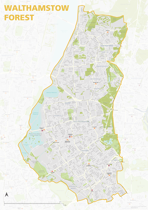
Waltham Forest – London borough map
£40.00Map of the London Borough of Tower Hamlets, detailing the road and public transport network, as well as parks and other open areas. Designed for A1+ printing or editing for other uses.
PDFSVGLayered AI file -
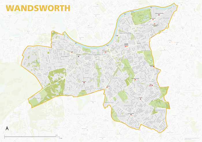
Wandsworth – London borough map
£40.00Map of the London Borough of Wandsworth, detailing the road and public transport network, as well as parks and other open areas. Designed for A1+ printing or editing for other uses.
PDFSVGLayered AI file -
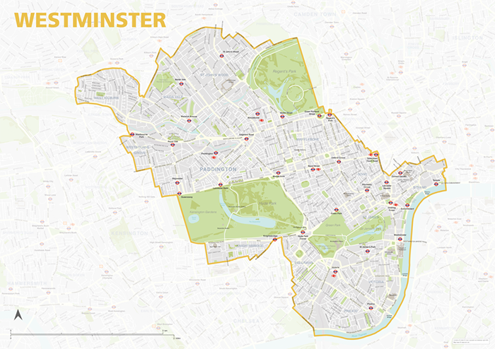
Westminster – London borough map
£40.00Map of the London Borough of Westminster, detailing the road and public transport network, as well as parks and other open areas. Designed for A1+ printing or editing for other uses.
PDFSVGLayered AI file -
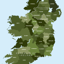
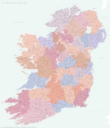
Map of Irish counties
£40.00All the counties in the Republic of Ireland and Northern Ireland
PDFsSVGLayered AI file -
County maps of Britain and Ireland
£45.00Shows all the counties of Britain and Ireland and includes option layers for changing the colour fills and showing county boundaries.
PDFsSVGLayered AI file -
Best detailed map of Ireland
£70.00Approximately 1,400 towns and villages, 17,000+ roads, all the counties and a huge wealth of coastal detail, rivers, urban backdrop and green areas are plotted on our most detailed map of Ireland.
PDFsSVGLayered AI file -
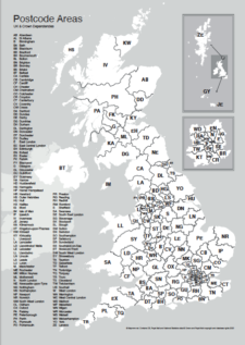
UK postcode areas map for printing “A” format
£15.00Scaled for printing at A4 and above, this map has white postcode areas specially for sales & marketing folk to scribble over with colour pens. Professional designers can edit it too and print it as a wall poster.
PDFs -
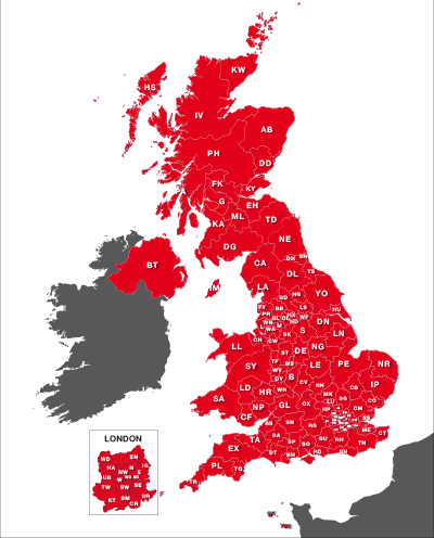
Maps of UK postcode areas
£20.00All the UK two-character postcode areas – 124 areas in total – in five ready-to-use PDF styles, plus access to dynamic postcodes. A bestselling bundle!
PDFsSVGLayered AI file -
Best UK postcodes map with all the postcode districts, post towns and major roads
£75.00Our most detailed downloadable single-image UK postcodes map at a bargain price. Shows all the 4-digit postcode districts in context with post towns, major roads and counties. Five styles are included, or you can use your own colours and fonts.
PDFsSVGLayered AI file -
Best detailed map base of the UK / United Kingdom
£75.00This highly detailed base map of the UK has 1,850 town points, 5,500 roads, admin boundaries and a wealth of natural features. Altogether there are more than 4.29 million vector anchor points making this a superb resource for professional designers.
PDFsSVGLayered AI file -
Map of London postcodes – interlocking shapes
£15.00All the London postcode areas including the central sub-districts are included with accurate, interlocking vector shapes.
PDFsSVGLayered AI file -
UK postcode maps for easy A4 printing – FULL SET with 126 maps
£125.00Full set of the “A” format postcode district maps – 126 maps in total at a huge discount.
PDFs -

Map of AB postcode districts – Aberdeen
£15.00The AB – Aberdeen postcode districts scaled for A4+ printing
PDF -
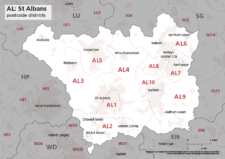
Map of AL postcode districts – St Albans
£15.00The AL – St Albans postcode districts scaled for A4+ printing
PDF -
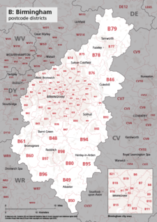
Map of B postcode districts – Birmingham
£15.00The B – Birmingham postcode districts scaled for A4+ printing
PDF -
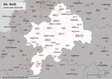
Map of BA postcode districts – Bath
£15.00The BA – Bath postcode districts scaled for A4+ printing
PDF -
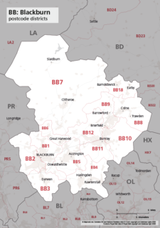
Map of BB postcode districts – Blackburn
£15.00The BB – Blackburn postcode districts scaled for A4+ printing
PDF -
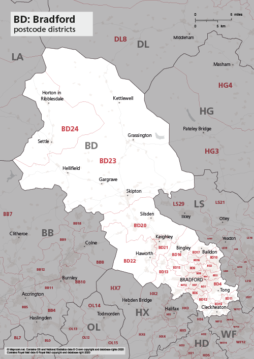
Map of BD postcode districts – Bradford
£15.00The BD – Bradford postcode districts scaled for A4+ printing
PDF -
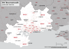
Map of BH postcode districts – Bournemouth
£15.00The BH – Bournemouth postcode districts scaled for A4+ printing
PDF -
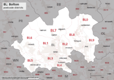
Map of BL postcode districts – Bolton
£15.00The BL – Bolton postcode districts scaled for A4+ printing
PDF -
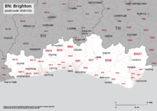
Map of BN postcode districts – Brighton
£15.00The BN – Brighton postcode districts scaled for A4+ printing
PDF -
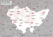
Map of BR postcode districts – Bromley
£15.00The BR – Bromley postcode districts scaled for A4+ printing
PDF -

Map of BS postcode districts – Bristol
£15.00The BS – Bristol postcode districts scaled for A4+ printing
PDF -
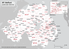
Map of BT postcode districts – Belfast
£15.00The BT – Belfast postcode districts scaled for A4+ printing
PDF -
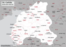
Map of CA postcode districts – Carlisle
£15.00The CA – Carlisle postcode districts scaled for A4+ printing
PDF -

Map of CB postcode districts – Cambridge
£15.00The CB – Cambridge postcode districts scaled for A4+ printing
PDF -
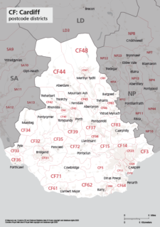
Map of CF postcode districts – Cardiff
£15.00The CF – Cardiff postcode districts scaled for A4+ printing
PDF -

Map of CH postcode districts – Chester
£15.00The CH – Chester postcode districts scaled for A4+ printing
PDF -
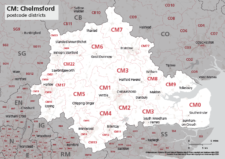
Map of CM postcode districts – Chelmsford
£15.00The CM – Chelmsford postcode districts scaled for A4+ printing
PDF -
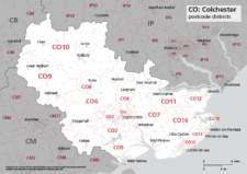
Map of CO postcode districts – Colchester
£15.00The CO – Colchester postcode districts scaled for A4+ printing
PDF -
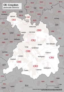
Map of CR postcode districts – Croydon
£15.00The CR – Croydon postcode districts scaled for A4+ printing
PDF -
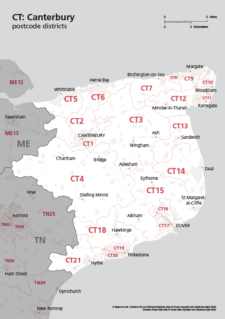
Map of CT postcode districts – Canterbury
£15.00The CT – Canterbury postcode districts scaled for A4+ printing
PDF -
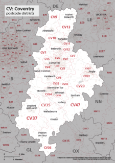
Map of CV postcode districts – Coventry
£15.00The CV – Coventry postcode districts scaled for A4+ printing
PDF -
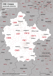
Map of CW postcode districts – Crewe
£15.00The CW – Crewe postcode districts scaled for A4+ printing
PDF -
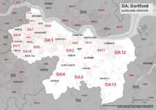
Map of DA postcode districts – Dartford
£15.00The DA – Dartford postcode districts scaled for A4+ printing
PDF -
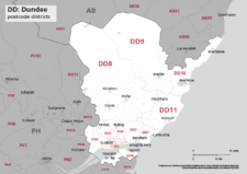
Map of DD postcode districts – Dundee
£15.00The DD – Dundee postcode districts scaled for A4+ printing
PDF -
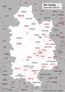
Map of DE postcode districts – Derby
£15.00The DE – Derby postcode districts scaled for A4+ printing
PDF -
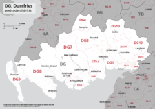
Map of DG postcode districts – Dumfries
£15.00The DG – Dumfries postcode districts scaled for A4+ printing
PDF -
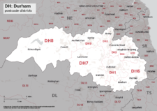
Map of DH postcode districts – Durham
£15.00The DH – Durham postcode districts scaled for A4+ printing
PDF -
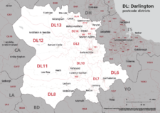
Map of DL postcode districts – Darlington
£15.00The DL – Darlington postcode districts scaled for A4+ printing
PDF -
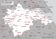
Map of DN postcode districts – Doncaster
£15.00The DN – Doncaster postcode districts scaled for A4+ printing
PDF -
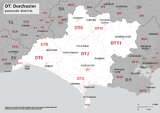
Map of DT postcode districts – Dorchester
£15.00The DT – Dorchester postcode districts scaled for A4+ printing
PDF -
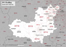
Map of DY postcode districts – Dudley
£15.00The DY – Dudley postcode districts scaled for A4+ printing
PDF -
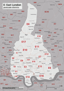
Map of E postcode districts – East London
£15.00The E – East London postcode districts scaled for A4+ printing
PDF -
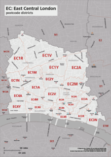
Map of EC postcode districts – East Central London
£15.00The EC – East Central London postcode districts scaled for A4+ printing
PDF -
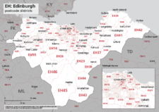
Map of EH postcode districts – Edinburgh
£15.00The EH – Edinburgh postcode districts scaled for A4+ printing
PDF -
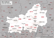
Map of EN postcode districts – Enfield
£15.00The EN – Enfield postcode districts scaled for A4+ printing
PDF -
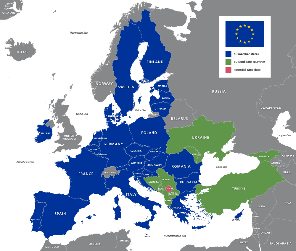
Map of EU countries 2026
£20.00Up-to-date map of the European Union including candidate countries
PDFsSVGLayered AI file -
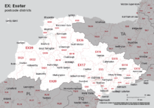
Map of EX postcode districts – Exeter
£15.00The EX – Exeter postcode districts scaled for A4+ printing
PDF -
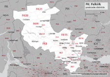
Map of FK postcode districts – Falkirk
£15.00The FK – Falkirk postcode districts scaled for A4+ printing
PDF -
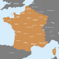
Map of France – French regions
£15.00A beautifully detailed outline of France and her main administrative regions
PDFsSVGLayered AI file -
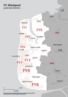
Map of FY postcode districts – Blackpool
£15.00The FY – Blackpool postcode districts scaled for A4+ printing
PDF -
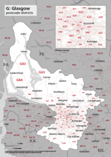
Map of G postcode districts – Glasgow
£15.00The G – Glasgow postcode districts scaled for A4+ printing
PDF -
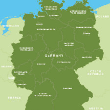
Map of Germany – German states / Bundesländer
£15.00Map of Germany with the boundaries of the 16 federal states / Bundesländer
PDFsSVGLayered AI file -
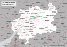
Map of GL postcode districts – Gloucester
£15.00The GL – Gloucester postcode districts scaled for A4+ printing
PDF -
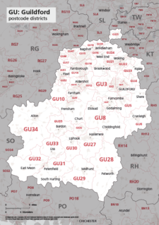
Map of GU postcode districts – Guildford
£15.00The GU – Guildford postcode districts scaled for A4+ printing
PDF -
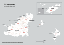
Map of GY postcode districts – Guernsey
£15.00The GY – Guernsey postcode districts scaled for A4+ printing
PDF -
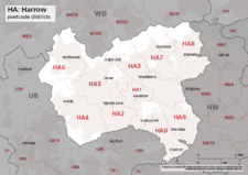
Map of HA postcode districts – Harrow
£15.00The HA – Harrow postcode districts scaled for A4+ printing
PDF -
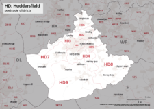
Map of HD postcode districts – Huddersfield
£15.00The HD – Huddersfield postcode districts scaled for A4+ printing
PDF -
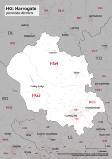
Map of HG postcode districts – Harrogate
£15.00The HG – Harrogate postcode districts scaled for A4+ printing
PDF -
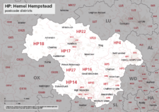
Map of HP postcode districts – Hemel Hempstead
£15.00The HP – Hemel Hempstead postcode districts scaled for A4+ printing
PDF -

Map of HR postcode districts – Hereford
£15.00The HR – Hereford postcode districts scaled for A4+ printing
PDF -
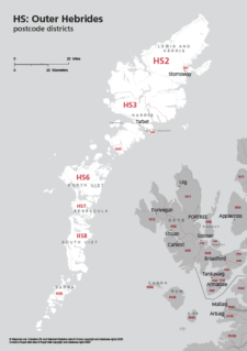
Map of HS postcode districts – Outer Hebrides
£15.00The HS – Outer Hebrides postcode districts scaled for A4+ printing
PDF -
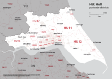
Map of HU postcode districts – Hull
£15.00The AB – Aberdeen postcode districts scaled for A4+ printing
PDF -
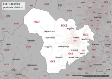
Map of HX postcode districts – Halifax
£15.00The HX – Halifax postcode districts scaled for A4+ printing
PDF -
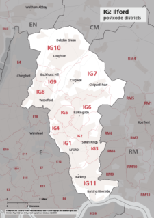
Map of IG postcode districts – Ilford
£15.00The IG – Ilford postcode districts scaled for A4+ printing
PDF -
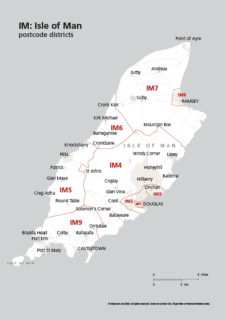
Map of IM postcode districts – Isle of Man
£15.00The IM – Isle of Man postcode districts scaled for A4+ printing
PDF -
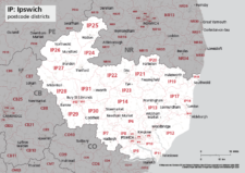
Map of IP postcode districts – Ipswich
£15.00The IP – Ipswich postcode districts scaled for A4+ printing
PDF -
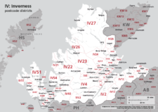
Map of IV postcode districts – Inverness
£15.00The IV – Inverness postcode districts scaled for A4+ printing
PDF -
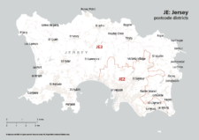
Map of JE postcode districts – Jersey
£15.00The JE – Jersey postcode districts scaled for A4+ printing
PDF -
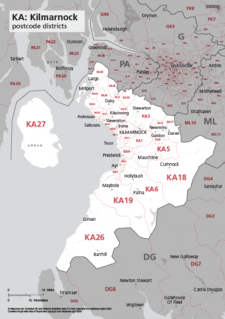
Map of KA postcode districts – Kilmarnock
£15.00The KA – Kilmarnock postcode districts scaled for A4+ printing
PDF -
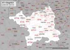
Map of KT postcode districts – Kingston-upon-Thames
£15.00The KT – Kingston upon Thames postcode districts scaled for A4+ printing
PDF -
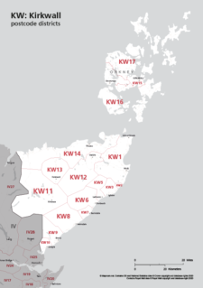
Map of KW postcode areas – Kirkwall
£15.00The KW – Kirkwall postcode districts scaled for A4+ printing
PDF -
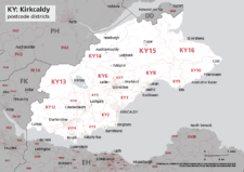
Map of KY postcode districts – Kirkcaldy
£15.00The KY – Kirkcaldy postcode districts scaled for A4+ printing
PDF -
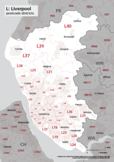
Map of L postcode districts – Liverpool
£15.00The L – Liverpool postcode districts scaled for A4+ printing
PDF -
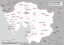
Map of LA postcode districts – Lancaster
£15.00The LA – Lancaster postcode districts scaled for A4+ printing
PDF -
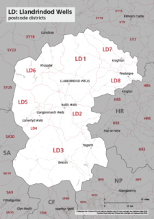
Map of LD postcode districts – Llandrindod Wells
£15.00The LD – Llandrindrod Wells postcode districts scaled for A4+ printing
PDF -
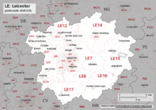
Map of LE postcode districts – Leicester
£15.00The LE – Leicester postcode districts scaled for A4+ printing
PDF -
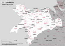
Map of LL postcode districts – Llandudno
£15.00The LL – Llandudno postcode districts scaled for A4+ printing
PDF -
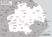
Map of LN postcode districts – Lincoln
£15.00The LN – Lincoln postcode districts scaled for A4+ printing
PDF -
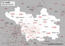
Map of LS postcode districts – Leeds
£15.00The LS – Leeds postcode districts scaled for A4+ printing
PDF -
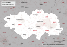
Map of LU postcode districts – Luton
£15.00The LU – Luton postcode districts scaled for A4+ printing
PDF -
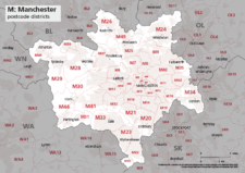
Map of M postcode districts – Manchester
£15.00The M – Manchester postcode districts scaled for A4+ printing
PDF -
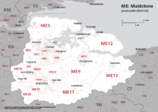
Map of ME postcode districts – Rochester / Medway
£15.00The ME – Maidstone postcode districts scaled for A4+ printing
PDF -
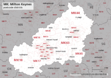
Map of MK postcode districts – Milton Keynes
£15.00The MK – Milton Keynes postcode districts scaled for A4+ printing
PDF -
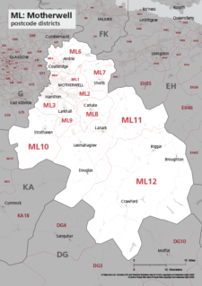
Map of ML postcode districts – Motherwell
£15.00The ML – Motherwell postcode districts scaled for A4+ printing
PDF -
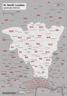
Map of N postcode districts – North London
£15.00The N – North London postcode districts scaled for A4+ printing
PDF -
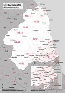
Map of NE postcode districts – Newcastle-upon-Tyne
£15.00The AB – Aberdeen postcode districts scaled for A4+ printing
PDF -
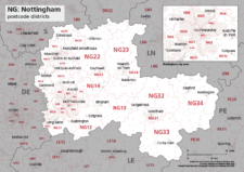
Map of NG postcode districts – Nottingham
£15.00The NG – Nottingham postcode districts scaled for A4+ printing
PDF -

Map of NN postcode districts – Northampton
£15.00The NN – Northampton postcode districts scaled for A4+ printing
PDF -
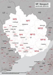
Map of NP postcode districts – Newport
£15.00The NP – Newport postcode districts scaled for A4+ printing
PDF -
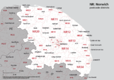
Map of NR postcode districts – Norwich
£15.00The NR – Norwich postcode districts scaled for A4+ printing
PDF -
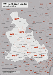
Map of NW postcode districts – North West London
£15.00The NW – North West London postcode districts scaled for A4+ printing
PDF -
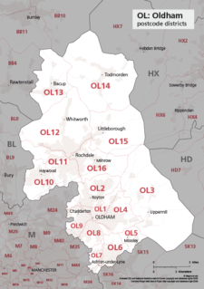
Map of OL postcode districts – Oldham
£15.00The OL – Oldham postcode districts scaled for A4+ printing
PDF -
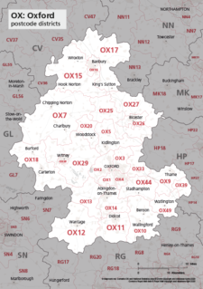
Map of OX postcode districts – Oxford
£15.00The OX – Oxford postcode districts scaled for A4+ printing
PDF -
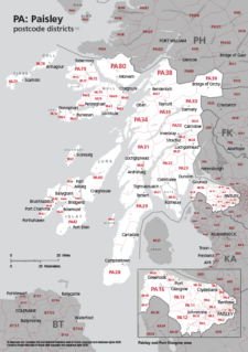
Map of PA postcode districts – Paisley
£15.00The PA – Paisley postcode districts scaled for A4+ printing
PDF -

Map of PE postcode districts – Peterborough
£15.00The PE – Peterborough postcode districts scaled for A4+ printing
PDF -
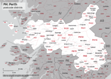
Map of PH postcode districts – Perth
£15.00The PH – Perth postcode districts scaled for A4+ printing
PDF -

Map of PL postcode districts – Plymouth
£15.00The PL – Plymouth postcode districts scaled for A4+ printing
PDF -
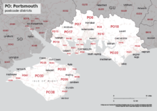
Map of PO postcode districts – Portsmouth
£15.00The PO – Portsmouth postcode districts scaled for A4+ printing
PDF -
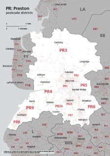
Map of PR postcode districts – Preston
£15.00The PR – Preston postcode districts scaled for A4+ printing
PDF -
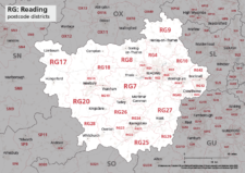
Map of RG postcode districts – Reading
£15.00The RG – Reading postcode districts scaled for A4+ printing
PDF -
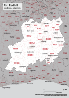
Map of RH postcode districts – Redhill
£15.00The RH – Redhill postcode districts scaled for A4+ printing
PDF -
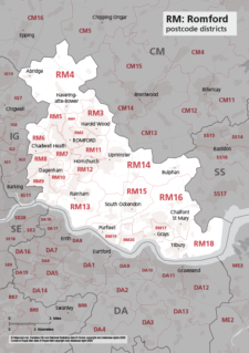
Map of RM postcode districts – Romford
£15.00The RM – Romford postcode districts scaled for A4+ printing
PDF -
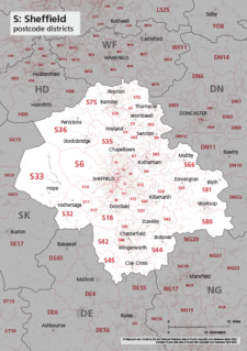
Map of S postcode districts – Sheffield
£15.00The S – Sheffield postcode districts scaled for A4+ printing
PDF -
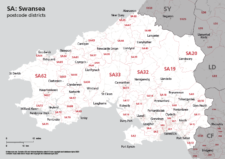
Map of SA postcode districts – Swansea
£15.00The SA – Swansea postcode districts scaled for A4+ printing
PDF -
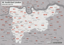
Map of SE postcode districts – South East London
£15.00The SE – South East London postcode districts scaled for A4+ printing
PDF -
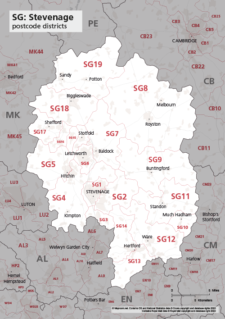
Map of SG postcode districts – Stevenage
£15.00The SG – Stevenage postcode districts scaled for A4+ printing
PDF -

Map of SK postcode districts – Stockport
£15.00The SK – Stockport postcode districts scaled for A4+ printing
PDF -
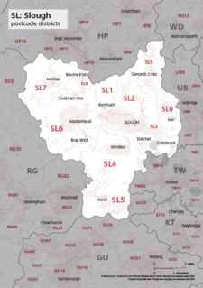
Map of SL postcode districts – Slough
£15.00The SL – Slough postcode districts scaled for A4+ printing
PDF -
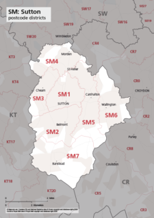
Map of SM postcode districts – Sutton
£15.00The SM – Sutton postcode districts scaled for A4+ printing
PDF -
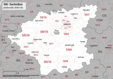
Map of SN postcode districts – Swindon
£15.00The SN – Swindon postcode districts scaled for A4+ printing
PDF -
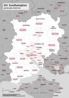
Map of SO postcode districts – Southampton
£15.00The SO – Southampton postcode districts scaled for A4+ printing
PDF -
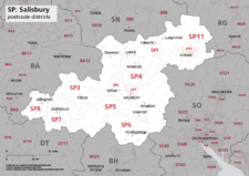
Map of SP postcode districts – Salisbury
£15.00The SP – Salisbury postcode districts scaled for A4+ printing
PDF