Maproom

Editable & interactive maps

MENUMENU
  • about
  • news
  • contact
  • 0 items
LOGIN
    • Home
  • Britain & Ireland maps
    • Britain and Ireland
    • UK - United Kingdom
    • Ireland
    • England
    • Scotland
    • Wales
    • Northern Ireland
    • Isle of Man
    • Channel Islands
  • City maps
    • Birmingham
    • Brighton
    • Bristol
    • Cardiff
    • Edinburgh
    • Glasgow
    • Liverpool
    • London
    • Manchester
    • Oxford
  • Postcode maps
    • Overview
    • Online postcode mapping tools
    • Downloadable postcode maps
  • Boundary & transport maps
    • Boundary and ONS maps
    • Local authority maps
    • County maps
    • Transport maps
  • World maps
    • World maps
    • Europe maps
    • Map of EU countries 2023
    • Maps of France
    • Maps of Germany
    • Maps of New York and environs
  • DYNAMIC
    • Showcase
    • Dynamic Mapping Suite information and demos
    • GET A PASS
  • BESPOKE
    • Bespoke mapping services
    • Bespoke static maps
    • Bespoke dynamic maps
    • Search

Postcode Mapping

Online postcode maps

  • Postcode mapping tools
  • Dynamic postcodes reference
  • GET A PASS

Downloadable postcode maps

  • UK postcodes
  • London postcodes
  • Postcodes scaled for easy A4 printing
    • FULL SET with 126 maps
    • Central London – W1, WC, EC
    • AB – Aberdeen
    • AL – St Albans
    • B – Birmingham
    • BA – Bath
    • BB – Blackburn
    • BD – Bradford
    • BH – Bournemouth
    • BL – Bolton
    • BN – Brighton
    • BR – Bromley
    • BS – Bristol
    • BT – Belfast
    • CA – Carlisle
    • CB – Cambridge
    • CF – Cardiff
    • CH – Chester
    • CM – Chelmsford
    • CO – Colchester
    • CR – Croydon
    • CT – Canterbury
    • CV – Coventry
    • CW – Crewe
    • DA – Dartford
    • DD – Dundee
    • DE – Derby
    • DG – Dumfries
    • DH – Durham
    • DL – Darlington
    • DN – Doncaster
    • DT – Dorchester
    • DY – Dudley
    • E – East London
    • EC – East Central London
    • EH – Edinburgh
    • EN – Enfield
    • EX – Exeter
    • FK – Falkirk
    • FY – Blackpool
    • G – Glasgow
    • GL – Gloucester
    • GU – Guildford
    • GY – Guernsey
    • HA – Harrow
    • HD – Huddersfield
    • HG – Harrogate
    • HP – Hemel Hempstead
    • HR – Hereford
    • HS – Outer Hebrides
    • HU – Hull
    • HX – Halifax
    • IG – Ilford
    • IM – Isle of Man
    • IP – Ipswich
    • IV – Inverness
    • JE – Jersey
    • KA – Kilmarnock
    • KT – Kingston-upon-Thames
    • KW – Kirkwall
    • KY – Kirkcaldy
    • L – Liverpool
    • LA – Lancaster
    • LD – Llandrindod Wells
    • LE – Leicester
    • LL – Llandudno
    • LN – Lincoln
    • LS – Leeds
    • LU – Luton
    • M – Manchester
    • ME – Rochester / Medway
    • MK – Milton Keynes
    • ML – Motherwell
    • N – North London
    • NE – Newcastle-upon-Tyne
    • NG – Nottingham
    • NN – Northampton
    • NP – Newport
    • NR – Norwich
    • NW – North West London
    • OL – Oldham
    • OX – Oxford
    • PA – Paisley
    • PE – Peterborough
    • PH – Perth
    • PL – Plymouth
    • PO – Portsmouth
    • PR – Preston
    • RG – Reading
    • RH – Redhill
    • RM – Romford
    • S – Sheffield
    • SA – Swansea
    • SE – South East London
    • SG – Stevenage
    • SK – Stockport
    • SL – Slough
    • SM – Sutton
    • SN – Swindon
    • SO – Southampton
    • SP – Salisbury
    • SR – Sunderland
    • SS – Southend-on-Sea
    • ST – Stoke-on-Trent
    • SW – South West London
    • SY – Shrewsbury
    • TA – Taunton
    • TD – Galashiels / Tweeddale
    • TF – Telford
    • TN – Tonbridge
    • TQ – Torquay
    • TR – Truro
    • TS – Cleveland / Teesside
    • TW – Twickenham
    • UB – Uxbridge / Southall
    • W – West London
    • WA – Warrington
    • WC – West Central London
    • WD – Watford
    • WF – Wakefield
    • WN – Wigan
    • WR – Worcester
    • WS – Walsall
    • WV – Wolverhampton
    • YO – York
    • ZE – Lerwick

Postcodes in clean air and low emission zones

Maproom’s Dynamic Mapping Suite includes an all-in-one interactive online map that juxtaposes postcode districts, sectors and units with the UK’s low emission urban traffic charging zones. You only need to purchase access once to cover all these traffic zones. Use the interactive indexes to quick-zoom to your postcodes of interest and see at a glance which sectors and districts are affected. Plot your service areas in and around these zones online. Learn more

Showing all 14 results

  • Aberdeen Low Emission Zone LEZ map + AB postcode boundaries interactive map preview

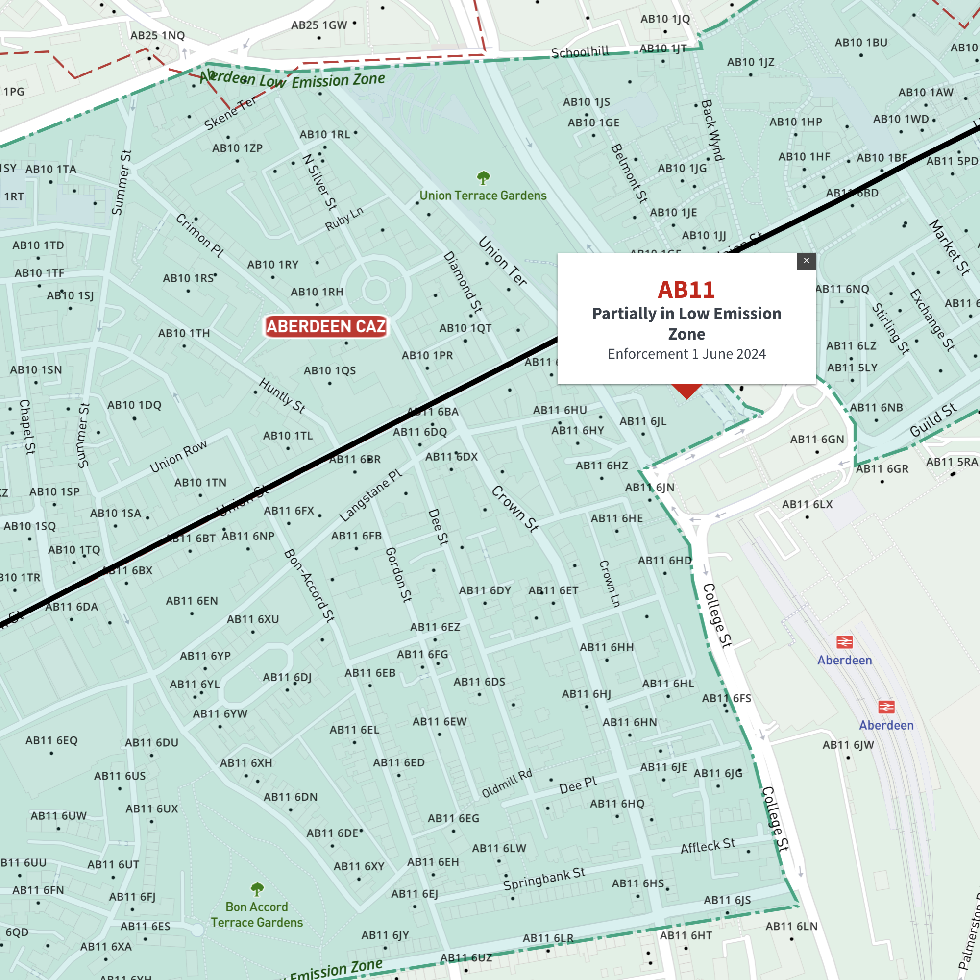
    Interactive map of Aberdeen Low Emission Zone and all AB postcodes

    £35.00

    Online deep-zoom map of Aberdeen Low Emission Zone (LEZ) with AB postcode districts, sectors and units available in the Dynamic Mapping Suite

    Dynamic Mapping Suite Premium Pass
  • Bath Clean Air Zone map with BA postcode boundaries - interactive map preview

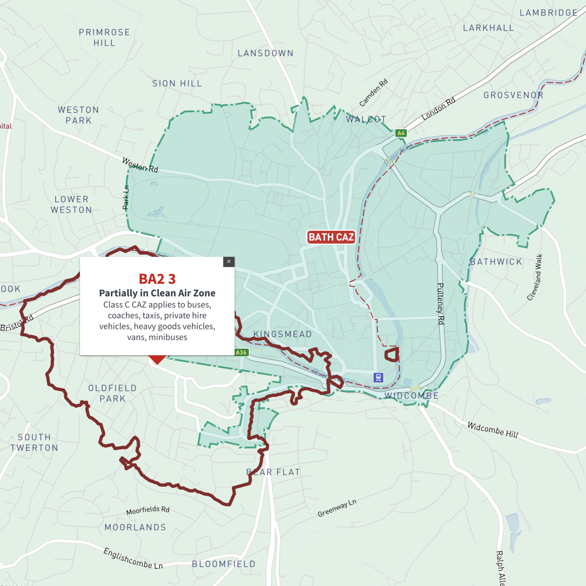
    Interactive map of Bath Clean Air Zone and all BA postcodes

    £35.00

    Online deep-zoom map of Bath Clean Air Zone (CAZ) with BA postcode districts, sectors and units available in the Dynamic Mapping Suite

    Dynamic Mapping Suite Premium Pass
  • Birmingham Clean Air Zone map and B postcode boundaries interactive map preview

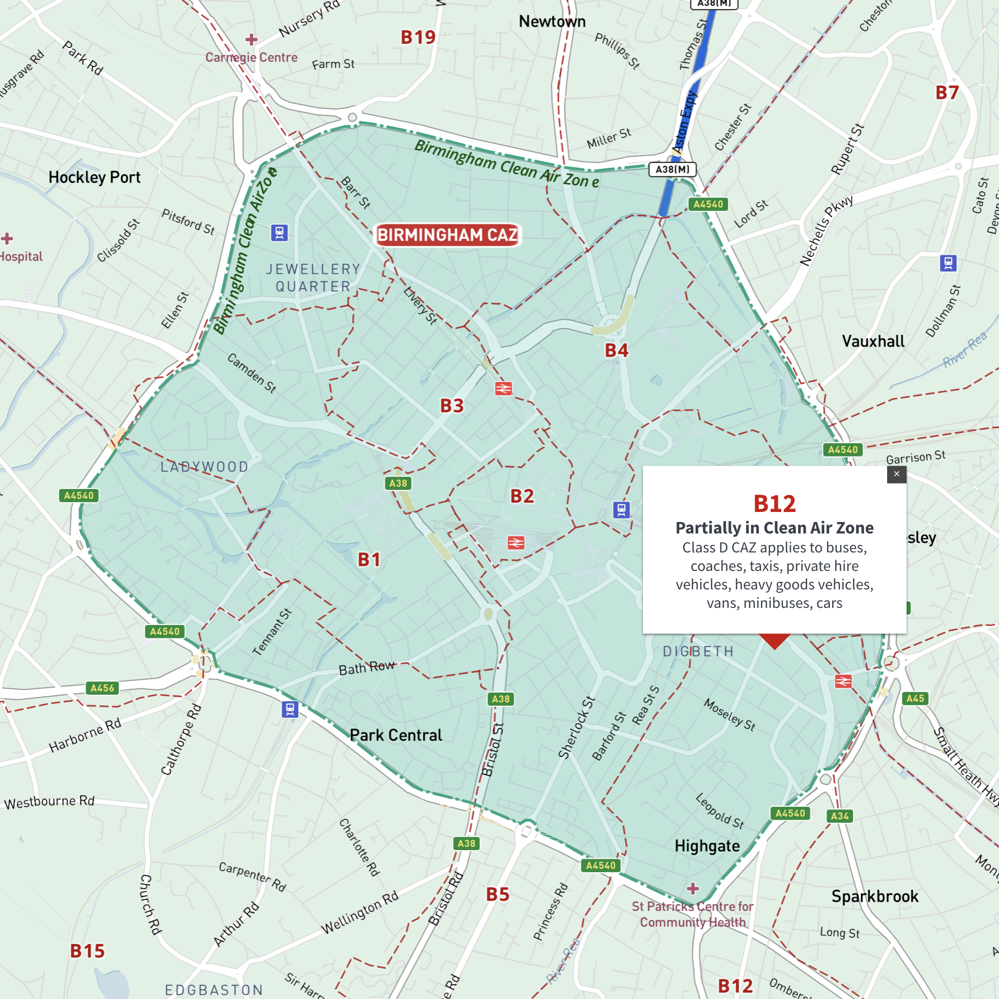
    Interactive map of Birmingham Clean Air Zone with postcodes

    £35.00

    This interactive street map of Birmingham has overlays and popups showing the Clean Air Zone juxtaposed with postcodes. It is aimed primarily at businesses needing reference to plan deliveries, driving routes and sales territories in and around Birmingham’s Clean Air Zone.

    Dynamic Mapping Suite Premium Pass
  • Bradford Clean Air Zone map with BD postcode boundaries - interactive map preview

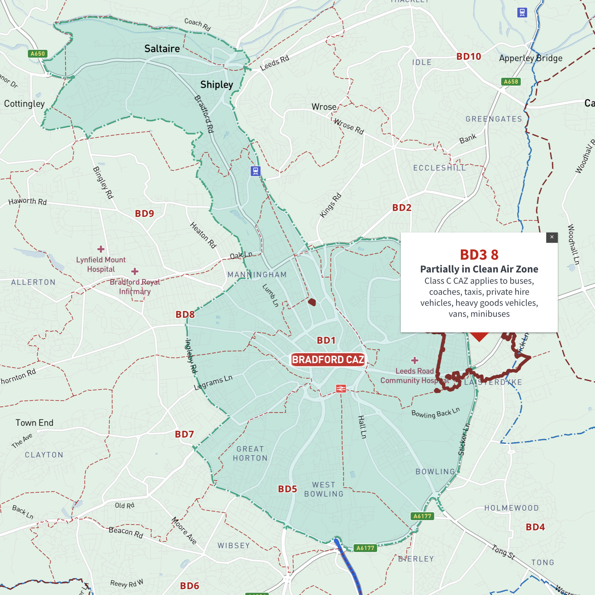
    Interactive map of Bradford Clean Air Zone and all BD postcodes

    £35.00

    Online deep-zoom map of Bradford Clean Air Zone (CAZ) with BD postcode districts, sectors and units available in the Dynamic Mapping Suite

    Dynamic Mapping Suite Premium Pass
  • Bristol Clean Air Zone map and BS postcode boundaries interactive map preview

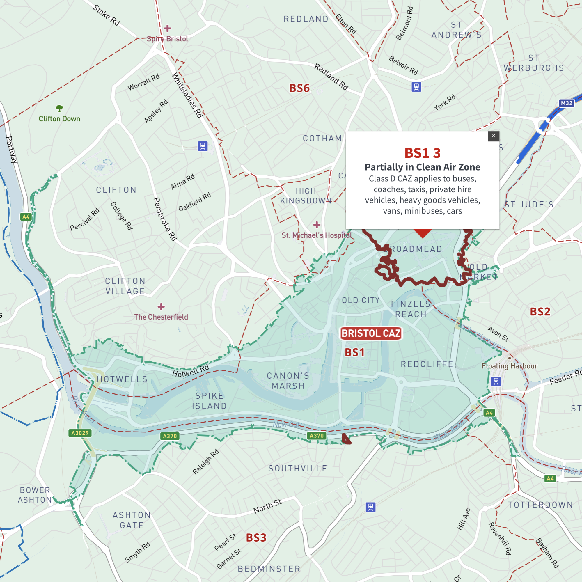
    Interactive map of Bristol Clean Air Zone and all BS postcodes

    £35.00

    Online deep-zoom map of Bristol Clean Air Zone (CAZ) with BS postcode districts, sectors and units available in the Dynamic Mapping Suite

    Dynamic Mapping Suite Premium Pass
  • Dundee Clean Air Zone map with DD postcode boundaries - interactive map preview

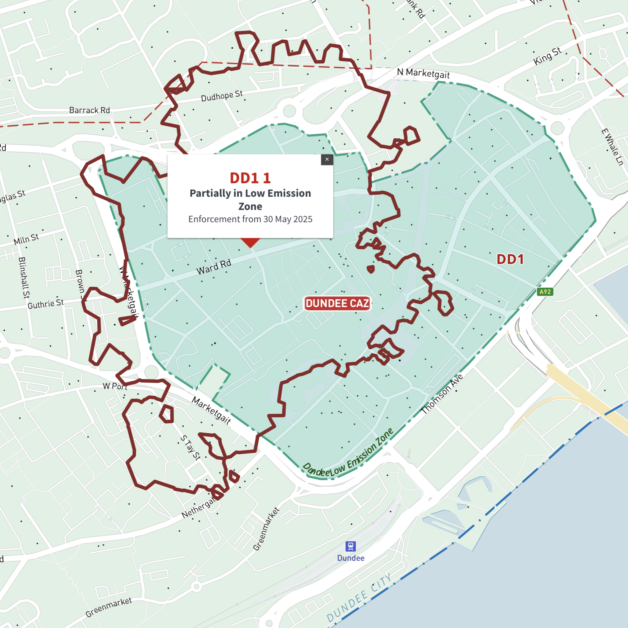
    Interactive map of Dundee Low Emission Zone and all DD postcodes

    £35.00

    Online deep-zoom map of Dundee Low Emission Zone (LEZ) with DD postcode districts, sectors and units available in the Dynamic Mapping Suite

    Dynamic Mapping Suite Premium Pass
  • Edinburgh Low Emission Zone map with interactive EH postcode boundaries preview

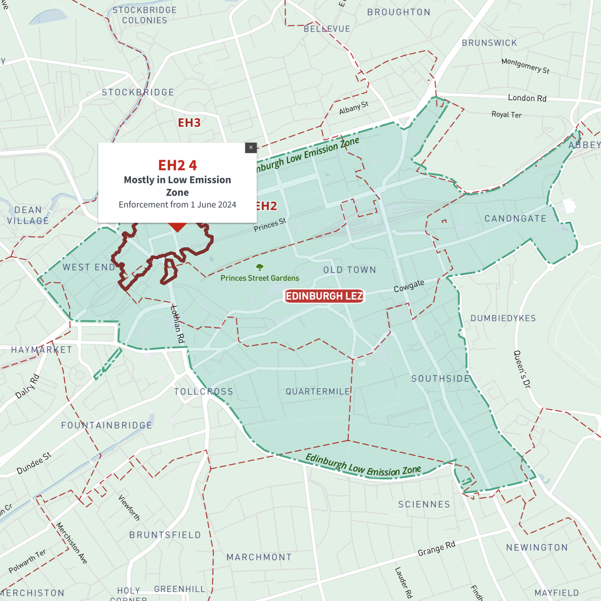
    Interactive map of Edinburgh Low Emission Zone and all EH postcodes

    £35.00

    Online deep-zoom map of Edinburgh Low Emission Zone (LEZ) with EH postcode districts, sectors and units available in the Dynamic Mapping Suite

    Dynamic Mapping Suite Premium Pass
  • Glasgow Low Emission Zone map LEZ with G postcodes - interactive map preview

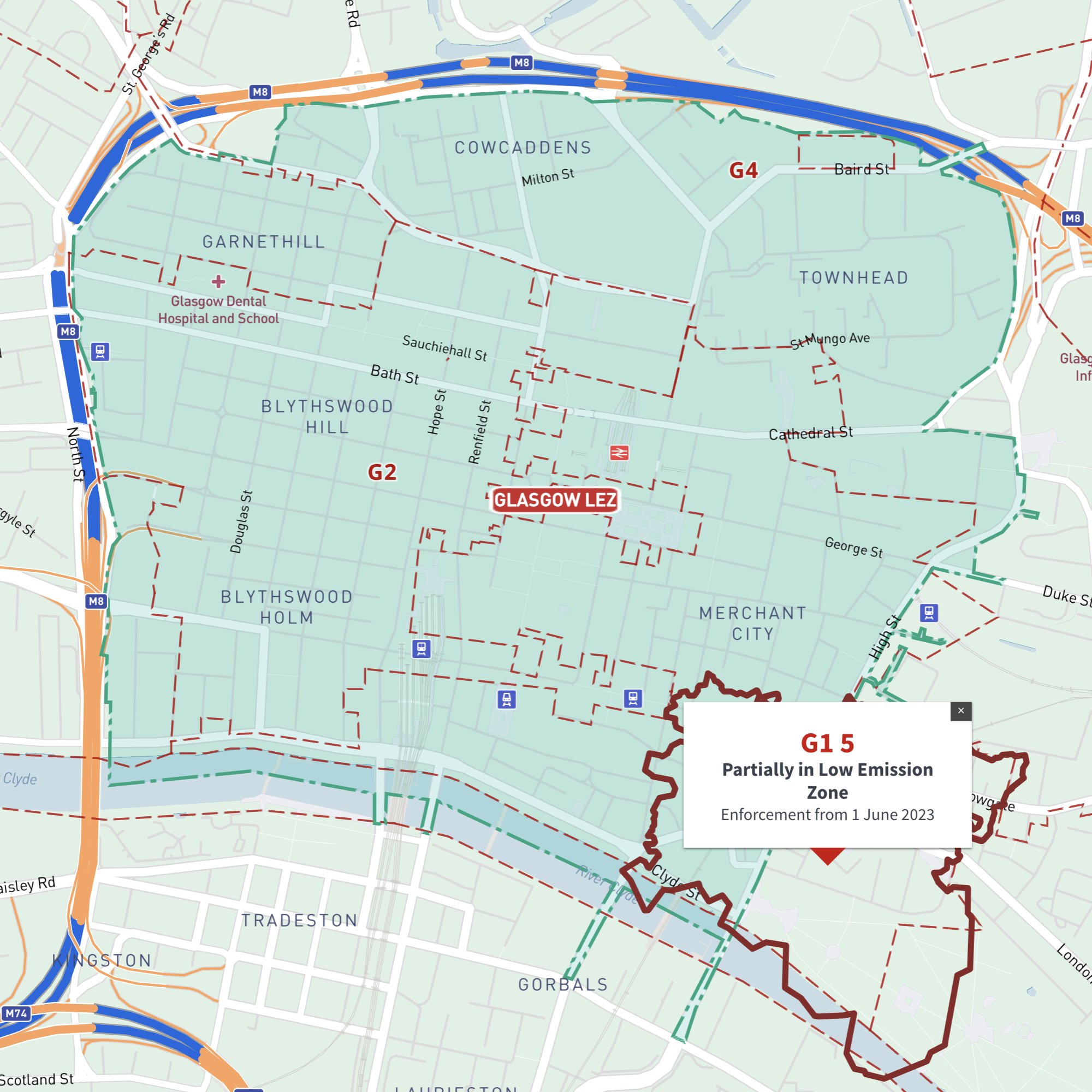
    Interactive map of Glasgow Low Emission Zone and all G postcodes

    £35.00

    Online deep-zoom map of Glasgow Low Emission Zone (LEZ) with G postcode districts, sectors and units available in the Dynamic Mapping Suite

    Dynamic Mapping Suite Premium Pass
  • Greater Manchester Clean Air Zone map with M, OL, BL, WN, WA, SK postcode boundaries - interactive map preview

    Interactive map of Greater Manchester Clean Air Zone and all M, BL, OL, SK, WA and WN postcodes

    £35.00

    Online deep-zoom map of Greater Manchester Clean Air Zone (CAZ) with M, BL, OL, SK, WA and WN postcode districts, sectors and units available in the Dynamic Mapping Suite

    Dynamic Mapping Suite Premium Pass
  • Greater London ULEZ map - LEZ Low Emission - DVS - Congestion Charge - postcode boundaries - interactive map preview

    Interactive map of London Low and Ultra-low Emission Zones (LEZ / ULEZ), Congestion Charge Zone (CCZ), with all postcodes

    £35.00

    London’s Low Emission Zone and Driver Vision Standard (LEZ / DVS), Ultra-low Emission Zone (ULEZ),  and Congestion Charge Zone (CCZ) juxtaposed with postcodes and local authority / London borough boundaries – this interactive online map is aimed primarily at businesses needing help to plan deliveries, driving routes and sales territories through and around London.

    Dynamic Mapping Suite Premium Pass
  • Oxford proposed Zero Emission Zone ZEZ map and OX postcode boundaries interactive map preview

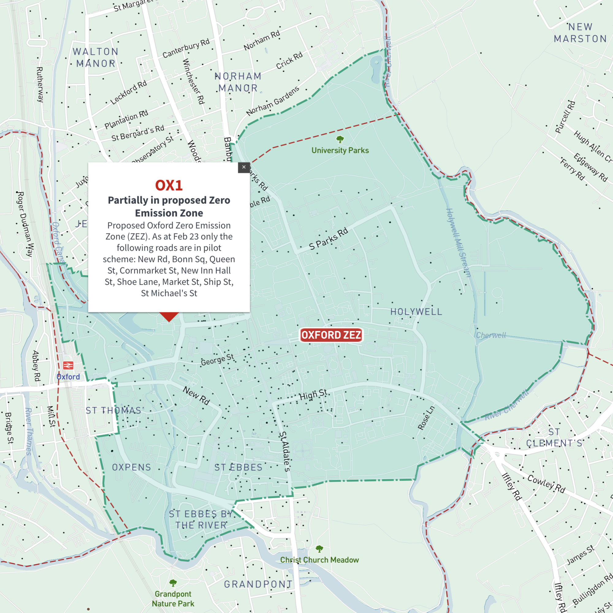
    Interactive map of Oxford Zero Emission Zone and all OX postcodes

    £35.00

    Online deep-zoom map of Oxford Zero Emission Zone (ZEZ) with OX postcode districts, sectors and units available in the Dynamic Mapping Suite

    Dynamic Mapping Suite Premium Pass
  • Portsmouth Clean Air Zone map with PO postcode boundaries - interactive map preview

    Interactive map of Portsmouth Clean Air Zone and all PO postcodes

    £35.00

    Online deep-zoom map of Portsmouth Clean Air Zone (CAZ) with PO postcode districts, sectors and units available in the Dynamic Mapping Suite

    Dynamic Mapping Suite Premium Pass
  • Sheffield Clean Air Zone map with S postcode boundaries - interactive map preview

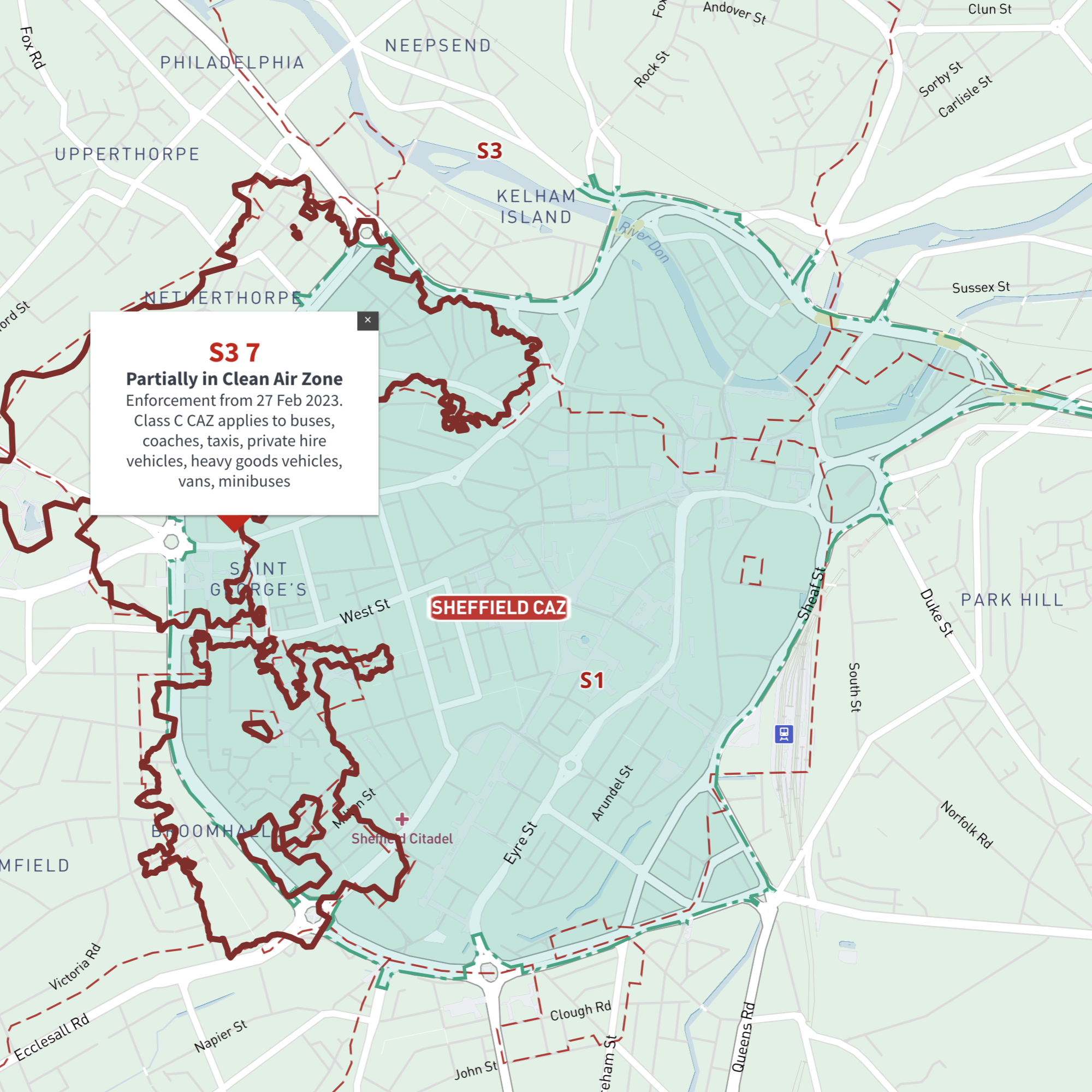
    Interactive map of Sheffield Clean Air Zone and all S postcodes

    £35.00

    Online deep-zoom map with S postcode districts, sectors and units available in the Dynamic Mapping Suite

    Dynamic Mapping Suite Premium Pass
  • Newcastle / Tyneside Clean Air Zone map with NE postcode boundaries - interactive map preview

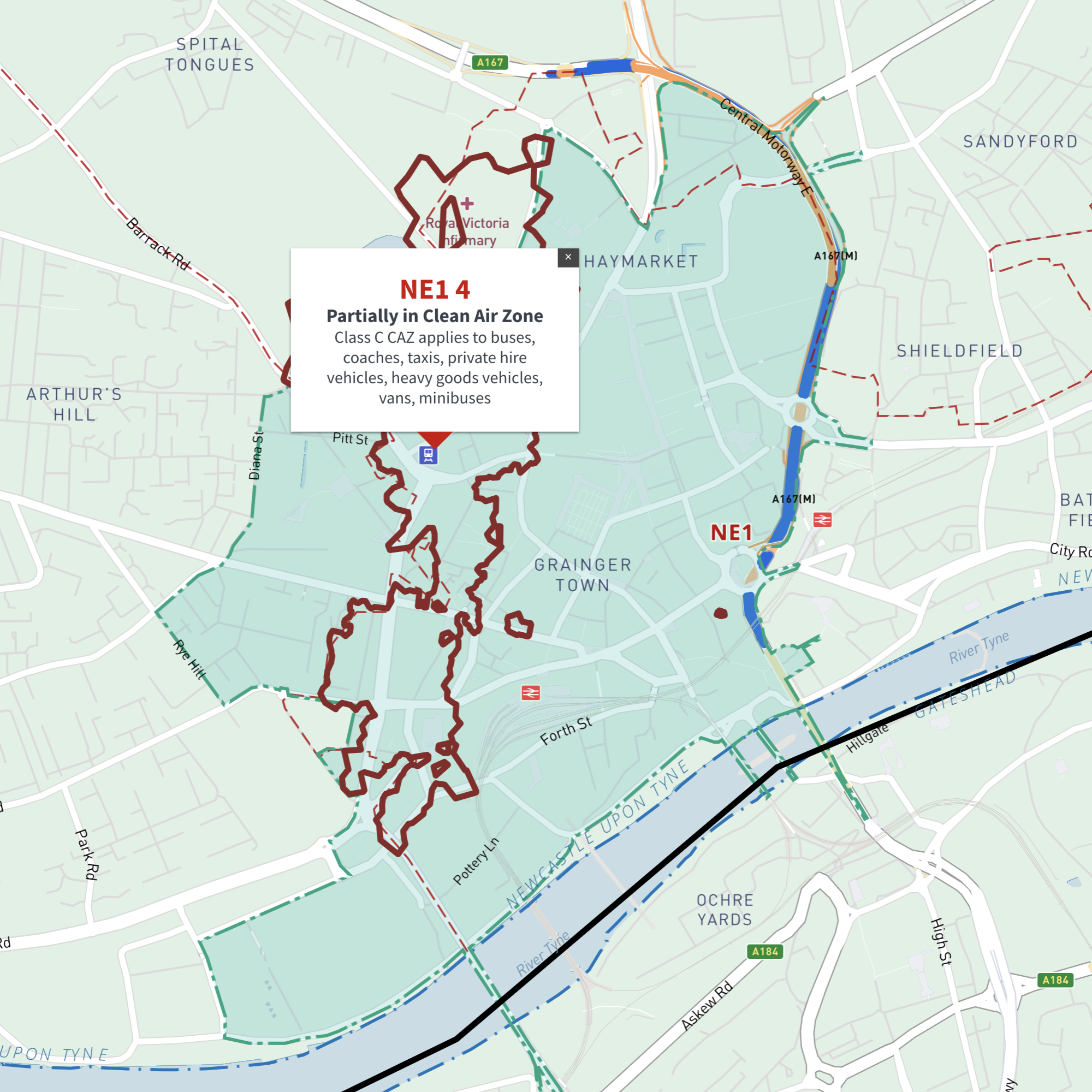
    Interactive map of Tyneside (Newcastle and Gateshead) Clean Air Zone and all NE postcodes

    £35.00

    Online deep-zoom map of Newcastle and Gateshead / Tyneside Clean Air Zone (CAZ) with NE postcode districts, sectors and units available in the Dynamic Mapping Suite

    Dynamic Mapping Suite Premium Pass
  • Standard royalty free terms for downloadable maps
  • Licensing terms for downloadable postcode maps
  • Licensing terms for dynamic online maps
  • How to edit the downloadable maps
  • Pricing & refund policies
  • Privacy & cookies
  • Maproom on Twitter

All content © Maproom at Thameside Media · Award winning media projects