Best UK postcodes map with all the postcode districts, post towns and major roads
Downloadable royalty free vector artwork High-resolution PDFsSVGLayered Adobe Illustrator file Bundled with 7-Day Pass for Dynamic Mapping Suite iPrice £75.00
Zoom preview showing full area of coverage (low-resolution)

Pan to zoom / click or tap to switch
Examples of styling in the zoom previews are included as ready to use high-resolution PDF files in the download package. You can edit all colours, fonts and other elements using Adobe Illustrator or other SVG editing software.
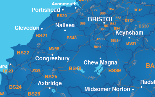
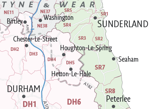
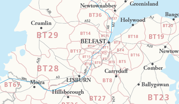
Our most detailed downloadable single-image UK postcodes map shows all the 4-part alphanumeric postcode districts in context with post towns, major roads and counties. That’s nearly 3,000 complex interlocking postcode districts across the whole UK. Five PDF styles are included, which you can use royalty-free either as they are or as a starting point for editing in Adobe Illustrator or other vector graphics software.
This unique UK postcodes map with post towns is a tour-de-force of information created with Royal Mail’s Code-Point Open data carefully married up with Ordnance Survey projections and Maproom’s other postcode base maps – a job that took us weeks of work. Offered with royalty-free terms for any commercial job, Maproom’s best postcodes map base is an absolute bargain given the amount of time it saves for graphic designers.
Bundled with access to dynamic postcodes
In addition to the downloadable map versions, we offer a 7-day Limited Free Pass for our dynamic online postcode maps system with this map bundle. This includes street-level postcode maps and online Quick Select tools for colouring and captioning postcode maps.

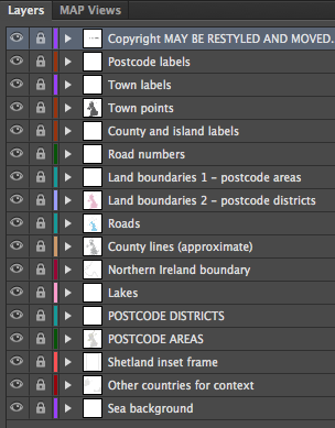
Vector features of the postcode districts map
With easily selectable areas and all the labels in live, editable fonts, you can quickly change colours and scaling to suit your needs, such as colouring up parts of the UK to show salesforce coverage or delivery charges by postcode. The vector base is fully scalable so you can zoom in and out of different parts of the UK without loss of resolution. (The amount of zoom on our JPEG previews here is limited by the maximum size of JPEG that can be uploaded to a web page, but the PDFs included in the download package allow for a deeper zoom and are sharp at all zoom levels.)
By popular demand, we have included approximate county boundaries on this postcodes map. Royal Mail does not follow county boundaries with its postcode divisions, but our customers have told us that it helps to see the counties when using the postcodes map for planning purposes. As far as we know, counties are a unique feature on a postcodes map of this type.
Scaling for this detailed UK postcodes map
The editable AI, SVG and PDF versions of this map are recommended for professional cartographers and graphic designers working in Adobe Illustrator who understand how to scale and output vector artwork. It is a complex piece of vector artwork with more than 1.7 million anchor points. In its opening state, the Illustrator version of this map is nominally 185cm width x 269cm height within the artboard area (see the zoom examples for coverage), with the Channel Islands and Shetland extending beyond the artboard. The smallest postcode districts on this map are legible only when the map is zoomed in beyond 100%. Therefore, you will need to output it as a PDF, or tile the map (break it up into a series of smaller images, such as in an atlas) or zoom into metropolitan areas to make sensible use of it according to your needs. If you want a single poster sized print, you will need to print above A0 size if you want every postcode to be legible across the entire UK. Also check our Greater London postcodes map if you are primarily interested in London, or if you are thinking of producing a secondary zoomed map for the dense London postcodes. It uses the same vector base as this map, but includes more specific detail for London, including the London borough boundaries and numbered A roads.
Specifications
Price £75.00
Product code: MR141
Licensing terms
This editable map base is suitable for commercial and professional uses
See standard royalty free terms for downloadable maps
How to edit
Adobe Illustrator, CorelDRAW, PDF editors etc
See how to edit the downloadable maps
Recommended scaling
Billboard size, tiles or zoomed areas
For more guidance see scaling recommendations
Access to Dynamic Mapping Suite
A 7-Day Full Pass for the Dynamic Mapping Suite is bundled with this map. The Dynamic Mapping Suite is a separate system that includes a set of online mapping tools geared to visualising data for UK administrative areas.
Vector map layers in Illustrator
You may also like…
-

UK Local Authorities + Postcodes Map from April 2023
£60.00UK Local Authorities juxtaposed with postcodes districts, plus a Limited Free Pass for the Dynamic Mapping Suite giving access to online Local Authority maps and mapping tools.
PDFSVGLayered AI file -

Best maps of central London postcode districts – W1, WC, EC – including street names
£25.00See the road names and other street level details of London’s densely packed W1, WC and EC postcode districts overlaid with clear labels, district boundaries and underlying polygons for colour editing.
PDFSVGLayered AI file -

Supersize map of Greater London postcode districts with full road network
£75.00Editable postcodes artwork scaled at 4.3 x 3.8 metres in its opening state. The full road network of Greater London is the backdrop, with major road names legible at large-scale printing.
PDFsLayered AI file